Wraxall is a village in North Somerset, England, about 6 miles (10 km) west of Bristol. Until 1811 the parish of the same name also included Nailsea and Flax Bourton. The village is now within the parish of Wraxall and Failand.
Mendip is a local government district in the English county of Somerset. The Mendip district covers a largely rural area of 285 square miles (738 km2) ranging from the Mendip Hills through on to the Somerset Levels. It has a population of approximately 11,000. The administrative centre of the district is Shepton Mallet.
North Somerset is a unitary authority in the ceremonial county of Somerset, England. In the United Kingdom, the term listed building refers to a building or other structure officially designated as being of special architectural, historical or cultural significance; Grade I structures are those considered to be "buildings of exceptional interest". Listing was begun by a provision in the Town and Country Planning Act 1947. Once listed, severe restrictions are imposed on the modifications allowed to a building's structure or its fittings. In England, the authority for listing under the Planning Act 1990 rests with Historic England, a non-departmental public body sponsored by the Department for Digital, Culture, Media and Sport; local authorities have a responsibility to regulate and enforce the planning regulations.
Sedgemoor is a local government district in the English county of Somerset. In the United Kingdom, the term listed building refers to a building or other structure officially designated as being of special architectural, historical or cultural significance; Grade I structures are those considered to be "buildings of exceptional interest". Listing was begun by a provision in the Town and Country Planning Act 1947. Once listed, severe restrictions are imposed on the modifications allowed to a building's structure or its fittings. In England, the authority for listing under the Planning Act 1990 rests with Historic England, a non-departmental public body sponsored by the Department for Digital, Culture, Media and Sport; local authorities have a responsibility to regulate and enforce the planning regulations.
South Somerset is a local government district in the English county of Somerset. The South Somerset district occupies an area of 370 square miles (958 km2), stretching from its borders with Devon and Dorset to the edge of the Somerset Levels. The district has a population of about 158,000, and has Yeovil as its administrative centre.

West Somerset is a local government district in the county of Somerset which is in South West England. In the United Kingdom, the term listed building refers to a building or other structure officially designated as being of special architectural, historical or cultural significance; Grade II* structures are those considered to be "particularly significant buildings of more than local interest". Listing was begun by a provision in the Town and Country Planning Act 1947. Once listed, severe restrictions are imposed on the modifications allowed to a building's structure or its fittings. In England, the authority for listing under the Planning Act 1990 rests with Historic England, a non-departmental public body sponsored by the Department for Digital, Culture, Media and Sport; local authorities have a responsibility to regulate and enforce the planning regulations.

Bath and North East Somerset is a unitary authority created on 1 April 1996, following the abolition of the County of Avon, which had existed since 1974. Part of the ceremonial county of Somerset, Bath and North East Somerset occupies an area of 220 square miles (570 km2), two-thirds of which is green belt. It stretches from the outskirts of Bristol, south into the Mendip Hills and east to the southern Cotswold Hills and Wiltshire border. The city of Bath is the principal settlement in the district, but BANES also covers Keynsham, Midsomer Norton, Radstock and the Chew Valley. The area has a population of 170,000, about half of whom live in Bath, making it 12 times more densely populated than the rest of the area.

Mendip is a local government district in the English county of Somerset. The Mendip district covers a largely rural area of 285 square miles (738 km2) ranging from the Mendip Hills through on to the Somerset Levels. It had a population of approximately 110,000 in 2014. The administrative centre of the district is Shepton Mallet.
Sedgemoor is a local government district in the English county of Somerset. In the United Kingdom, the term listed building refers to a building or other structure officially designated as being of special architectural, historical or cultural significance; Grade II* structures are those considered to be "particularly significant buildings of more than local interest". Listing was begun by a provision in the Town and Country Planning Act 1947. Once listed, severe restrictions are imposed on the modifications allowed to a building's structure or its fittings. In England, the authority for listing under the Planning Act 1990 rests with Historic England, a non-departmental public body sponsored by the Department for Digital, Culture, Media and Sport; local authorities have a responsibility to regulate and enforce the planning regulations.
South Somerset is a local government district in the English county of Somerset. The South Somerset district occupies an area of 370 square miles (958 km2), stretching from its borders with Devon and Dorset to the edge of the Somerset Levels. The district has a population of about 158,000, and has Yeovil as its administrative centre.

Taunton Deane is a local government district with borough status in the English county of Somerset. In the United Kingdom, the term listed building refers to a building or other structure officially designated as being of special architectural, historical or cultural significance; Grade II* structures are those considered to be "particularly significant buildings of more than local interest". Listing was begun by a provision in the Town and Country Planning Act 1947. Once listed, severe restrictions are imposed on the modifications allowed to a building's structure or its fittings. In England, the authority for listing under the Planning Act 1990 rests with Historic England, a non-departmental public body sponsored by the Department for Digital, Culture, Media and Sport; local authorities have a responsibility to regulate and enforce the planning regulations.

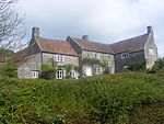
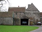
Barrow Court is a manor house in Barrow Gurney, Somerset, England. The site was originally Barrow Gurney Nunnery and was rebuilt in the 16th and 19th centuries. It has been designated as a Grade II* listed building.

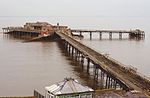
Sand Point in Somerset, England, is the peninsula stretching out from Middle Hope, an 84.1-hectare (208-acre) biological and geological Site of Special Scientific Interest. It lies to the north of the village of Kewstoke, and the stretch of coastline called Sand Bay north of the town of Weston-super-Mare. On a clear day it commands views over Flat Holm, of the Bristol Channel, South Wales, Clevedon, the Second Severn Crossing and the Severn Bridge. A line drawn between Sand Point and Lavernock Point in South Wales marks the lower limit of the Severn Estuary and the start of the Bristol Channel.
Taunton Deane was a local government district with borough status in Somerset, England. It merged with West Somerset to form Somerset West and Taunton on 1 April 2019. Its council was based in Taunton. The district was formed on 1 April 1974, under the Local Government Act 1972, by a merger of the Municipal Borough of Taunton, Wellington Urban District, Taunton Rural District, and Wellington Rural District. Taunton Deane was granted borough status in 1975, enabling the mayoralty of Taunton to be continued, when other districts did not have mayors. The district was given the name of an alternate form of the Taunton Deane Hundred.

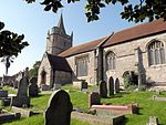
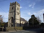
The Anglican Church of All Saints in Long Ashton was built in the 14th century although much of the fabric was rebuilt in the 1870s. It is a Grade II* listed building.
West Somerset was a local government district in the English county of Somerset. It merged with Taunton Deane to form Somerset West and Taunton on 1 April 2019.