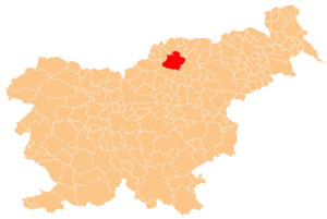
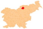
Mislinja is a settlement in northern Slovenia. It is the seat of the Municipality of Mislinja. It lies in the valley of the Mislinja River. The area traditionally belonged to Styria. In 1995 it became part of the newly formed Carinthia Statistical Region.

Košnica pri Celju is a settlement in the City Municipality of Celje in eastern Slovenia. It lies on the right bank of the Savinja River on the southwestern outskirts of Celje. The area was traditionally part of the Styria region. It is now included with the rest of the municipality in the Savinja Statistical Region.
Gmajna is a dispersed settlement in the City Municipality of Slovenj Gradec in northern Slovenia. It lies in the hills northwest of the town of Slovenj Gradec. The area was traditionally part of Styria. The entire municipality is now included in the Carinthia Statistical Region.
Mislinjska Dobrava is a settlement in the City Municipality of Slovenj Gradec in northern Slovenia. It lies in the Mislinja Valley southeast of the town of Slovenj Gradec. The area was traditionally part of Styria. The entire municipality is now included in the Carinthia Statistical Region.
Stari Trg is a settlement in the City Municipality of Slovenj Gradec in northern Slovenia. The area was traditionally part of Styria. The entire municipality is now included in the Carinthia Statistical Region.

Pameče is a settlement in the City Municipality of Slovenj Gradec in northern Slovenia. The area was traditionally part of Styria. The entire municipality is now included in the Carinthia Statistical Region.
Raduše is a dispersed settlement in the City Municipality of Slovenj Gradec in northern Slovenia. The area was part of the traditional region of Styria. The entire municipality is now included in the Carinthia Statistical Region.
Šmartno pri Slovenj Gradcu is a settlement in the City Municipality of Slovenj Gradec in northern Slovenia. The area was traditionally part of Styria. The entire municipality is now included in the Carinthia Statistical Region.
Prelože pri Lokvi is a settlement south of Lokev in the Municipality of Sežana in the Littoral region of Slovenia.

Dobec is a small village in the hills north of Begunje in the Municipality of Cerknica in the Inner Carniola region of Slovenia.
Spodnja Kapla is a dispersed settlement in the hills north of the Drava River in the Municipality of Podvelka in Slovenia, close to the border with Austria.
Rožič Vrh is a settlement in the hills west of the town of Črnomelj in the White Carniola area of southeastern Slovenia. The area is part of the traditional region of Lower Carniola and is now included in the Southeast Slovenia Statistical Region. It includes the territory of the abandoned village of Gradec and Topli Vrh.

Pance is a settlement in the hills north of Grosuplje in central Slovenia. It belongs to the City Municipality of Ljubljana. Traditionally the area was part of Lower Carniola. It is now included with the rest of the municipality in the Central Slovenia Statistical Region.
Lahomno is a settlement in the Municipality of Laško in eastern Slovenia. It lies in the valley of Lahomnica Creek, a minor left tributary of the Savinja River east of Laško. The area was traditionally part of the Styria region. It is now included with the rest of the municipality in the Savinja Statistical Region.
Polajna is a small settlement in the Municipality of Zreče in northeastern Slovenia. It lies on the main road from Zreče to Vitanje. The area was traditionally part of Styria and is now included with the rest of the municipality in the Savinja Statistical Region.

Lukanja is a dispersed settlement in the Pohorje Hills in the Municipality of Slovenska Bistrica in northeastern Slovenia. Some of the Rogla ski resort facilities extend into the territory of Lukanja. The area is part of the traditional region of Styria. It is now included with the rest of the municipality in the Drava Statistical Region.

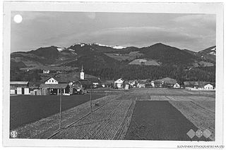
Gornji Dolič is a village in the Municipality of Mislinja in northern Slovenia. Traditionally the area was part of Carinthia and is now included in the Carinthia Statistical Region.
Završe is a dispersed settlement in the Municipality of Mislinja in northern Slovenia. The area was traditionally part of Carinthia. It is now included in the Carinthia Statistical Region.
Novo Tepanje is a settlement in the Municipality of Slovenske Konjice in eastern Slovenia. It lies on the regional road from Slovenske Konjice to Slovenska Bistrica on the left bank of Oplotnica Creek, a left tributary of the Dravinja River. The area is part of the traditional region of Styria. The municipality is now included in the Savinja Statistical Region.
Breg is a settlement on the left bank of the Sava River in the Municipality of Sevnica in central Slovenia. The area is part of the historical region of Styria. The municipality is now included in the Lower Sava Statistical Region. The settlement includes the hamlets of Gradišče, Jelše, and Zagradec.