Grafton Way (footpath)

Last updated

The Grafton Way approaching Greens Norton Grafton Way footpath to Greens Norton - geograph.org.uk - 389842.jpg
The Grafton Way approaching Greens Norton

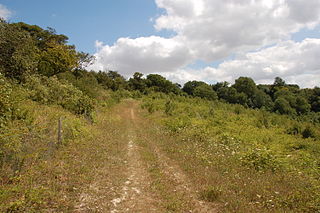
The Grafton Way is a 13-mile (21 km) [1] [2] (also measured at 11.5 miles or 18.5 kilometres) [3] footpath in Northamptonshire, England. It runs south east from Greens Norton to Cosgrove (or Wolverton [4] ), where it meets the Knightley Way. [2] It is named after the Dukes of Grafton, major land-owners in the area in the 18th and 19th centuries. [3]

Northamptonshire County of England

Northamptonshire, archaically known as the County of Northampton, is a county in the East Midlands of England. In 2015 it had a population of 723,000. The county is administered by Northamptonshire County Council and by seven non-metropolitan district councils. It is known as "The Rose of the Shires".

Greens Norton village in Northamptonshire, United Kingdom

Greens Norton is a village in South Northamptonshire, England, just over 1 mile (1.6 km) from Towcester. At the time of the 2001 census, the parish's population was 1,587 people, including Caswell and Duncote but the population reducing to 1,526 at the 2011 census.

Cosgrove, Northamptonshire village in Northamptonshire, England

Cosgrove is a village in Northamptonshire, England about 2 miles (3.2 km) north of Stony Stratford, 6 miles (9.7 km) north of central Milton Keynes and 12 miles (19.3 km) south of Northampton along the A508 road and 8 miles (12.9 km) south-east of Towcester along the A5 road. The River Tove passes to the east of the village flowing into the River Great Ouse just south, the latter marking the boundary with Buckinghamshire and Milton Keynes. The Grand Union Canal passes through the middle of the village.

It is recognised by the Long Distance Walkers Association and is marked on Ordnance Survey maps. [1]

Long Distance Walkers Association

The Long Distance Walkers Association (LDWA) is a British association whose aim is "to further the common interests of those who enjoy Long Distance Walking". It was established in 1972 by Chris Steer, Alan and Barbara Blatchford and has over 7,000 members. It defines a "long distance walk" as "any walk over 20 miles".

Ordnance Survey organisation that creates maps of Great Britain

Ordnance Survey (OS) is the national mapping agency of the United Kingdom which covers the island of Great Britain. Since 1 April 2015 part of Ordnance Survey has operated as Ordnance Survey Ltd, a government-owned company, 100% in public ownership. The Ordnance Survey Board remains accountable to the Secretary of State for Business, Energy and Industrial Strategy. It is also a member of the Public Data Group.

The walk starts in the centre of Greens Norton, and heads south east, skirting the south-west edge of Towcester. It passes through the hamlet of Pury End near Paulerspury, and crosses the A5 road (the ancient Watling Street) before passing the south-west of Yardley Gobion and the deserted village of Furtho to reach Cosgrove on the Grand Union Canal. Some descriptions of the walk stop here, others continue along the canal tow-path to Old Wolverton on the outskirts of Milton Keynes. [5]

Towcester town in Northamptonshire, England

Towcester is a market town in Northamptonshire, England. It is the administrative headquarters of the South Northamptonshire district council.

Pury End human settlement in United Kingdom

Pury End is a hamlet of approximately 100 houses in the civil parish of Paulerspury, near Towcester in South Northamptonshire, England. The Grafton Way footpath crosses through the village and runs down Carey's Road. The population of the parish, including Pury End, Plumpton and Paulerspury, was 1,018 in the 2011 census.

Paulerspury village in United Kingdom

Paulerspury is a civil parish and small village in Northamptonshire, England, within the district of South Northamptonshire. It is approximately 3 miles (5 km) south of Towcester and 8 miles (13 km) north of Milton Keynes along the A5 road. The parish also contains the hamlets or villages of Pury End, Pury Hill and Heathencote; at the time of the 2001 census, its population was 991 people. The 2011 population was 1,018.

Related Research Articles

Grand Union Canal part of the British canal system

The Grand Union Canal in England is part of the British canal system. Its main line starts in London and ends in Birmingham, stretching for 137 miles (220 km) with 166 locks. It has arms to places including Leicester, Slough, Aylesbury, Wendover and Northampton.

North Downs Way

The North Downs Way National Trail is a long-distance path in southern England, opened in 1978. It runs from Farnham to Dover, past Guildford, Dorking, Merstham, Otford and Rochester, along the Surrey Hills Area of Outstanding Natural Beauty (AONB) and Kent Downs AONB.

Stoke Bruerne village in United Kingdom

Stoke Bruerne is a small village and civil parish in South Northamptonshire, England about 10 miles (16 km) north of Milton Keynes and 7 miles (11 km) south of Northampton.

Cosgrove Hall (country house) country house in Cosgrove, Northamptonshire, United Kingdom

Cosgrove Hall is an early-18th-century Grade II listed country house in Cosgrove, Northamptonshire. It was built on the site of an earlier house by the Furtho family. It is not open to the public. It may have been built by John Lumley of Northampton. In the nineteenth century, the building belonged to John Christopher Manse. In May 1945, Queen Geraldine of Albania, the Queen consort to King Zog I of Albania, opened a fête at the hall. The building was badly damaged by fire in October 2016.

Jurassic Way

The Jurassic Way is a designated and signed long-distance footpath that connects the Oxfordshire town of Banbury with the Lincolnshire town of Stamford in England. It largely follows an ancient ridgeway traversing Britain; most of its 88-mile (142 km) route is in Northamptonshire on the Jurassic limestone ridge in the north of that county.

Wolverton railway station

Wolverton railway station serves northern Milton Keynes, Buckinghamshire, especially Wolverton, Stony Stratford, New Bradwell, and nearby villages in south Northamptonshire. The station is on the West Coast Main Line, about 52 miles (84 km) from Euston, between Milton Keynes Central and Northampton. The station is one of the six stations serving the Milton Keynes urban area.

The Midshires Way is a long-distance footpath and bridleway that runs for 230 miles (370 km) from the Chiltern Hills from near Bledlow in Buckinghamshire, through the Midlands counties of Northamptonshire, Leicestershire, Nottinghamshire and Derbyshire, to Stockport, Greater Manchester. It also links several other long-distance walking routes or trackways including The Ridgeway, the Pennine Bridleway and the Trans Pennine Trail.

Greensand Way

The Greensand Way is a long distance path of 108 miles (174 km) in southeast England, from Haslemere in Surrey to Hamstreet in Kent. It follows the Greensand Ridge along the Surrey Hills and Chart Hills. The route is mostly rural, passing through woods, and alongside fruit orchards and hop farms in Kent and links with the Stour Valley Walk near Pluckley in Kent. The trail was opened on 15 June 1980 and is jointly managed by Surrey and Kent Councils who fully updated it in 2012.

Staffordshire Way

The Staffordshire Way is a long distance walk in Staffordshire, England. The path links with the Cheshire Gritstone Trail, the Heart of England Way and the North Worcestershire Path.

Milton Keynes redway system

The Milton Keynes redway system is an over 200 mi (322 km) network of shared use paths for cyclists and pedestrians in Milton Keynes, Buckinghamshire, England. It is generally surfaced with red tarmac, and criss-crosses most of the city.

Swans Way (footpath) footpath and bridle route in England

Swan's Way is a long distance bridle route and footpath in Northamptonshire, Buckinghamshire and Oxfordshire, England. It runs 65 miles (105 km) from Salcey Forest, Northamptonshire to Goring-On-Thames, Oxfordshire. Although designed for horseriders by riders, it is a multi-use trail also available to walkers and cyclists.

Angles Way

The Angles Way is a long-distance footpath in England, close to the River Waveney and River Little Ouse and thus close to the Norfolk/Suffolk border between Great Yarmouth and Thetford.

To be distinguished from Elizabeth Woodville Primary School, Groby, Leicestershire.

Furtho village in the United Kingdom

Furtho is a deserted medieval village and former parish in South Northamptonshire, England. It is now part of Potterspury civil parish.

The Barrow Way is a long-distance trail in Ireland. It is 100 kilometres long and begins in Robertstown, County Kildare and ends in St Mullin's, County Carlow, following the course of the River Barrow and the Barrow Line of the Grand Canal through counties Kildare, Carlow, Kilkenny and Laois. It is typically completed in four days. It is designated as a National Waymarked Trail by the National Trails Office of the Irish Sports Council and is managed by Waterways Ireland.

Pendle Way

The Pendle Way is a Recreational Path in the South Pennines of England which encircles the borough of Pendle. It was officially opened in 1987. The circuit is 45 miles (72 km), and according to the Long Distance Walkers Association involves 1839 m (6033 ft) ascent reaching 557 m (1,827 ft) maximum height. Its attractions include historical associations with the seventeenth century Pendle Witches, connections with the Brontës, stonebuilt villages in the traditional style of East Lancashire and the South Pennines, relics of the weaving and lead mining industry, and limestone meadows and millstone grit moorland culminating in the ascent of Pendle Hill.

References

  1. 1 2 "Grafton Way". Long Distance Walkers Association . Retrieved 9 July 2016.
  2. 1 2 "The Grafton Way". Cosgrove and Furtho. Retrieved 9 July 2016.
  3. 1 2 "County Paths: Grafton Way". Northamptonshire Highways. Northamptonshire County Council. Archived from the original on 30 June 2016. Retrieved 9 July 2016.
  4. "Longer paths". South Northamptonshire Council. Retrieved 9 July 2016.
  5. "The Grafton Way" (PDF). South Northamptonshire Council. Leaflet with detailed map and route profile

Coordinates: 52°04′32″N0°50′54″W / 52.0755°N 0.8482°W / 52.0755; -0.8482

Geographic coordinate system Coordinate system

A geographic coordinate system is a coordinate system that enables every location on Earth to be specified by a set of numbers, letters or symbols. The coordinates are often chosen such that one of the numbers represents a vertical position and two or three of the numbers represent a horizontal position; alternatively, a geographic position may be expressed in a combined three-dimensional Cartesian vector. A common choice of coordinates is latitude, longitude and elevation. To specify a location on a plane requires a map projection.