
Grant County is a county located in the U.S. state of Washington. As of the 2010 census, the population was 89,120. The county seat is Ephrata, and the largest city is Moses Lake. The county was formed out of Douglas County in February 1909 and is named for U.S. President Ulysses S. Grant.

Coulee Dam is a town in Douglas, Grant, and Okanogan counties in the State of Washington. The Douglas County portion of Coulee Dam is part of the Wenatchee–East Wenatchee Metropolitan Statistical Area. The population was 1,098 as of the 2010 census.

"Roll On, Columbia, Roll On" is an American folk song written in 1941 by American folk singer Woody Guthrie, who popularized the song through his own recording of it. The song glamorized the harnessing of the Columbia River in the Pacific Northwest. The 11 hydroelectric dams built on the American stretch of the Columbia helped farms and industry, but their construction also permanently altered the character of the river.

The Columbia Basin Project in Central Washington, United States, is the irrigation network that the Grand Coulee Dam makes possible. It is the largest water reclamation project in the United States, supplying irrigation water to over 670,000 acres (2,700 km2) of the 1,100,000 acres (4,500 km2) large project area, all of which was originally intended to be supplied and is still classified as irrigable and open for the possible enlargement of the system. Water pumped from the Columbia River is carried over 331 miles (533 km) of main canals, stored in a number of reservoirs, then fed into 1,339 miles (2,155 km) of lateral irrigation canals, and out into 3,500 miles (5,600 km) of drains and wasteways. The Grand Coulee Dam, powerplant, and various other parts of the CBP are operated by the Bureau of Reclamation. There are three irrigation districts in the project area, which operate additional local facilities.
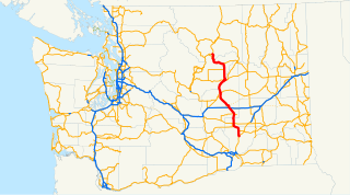
State Route 17 (SR 17) is a 136.67-mile-long (219.95 km) state highway serving the Columbia Plateau in the central region of the U.S. state of Washington. The highway travels through mostly rural areas of Franklin. Adams, Grant, Douglas, and Okanogan counties and is designated as part of the National Highway System between Mesa and Moses Lake and as the Coulee Corridor Scenic Byway between Othello and Coulee City for passing through the Grand Coulee. SR 17 begins in Mesa at an interchange with U.S. Route 395 (US 395) and travels north and intersects SR 26 near Othello before entering Moses Lake, where the highway intersects Interstate 90 (I-90) and travels as a partial expressway. SR 17 continues north, intersecting SR 28 in Soap Lake, through the Grand Coulee to a short concurrency with US 2 west of Coulee City. The highway turns northwest and crosses the Columbia River on the Columbia River Bridge at Bridgeport before ending at US 97 in Brewster at the southwestern edge of the Colville Indian Reservation.

Steamboat Rock State Park is a 3,522-acre (1,425 ha) Washington state park located near the north end of Banks Lake in the Grand Coulee. The park takes its name from the landscape's dominating feature, Steamboat Rock, a basalt butte that rises 800 feet (240 m) above the lake which nearly completely surrounds it. The butte's plateau covers more than 600 acres (240 ha) and was used by nomadic Native American tribes and by early settlers. During the last Ice Age, the monolith stood as an island in the new bed of the Columbia River where it had been diverted by ice dams. Once the dams burst creating massive floods and the Scablands, the Columbia returned to its original course, leaving Steamboat Rock as a prominent feature of the dry Grand Coulee.

The Kettle River is a 281-kilometre (175 mi) tributary of the Columbia River in southeastern British Columbia in Canada and northeastern Washington in the United States. Its drainage basin is 10,877 square kilometres (4,200 sq mi) large, of which 8,228 square kilometres (3,177 sq mi) are in Canada and 2,649 square kilometres (1,023 sq mi) in the United States. The indigenous name of the river in the Okanagan language is nxʷyaʔłpítkʷ (Ne-hoi-al-pit-kwu.)

Banks Lake is a 27-mile (43 km) long reservoir in central Washington in the United States.

State Route 174 (SR 174) is a 40.66-mile (65.44 km) long state highway that traverses Douglas, Grant and Lincoln counties in Washington. SR 174 begins at a junction with SR 17 in Leahy and travels eastward to Grand Coulee, near the Grand Coulee Dam, to intersect SR 155. From Grand Coulee, the roadway travels southeast to end at SR 21 northwest of Wilbur.
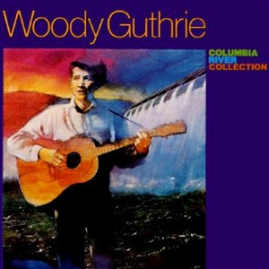
The Columbia River Collection, originally released as the Columbia River Ballads, is a compilation album of songs folksinger Woody Guthrie wrote during his visit to the U.S. states of Oregon and Washington in 1941. Guthrie traveled to these states on the promise of a part narrating a documentary about the construction of public works dams and other projects in the Pacific Northwest. The documentary never came to fruition, but 17 of the 26 songs he wrote during this period were compiled and released as this collection, including some of his most famous songs, such as "Roll on Columbia", "Grand Coulee Dam", "Hard Travelin’," and "Pastures of Plenty."
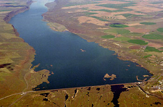
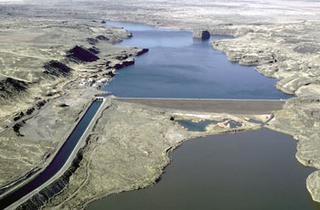
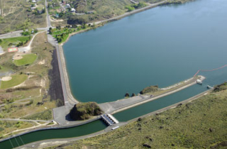
Dry Falls Dam is a rockfaced earthfill type dam in the U.S. state of Washington. Located in Grant County near Coulee City, it was built as part of the Bureau of Reclamation's Columbia Basin Project. Water from the Columbia River, impounded by Grand Coulee Dam, is pumped into Grand Coulee, a formerly dry canyon, through the short Feeder Canal. Grand Coulee's north end is sealed by North Dam and Dry Falls Dam stretches across the midsection of the Coulee. This allows the water pumped from the Columbia River to fill the upper Grand Coulee, creating a large equalizing reservoir known as Banks Lake. Water from the reservoir is fed into the irrigation project's Main Canal, which runs south from Dry Falls Dam to another reservoir called Billy Clapp Lake, formed by Pinto Dam.

Glacial Lake Columbia was the lake formed on the ice-dammed Columbia River behind the Okanogan lobe of the Cordilleran Ice Sheet when the lobe covered 500 square miles (1,300 km2) of the Waterville Plateau west of Grand Coulee in central Washington state during the Wisconsin glaciation. Lake Columbia was a substantially larger version of the modern-day lake behind the Grand Coulee Dam. Lake Columbia's overflow – the diverted Columbia River – drained first through Foster Coulee, and as the ice dam grew, through first Moses Coulee, and finally, the Grand Coulee.
Pinto Dam is a dam in Grant County, Washington.
Foster Coulee is a coulee in Douglas County, Washington. Like the larger Moses Coulee nearby, it was formed during the Missoula Floods at the end of the last ice age, some 14,000 years ago.
North Dam is an earth-fill embankment dam near the town of Grand Coulee in Grant County, Washington, United States. Construction of the dam began in 1946 and it was completed in 1951. Along with Dry Falls Dam about 22 mi (35 km) to the southeast, North Dam creates the reservoir Banks Lake within the ancient Grand Coulee riverbed. The lake serves as the equalizer reservoir of the Columbia Basin Project. Near the North Dam's left abutment is the entrance to the feeder canal of the project. The canal serves to either deliver water to the Pump-generating plant at Grand Coulee Dam or return water to Banks Lake from the same pumped-storage plant.

