
The Sacramento River is the principal river of Northern California in the United States, and is the largest river in California. Rising in the Klamath Mountains, the river flows south for 400 miles (640 km) before reaching the Sacramento–San Joaquin River Delta and San Francisco Bay. The river drains about 26,500 square miles (69,000 km2) in 19 California counties, mostly within the fertile agricultural region bounded by the Coast Ranges and Sierra Nevada known as the Sacramento Valley, but also extending as far as the volcanic plateaus of Northeastern California. Historically, its watershed has reached as far north as south-central Oregon where the now, primarily, endorheic (closed) Goose Lake rarely experiences southerly outflow into the Pit River, the most northerly tributary of the Sacramento.

Trinity County is a county in the northwestern part of the state of California. As of the 2010 census, the population was 13,786, making it the fourth least-populous county in California. The county seat and largest community is Weaverville.

Mount Whitney is the tallest mountain in California, as well as the highest summit in the contiguous United States and the Sierra Nevada—with an elevation of 14,505 feet (4,421 m). It is in Central California, on the boundary between California's Inyo and Tulare counties, 84.6 miles (136.2 km) west-northwest of the lowest point in North America at Badwater Basin in Death Valley National Park at 282 ft (86 m) below sea level. The west slope of the mountain is in Sequoia National Park and the summit is the southern terminus of the John Muir Trail which runs 211.9 mi (341.0 km) from Happy Isles in Yosemite Valley. The east slope is in the Inyo National Forest in Inyo County.

The Klamath Mountains are a rugged and lightly populated mountain range in northwestern California and southwestern Oregon in the western United States. They have a varied geology, with substantial areas of serpentinite and marble, and a climate characterized by moderately cold winters with very heavy snowfall and warm, very dry summers with limited rainfall, especially in the south. As a consequence of the geology and soil types, the mountains harbor several endemic or near-endemic trees, forming one of the largest collections of conifers in the world. The mountains are also home to a diverse array of fish and animal species, including black bears, large cats, owls, eagles, and several species of Pacific salmon. Millions of acres in the mountains are managed by the United States Forest Service. The northernmost and largest sub-range of the Klamath Mountains are the Siskiyou Mountains.

San Jacinto Peak is the highest peak of the San Jacinto Mountains, and of Riverside County, California. It lies within Mount San Jacinto State Park. Naturalist John Muir wrote of San Jacinto Peak, "The view from San Jacinto is the most sublime spectacle to be found anywhere on this earth!"

The Trinity River is a major river in northwestern California in the United States, and is the principal tributary of the Klamath River. The Trinity flows for 165 miles (266 km) through the Klamath Mountains and Coast Ranges, with a watershed area of nearly 3,000 square miles (7,800 km2) in Trinity and Humboldt Counties. Designated a National Wild and Scenic River, along most of its course the Trinity flows swiftly through tight canyons and mountain meadows.

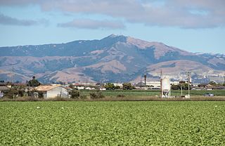
Junipero Serra Peak is the highest mountain in the Santa Lucia Mountains of California. It is also the highest peak in Monterey County. It is named after Franciscan Friar Junípero Serra, founder of the California Missions.

Trinity Lake, previously called Clair Engle Lake, is an artificial lake on the Trinity River formed by the Trinity Dam and located in Trinity County, California, United States. The dam was built by the U.S. Bureau of Reclamation. The lake's capacity is 2,447,650 acre⋅ft (3,019.13 GL), making it one of the largest reservoirs in California. The lake's surface is at 2,370 ft (720 m) above MSL. Trinity Lake captures and stores water for the Central Valley Project, which provides the Central Valley with water for irrigation and produces hydroelectric power. This lake is known for its many small arms, glassy inlets, and great water-skiing conditions.
Matterhorn Peak is located in the Sierra Nevada, in the western U.S. state of California, at the northern boundary of Yosemite National Park. At 12,285 feet (3,744 m) elevation, it is the tallest peak in the craggy Alps-like Sawtooth Ridge and the northernmost 12,000-foot (3,700 m) peak in the Sierra Nevada. The peak also supports the Sierra's northernmost glacier system. It was named after the Matterhorn in the Alps. Matterhorn Peak is quite near to Twin Peaks, and just north, of Whorl Mountain.

The Trinity Alps Wilderness is a 525,627-acre (2,130 km2) designated wilderness located in northern California, roughly between Eureka and Redding. It is jointly administered by Shasta-Trinity, Klamath, and Six Rivers National Forests. About 4,623 acres (18.71 km2) are administered by the Bureau of Land Management. The wilderness is located in the Salmon and Scott Mountains, subranges of the Klamath Mountains region. The high, granitic and ultramafic peaks of the eastern half of the wilderness area are known as the Trinity Alps. Granite peaks at the core of the area are known as the White Trinities, reddish ultramafic peaks in the southeast are known as the Red Trinities, and the forested mountains in the western half of the wilderness are known as the Green Trinities.
Fremont Peak is a summit in the Gabilan Range, one of the mountain ranges paralleling California's central coast. The peak affords clear views of the Salinas Valley, Monterey Bay, the southern part of the Santa Clara Valley, and surrounding mountain ranges. It is located on Rocky Ridge, 11 miles (18 km) northeast of Salinas, California.

Mount Linn, at 8,098 feet (2,468 m), is the easternmost summit of South Yolla Bolly Mountain, and is located in the Yolla Bolly Mountains range of the southern Klamath Mountains System, in Tehama County, northwestern California.

Mount Eddy is the highest peak of the Trinity Mountains, a mountain range of the Klamath Mountains System, located in Siskiyou County, and Trinity County in northern California.

Salmon Mountain is located in the Klamath Mountains of California and is the highest point in Humboldt County. The area is protected in the Trinity Alps Wilderness on the Six Rivers National Forest. The mountain is high enough to receive snowfall in the winter.

Granite Chief is a mountain located in the Sierra Nevada near Lake Tahoe. The mountain rises to an elevation of 9,010 feet (2,746 m) and receives consistent heavy snowfall during the winter months.

Florence Peak is a mountain located on the Great Western Divide, a sub-range of the southern Sierra Nevada of California. It is located about 6 miles (9.7 km) southeast of the community of Silver City and 4.5 miles (7.2 km) from the roads end at Mineral King. It marks the southern boundary of Sequoia National Park. On the summit the Sequoia-Kings Canyon Wilderness, the John Krebs Wilderness and Golden Trout Wilderness meet.

The Russian Wilderness is a wilderness area of 12,000 acres (49 km2) located approximately 65 miles (105 km) northeast of Eureka in northern California. It is within the Klamath National Forest in Siskiyou County and is managed by the US Forest Service. It was added to the National Wilderness Preservation System when the US Congress passed the California Wilderness Act of 1984.

Mount Hōō is located in the western portion of Yamanashi Prefecture, Japan. Because the mountain has three peaks, it is also called Hōō Sanzan (鳳凰三山). It is in Minami Alps National Park and is one of the 100 Famous Japanese Mountains.

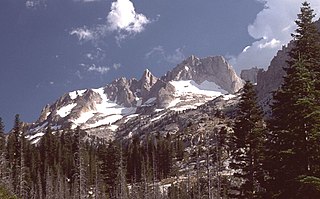
Thompson Peak is a mountain in Trinity County, California. At 9,001 feet, it is the highest peak in the Trinity Alps Wilderness, and the second highest in Northern California west of the Cascades.


