
Cambridgeshire is a county in the East of England, bordering Lincolnshire to the north, Norfolk to the north-east, Suffolk to the east, Essex and Hertfordshire to the south, and Bedfordshire and Northamptonshire to the west. The city of Cambridge is the county town. Modern Cambridgeshire was formed in 1974 as an amalgamation of the counties of Cambridgeshire and Isle of Ely and Huntingdon and Peterborough, the former covering the historic county of Cambridgeshire and the latter covering the historic county of Huntingdonshire and the Soke of Peterborough, historically part of Northamptonshire. It contains most of the region known as Silicon Fen.
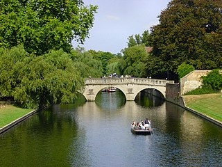
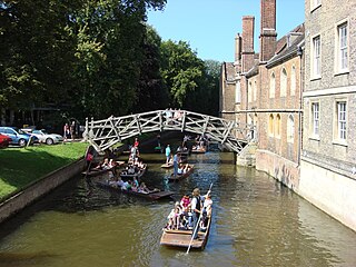
The River Cam is the main river flowing through Cambridge in eastern England. After leaving Cambridge, it flows north and east into the Great Ouse to the south of Ely at Pope's Corner. The Great Ouse connects the Cam to the North Sea at King's Lynn: The total distance from Cambridge to the sea is about 40 mi (64 km) and is navigable for punts, small boats, and rowing craft. The Great Ouse also connects to England's canal system via the Middle Level Navigations and the River Nene. In total, the Cam runs for around 69 kilometres (43 mi) from its furthest source to its confluence with the Great Ouse.

Grantchester is a village and civil parish on the River Cam or Granta in South Cambridgeshire, England. It lies about two miles (3 km) south of Cambridge.

The Abingtons are a community in South Cambridgeshire consisting of two villages: Little Abington and Great Abington, about 7 miles (11 km) south east of Cambridge.
Cambridge ( ) is a hamlet in the district of Stroud, in the county of Gloucestershire, England. It lies on the A38 road between Bristol and Gloucester. It is about 3 miles from Dursley and about 11 miles from Gloucester.

Little Shelford is a village located to the south of Cambridge, in the county of Cambridgeshire, in eastern England. The River Granta lies between it and the larger village of Great Shelford, and both are served by Shelford railway station, which is on the West Anglia Main Line from Cambridge to London Liverpool Street. The village has one pub, The Navigator, on the High Street.

Linton is a village and civil parish in Cambridgeshire, England, on the border with Essex. The village is approximately 8 miles (13 km) southeast from the city and county town of Cambridge. The A1307 passes through the village.

The Henley Boat Races are a series of rowing races between men's and women's lightweight crews representing the University of Oxford and the University of Cambridge.
The Blue Boat is the highest level boat representing the University of Oxford or the University of Cambridge in the universities' annual rowing clashes on the River Thames: The Boat Race and Women's Boat Race. As of 2016, the women's first VIII clash also takes places on the River Thames, along with their male counterparts. Lightweight crews of both genders race annually at the Henley Boat Races.

Babraham is a village and civil parish in the South Cambridgeshire district of Cambridgeshire, England, about 6 miles (9.7 km) south-east of Cambridge on the A1307 road.
Bartlow is a small village and civil parish in the South Cambridgeshire district of Cambridgeshire, England, about 12 miles (19 km) south-east of Cambridge and 7 miles (11 km) west of Haverhill in Suffolk. The River Granta runs through the village.

Castle Hill is a knoll in Cambridge, England, located in the Castle ward of the city. Cambridgeshire County Council's headquarters, Shire Hall, are located directly adjacent to Castle Hill.

Whittlesford is a village in Cambridgeshire, England, and also the name of an old hundred. The village is situated on the Granta branch of the River Cam, seven miles south of Cambridge. Whittlesford Parkway railway station serves the village.
Silver Street is located in the southwest of central Cambridge, England. It links Queen's Road to the west with Trumpington Street to the east. The road continues west out of central Cambridge as Sidgwick Avenue.
Hildersham is a small village 8 miles to the south-east of Cambridge, England. It is situated just off the A1307 between Linton and Great Abington on a tributary of the River Cam known locally as the River Granta. The parish boundary extends from the Roman Road, known in medieval times as Wool Street, north of the village, to the border with Essex to the south.The village sign was designed by Mrs.D.E.Arkright who along with her husband Mr. R.B.Arkright MBE lived in the village for over 40 years.
This page is based on this
Wikipedia article Text is available under the
CC BY-SA 4.0 license; additional terms may apply.
Images, videos and audio are available under their respective licenses.


