
Bulgaria is a country situated in Southeast Europe and occupies the eastern quarter of the Balkan peninsula, being the largest country within its geographic boundaries. It is bordering Romania to the north, Serbia and North Macedonia to the west, Greece and Turkey to the south, and the Black Sea to the east. The northern border with Romania follows the river Danube until the city of Silistra. The land area of Bulgaria is 110,994 square kilometres (42,855 sq mi), slightly larger than that of Iceland or the U.S. state of Tennessee. Considering its relatively small size, Bulgaria has a great variety of topographical features. Even within small parts of the country, the land may be divided into plains, plateaus, hills, mountains, basins, gorges, and deep river valleys. The geographic center of Bulgaria is located in Uzana.

The Balkans, also known as the Balkan Peninsula, is a geographic area in southeastern Europe with various geographical and historical definitions. The region takes its name from the Balkan Mountains that stretch throughout the whole of Bulgaria. The Balkan Peninsula is bordered by the Adriatic Sea in the northwest, the Ionian Sea in the southwest, the Aegean Sea in the south, the Turkish Straits in the east, and the Black Sea in the northeast. The northern border of the peninsula is variously defined. The highest point of the Balkans is Mount Musala, 2,925 metres (9,596 ft), in the Rila mountain range, Bulgaria.

North Macedonia is a country situated in southeastern Europe with geographic coordinates 41°50′N22°00′E, bordering Kosovo and Serbia to the north, Bulgaria to the east, Greece to the south and Albania to the west. The country is part of the wider region of Macedonia and makes up most of Vardar Macedonia. The country is a major transportation corridor from Western and Central Europe to Southern Europe and the Aegean Sea. North Macedonia is a landlocked country but has three major natural lakes: Lake Ohrid, Lake Prespa and Lake Dojran. It has a water area of 857 km2, while its land area is 24,856 km2.
The Ardennes, also known as the Ardennes Forest or Forest of Ardennes, is a region of extensive forests, rough terrain, rolling hills and ridges primarily in Belgium and Luxembourg, extending into Germany and France. Geologically, the range is a western extension of the Eifel; both were raised during the Givetian age of the Devonian, as were several other named ranges of the same greater range.

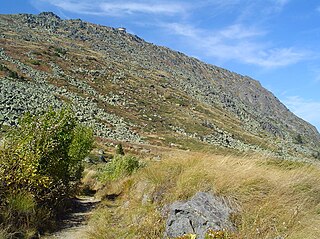
The Rhodopes are a mountain range in Southeastern Europe, with over 83% of its area in southern Bulgaria and the remainder in Greece. Golyam Perelik is its highest peak at 2,191 meters (7,188 ft). The mountain range gives its name to the terrestrial ecoregion Rodope montane mixed forests that belongs in the temperate broadleaf and mixed forests biome and the Palearctic realm. The region is particularly notable for its karst areas with their deep river gorges, large caves and specific sculptured forms, such as the Trigrad Gorge.

The Balkan mountain range is a mountain range in the eastern part of the Balkan Peninsula in Southeastern Europe. The range is conventionally taken to begin at the peak of Vrashka Chuka on the border between Bulgaria and Serbia. It then runs for about 560 kilometres (350 mi), first in a south-easterly direction along the border, then eastward across Bulgaria, forming a natural barrier between the northern and southern halves of the country, before finally reaching the Black Sea at Cape Emine. The mountains reach their highest point with Botev Peak at 2,376 metres (7,795 ft).

Vitosha, the ancient Scomius or Scombrus, is a mountain massif, on the outskirts of Sofia, the capital of Bulgaria. Vitosha is one of the symbols of Sofia and the closest site for hiking, alpinism and skiing. Convenient bus lines and rope ways render the mountain easily accessible. Vitosha has the outlines of an enormous dome. The territory of the mountain includes Vitosha nature park that encompasses the best known and most frequently visited parts. The foothills of Vitosha shelter resort quarters of Sofia; Knyazhevo quarter has mineral springs. Vitosha is the oldest nature park in the Balkans. The mountain emerged as a result of volcanic activity and has been subsequently shaped by the slow folding of the granite rock layers and a series of gradual uplifts of the area. It appears dome shaped at first sight, but the mountain, 19 km long by 17 km wide, actually consists of concentric denudational plateaus rising in tiers one above the other. Vitosha is separated into four main parts whose main ridges gather at a crown known as Cherni Vrah. This is the highest point of the mountain at 2290 m and is one of 12 peaks of Vitosha over 2000 m in height. It is the highest massif of Srednogorie mountain chain system, together with Sredna gora, Plana (mountain), Lyulin Mountain, Greben (mountain), Viskyar Mountain, etc. They all are a result of the folding of the earth layers through the Mesozoic, causing also magma sheet-like intrusion that has been injected between layers of sedimentary rock. The laccolithic domed form of Vitosha is a typical example.

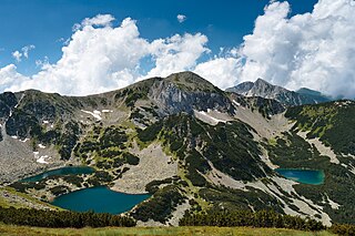
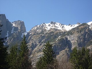
Rila is the highest mountain range of Bulgaria, the Balkan Peninsula and Southeast Europe. It is situated in southwestern Bulgaria and forms part of the Rila–Rhodope Massif. The highest summit is Musala at an altitude of 2,925 m which makes Rila the sixth highest mountain range in Europe after the Caucasus, the Alps, Sierra Nevada, the Pyrenees and Mount Etna, and the highest one between the Alps and the Caucasus. It spans a territory of 2,629 km2 with an average altitude of 1487 m. The mountain is believed to have been named after the river of the same name, which comes from the Old Bulgarian verb "рыти" meaning "to grub".
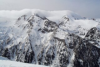
The Pirin Mountains are a mountain range in southwestern Bulgaria, with Vihren at an altitude of 2,914 m being the highest peak.
Pirin National Park, originally named Vihren National Park, encompasses the larger part of the Pirin Mountains in southwestern Bulgaria, spanning an area of 403.56 km2 (155.82 sq mi).
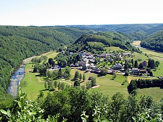
Batak is a town in Pazardzhik Province, Southern Bulgaria, not far from the town of Peshtera. It is the administrative centre of the homonymous Batak Municipality. As of December 2009, the town has a population of 3,498 inhabitants.

The military macaw is a large parrot and a medium-sized macaw that gets its name from its predominantly green plumage resembling a military parade uniform. It is native to forests of Mexico and South America and though considered vulnerable in the wild, it is still commonly found in the pet trade industry.

Aleksinac is a town and municipality located in the Nišava District of southern Serbia. According to 2011 census, the town has a population of 17,978 inhabitants, while the municipality has 51,863 inhabitants.
Bistrishko Branishte is a nature reserve in the Vitosha Nature Park on Vitosha Mountain in Bulgaria.

The Belgrade offensive or the Belgrade strategic offensive operation was a military operation during World War II in Yugoslavia in which Belgrade was liberated from the German Wehrmacht through the joint efforts of the Soviet Red Army, Yugoslav Partisans, and the Bulgarian Army. Soviet forces and local militias launched separate but loosely cooperative operations that undermined German control of Belgrade and ultimately forced a retreat. Martial planning was coordinated evenly among command leaders, and the operation was largely enabled through tactical cooperation between Josip Broz Tito and Joseph Stalin that began in September 1944. These martial provisions allowed Bulgarian forces to engage in operations throughout Yugoslav territory, which furthered tactical success while increasing diplomatic friction.
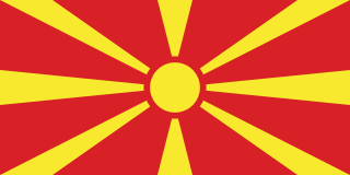
North Macedonia, officially the Republic of North Macedonia, is a country in Southeast Europe. It gained independence in 1991 as one of the successor states of Yugoslavia. It is a landlocked country bordering Kosovo to the northwest, Serbia to the north, Bulgaria to the east, Greece to the south, and Albania to the west. It constitutes approximately the northern third of the larger geographical region of Macedonia. Skopje, the capital and largest city, is home to a quarter of the country's 1.83 million population. The majority of the residents are ethnic Macedonians, a South Slavic people. Albanians form a significant minority at around 25%, followed by Turks, Romani, Serbs, Bosniaks, Aromanians and a few other minorities.

Strandzha Nature Park is the largest protected area in Bulgaria spanning a territory of 1,161 square kilometres (448 sq mi) in the Strandzha Mountain in the extreme south-eastern corner of the country on the border with Turkey. It was established on 25 January 1995 to protect ecosystems and biodiversity of European importance, as well as the traditional cultural, historical and folklore heritage of the region. The altitude varies from 710 metres (780 yd) on Gradishte Peak to 0 metres (0 yd) at the Black Sea coast with average length of 50 kilometres (31 mi) from west to east and 20 kilometres (12 mi) from north to south.
Rila Monastery Nature Park is one of the largest nature parks in Bulgaria, spanning a territory of 252.535 km2 (97.504 sq mi) in the western part of the Rila mountain range at an altitude between 750 and 2,713 metres. It is in Rila Municipality, Kyustendil Province and includes forests, mountain meadows, alpine areas and 28 glacial lakes. With a little more than 1 million visitors, it is the second-most visited nature park in the country, after Vitosha Nature Park.

Stara Reka is one of the nine nature reserves in the Central Balkan National Park in central Bulgaria. Stara Reka was established on 19 March 1981 to protect the unique ecosystems of the Balkan Mountains. It spans an area of 1974.7 hectares, or 19.747km2.
Braničevo Fortress is a medieval Serbian fortress whose remains are situated in the village of Kostolac, in Serbia, about 130km east of Belgrade and 24 km from northeast of Požarevac. It consists of two Medieval fortified structures located in Mali Grad and Veliki Grad, on the right bank of the Danube and above Dunavac and the Mlava River.