Worcester Agricultural Fairgrounds was a 20-acre (80,000 m²) site in Worcester, Massachusetts in the 19th century. It was bounded by Highland Street (north), Sever Street (east), Cedar Street or William Street, and Agricultural Street (west). The grounds were just east of the large public park called Elm Park. Today, the former fairgrounds property contains a grid of streets, and many homes and businesses, including Becker College.

Oak Hill is one of thirteen villages of the city of Newton in Middlesex County, Massachusetts, USA.
Union Hill, also referred to as Grafton Hill and originally known as Sagatabscot Hill is a neighborhood in Worcester, Massachusetts. Located in the southeastern part of the city and anchored by Grafton Street and Providence Street, Union Hill is one of the seven major hills of the city. According to the city government, the seven hills are Hancock, Bancroft, Newton, Green, Chandler, Union (Sagatabscot) and Mt. St. James .

The John H. Chafee Blackstone River Valley National Heritage Corridor is a National Heritage Corridor dedicated to the history of the early American Industrial Revolution, including mill towns stretching across 24 cities and towns near the river's course in Worcester County, Massachusetts and Providence County, Rhode Island. It makes up a historical area in the Blackstone Valley and is named for the late US Senator from Rhode Island John Chafee. In 2014, the Blackstone River Valley National Historical Park was created out of a smaller portion of the National Heritage Corridor. Both units now exist as cooperative entities. The organization is headquartered at the building in Woonsocket Depot Square which is located at 1 Depot Square, Woonsocket, RI 02895.

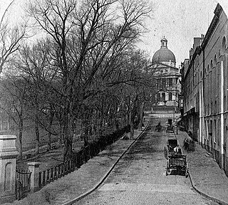
Park Street is a small but historic road in the center of Boston, Massachusetts. It begins at the top of Beacon Hill, at the intersection of Beacon Street, where it is lined up with the front of the Massachusetts State House. It then spills down the hill toward Tremont Street, with Boston Common to its west.
This is a list of historic sites in Framingham, Massachusetts. There are several notable historic sites in Framingham, according to the Framingham Historical Society. This local society asserts:
While there are many historic spaces in Framingham, the Centre Common is the focal point for the town's past. Three of the town's most historic buildings on the Centre Common face "demolition by neglect." The Village Hall, the Edgell Memorial Library, and the Old Academy building not only house over 10,000 artifacts spanning four centuries of the town's history, but they are symbols of Framingham's commitment to educational excellence, civic engagement, and community pride.
Worcester Country Club is a private country club and golf course in Worcester, Massachusetts. The course hosted the first Ryder Cup in 1927, and was the site of the 1925 U.S. Open, which was won by Willie Macfarlane. Worcester also hosted the 1960 U.S. Women’s Open. It was the first, and currently only one of three golf courses in the United States to host the men's and women's U.S. Open Championships and the Ryder Cup. For over half a century Worcester was the only club to have hosted all three events until 2014 when Pinehurst hosted its first U.S. Women’s Open. Hazeltine made it an elite group of three upon its host of the 2016 Ryder Cup, but notably, Hazeltine is not a classic course. Worcester also hosted the first ever U.S. Open qualifying round in 1924. The club is tied with Oyster Harbors for hosting the most Massachusetts Opens (7) and has also hosted 7 Massachusetts Amateur Championships. Worcester is one of a few private clubs in the United States that has a bowling alley in the men’s locker room.

The Church Green is a town common in Taunton, Massachusetts. It is a triangular-shaped parcel of land located at the intersection of Summer Street and Dean Street. It has distinctive Veterans Memorials dedicated to both Vietnam Veterans and Global War on Terrorism Veterans. These memorials feature seven flags that are in a V shape, a fountain, a brick garden, reflection benches, the Vietnam Veterans Memorial and the Global War on Terrorism Memorial.
The West River, in the US state of Massachusetts, is a 13.4-mile-long (21.6 km) tributary of the Blackstone River.

Still River is a village located on the west side of the town of Harvard, Worcester County, Massachusetts, United States.

Worcester Memorial Auditorium is a multi-purpose arena located at Lincoln Square in Worcester, Massachusetts. Built in 1933, as a World War I War memorial in the form of a multi-purpose hall, the Auditorium has a 116-foot-wide (35 m), proscenium. It was added to the National Register of Historic Places in 1980 as part of the Institutional District.

Morrissey Boulevard is a six-lane divided coastal road in the Dorchester neighborhood of Boston, Massachusetts. It is owned and maintained by the Massachusetts Department of Conservation and Recreation (DCR).

University Park, also called Crystal Park, is a public park in the Main South neighborhood of Worcester, Massachusetts. The 13-acre (53,000 m2) park was acquired by the city from 1887 to 1889, costing nearly 62,000 dollars. It is located across Main Street from Clark University, thus the name. University Park Campus School, a local nearby public high school founded with help from Clark, is named after the park.
Boulevard Park was a ballpark located in Worcester, Massachusetts, United States. It served as the home park of the Worcester Busters, Worcester Boosters and Worcester Panthers. It lasted approximately two decades, opening on April 19, 1906 and burning in 1926. The capacity of the ballpark was 3,500.
Commerce Bank Field at Foley Stadium is a historic sports venue in Worcester, Massachusetts. It was built in 1927 and was renovated in 2007. It is primarily a stadium used for high school football teams in the city and is owned and operated by the City of Worcester.
Kelley Square is a square located in Worcester, Massachusetts at the corner of Green and Harding Streets. It is named for Sgt. Cornelius F. Kelley, who was killed in Verdun, France on 13 October, 1918. Due to the convergence of multiple roads in the area, it has made the state's list of the most dangerous intersections in the state.
Faggot Hill is a summit in Worcester County, Massachusetts, United States. It stands 1.4 miles (2.3 km) from the town center of Boylston, Massachusetts. With an elevation of 554 feet (169 m), Faggot Hill is the 969th highest summit in Massachusetts.
Veterans Memorial Stadium is a multipurpose outdoor stadium in Quincy, Massachusetts. Built from 1937-1938 under the Works Progress Administration, it seats 3,000 spectators for football, soccer and lacrosse. The stadium underwent a $1.2 million renovation in 2006, including accessibility improvements and new synthetic turf as well as making the stadium usable as a lacrosse and soccer field. It is the home to both Quincy High School and North Quincy High School. With the historic main grandstand and iconic brick walls, it is known affectionately as "The Stadium" to student athletes throughout the City of Quincy. The grounds have most notably held the annual intracity Thanksgiving Day Game between QHS and NQHS, dubbed by SI.com as one of the best in America, since 1932.
The Putnam House is a colonial home at 211 Putnam Hill Road, Sutton, Massachusetts built in 1737.


