
Llangefni is the county town of Anglesey in Wales and contains the principal offices of the Isle of Anglesey County Council. United Kingdom Census 2011 recorded Llangefni's population as 5,116 people, making it the second largest settlement in the county. The community includes the village of Rhosmeirch.

Aberffraw is a small village and community on the south west coast of the Isle of Anglesey, in Wales, by the west bank of the Afon Ffraw. Access by road is by way of the A4080 and the nearest rail station is Bodorgan. The community includes Soar and Dothan.
Pentraeth is a village and community on the island of Anglesey, North Wales, at grid reference SH523786. The Royal Mail postcode begins LL75. The community population taken at the 2011 census was 1,178. The village itself having a population of 557.

Penmynydd, meaning top of the mountain in Welsh, is a village and community on Anglesey, Wales. It is known for being the birthplace of the Tudors of Penmynydd, which became the House of Tudor. The population according to the United Kingdom Census 2011 was 465. The community includes the village of Star.

Valley is a village, community, and former electoral ward near Holyhead on the west coast of Anglesey, North Wales. The population during the 2001 census was 2,413, decreasing to 2,361 at the 2011 census.

Rhosneigr is a village in the south-west of Anglesey, north Wales. It is situated on the A4080 road some 10 km south-east of Holyhead, and is on the Anglesey Coastal Path. From the clock at the centre of the village can be seen RAF Valley and Mynydd Twr. The major towns of Holyhead and Llangefni and the city of Bangor are all within easy travelling distance. It is the most expensive place to live in Anglesey in terms of house prices.

Trearddur or Trearddur Bay is a village, seaside resort and community south of Holyhead on the west coast of Holy Island off the north-west coast of Anglesey in Wales. The community includes the small settlement of Penrhosfeilw.

Llanllyfni is a village and a community in Gwynedd, Wales. It is in the historic county of Caernarfonshire. The community consists of the villages of Drws-y-coed, Nantlle, Nasareth, Nebo, Penygroes, Talysarn and the village of Llanllyfni itself. Penygroes, Llanllyfni and Talysarn are almost conjoined. As an electoral ward the 2011 census recorded a population of 1256. It is a largely Welsh-speaking village as 85% of the villagers speak Welsh as their first language. The community covers 43 square kilometres.
Gaerwen is a village on the island of Anglesey in the community of Llanfihangel Ysgeifiog. It is located in the south of the island 4 miles (6.4 km) west of Llanfairpwllgwyngyll and 4 miles (6.4 km) southeast of Llangefni. The A5 runs through the village, and the A55 runs just a few hundred metres north. According to the 2011 Census Gaerwen is now listed by the Office for National Statistics as Llanfihangel Ysgeifiog. The population of the community is 1,551. Gaerwen and Pentre Berw, Llangaffo are trio villages.

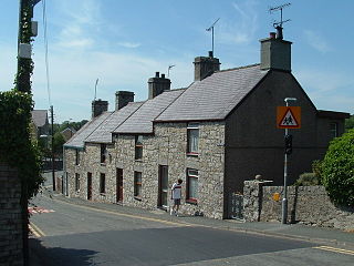
Bodffordd is a village and community in central Anglesey, Wales. As of the 2011 census, the community's population was 960. The community includes the hamlets of Trefor, Heneglwys and Bodwrog.

Llanidan is a community in south-west Anglesey, Wales which includes the village of Brynsiencyn. The parish is along the Menai Strait, about 4 miles north-east of Caernarfon. The parish church of St Nidan is near the A4080 highway, a little to the east of Brynsiencyn. The ruins of an earlier parish church survive.

Llanrug is a large village and community in Gwynedd, north-west Wales. It lies about 4 miles (6.4 km) to the east of Caernarfon, 7 miles (11 km) south of Bangor and 3 miles (4.8 km) northwest of Llanberis. It is the largest populated village in the Arfon area of Gwynedd, Wales. The old name of the village was Llanfihangel-y-Rug, derived from Eglwys Sant Mihangel, which is situated about half a mile west of the village. It has a Welsh-speaking community of approximately 88%, the highest in Wales, and a population of 2,911.

Anglesey is an island off the north-west coast of Wales. It forms a principal area known as the Isle of Anglesey, that includes Holy Island across the narrow Cymyran Strait and some islets and skerries. Anglesey island, at 260 square miles (673 km2), is the largest in Wales, the seventh largest in Britain, largest in the Irish Sea and second most populous there after the Isle of Man. Isle of Anglesey County Council covers 276 square miles (715 km2), with a 2011 census population of 69,751, including 13,659 on Holy Island. The Menai Strait to the mainland is spanned by the Menai Suspension Bridge, designed by Thomas Telford in 1826, and the Britannia Bridge, built in 1850 and replaced in 1980. The largest town is Holyhead on Holy Island, whose ferry service with Ireland handles over two million passengers a year. The next largest is Llangefni, the county council seat. From 1974 to 1996 Anglesey was part of Gwynedd. Most full-time residents are habitual Welsh speakers. The Welsh name Ynys Môn is used for the UK Parliament and Senedd constituencies. The postcodes are LL58–LL78. It is also a historic county of Wales.

Llanfair-yn-Neubwll is a village and community on the Isle of Anglesey in the north west of Wales. The community includes the villages of Llanfihangel yn Nhowyn and Caergeiliog, and had a population of 1,688, increasing to 1,874 at the 2011 census. The community is heavily connected to the nearby Royal Air Force airfield, RAF Valley, established on Tywyn Trewan during the Second World War, and still in use. Due to the airfield, Llanfair-yn-Neubwll is one of the most anglicised of the communities on Anglesey.

C.P.D. Gwalchmai is a football club from Gwalchmai in Wales. They play in the North Wales Coast West Football League Premier Division and with their home games at Maes Meurig. The club is one of Anglesey's most successful football teams, winning nine top division Anglesey League title, one Gwynedd League title and major success in different cup competitions reaching 49 finals, winning 26, including North Wales Coast Football Association Junior Cup on three occasions.

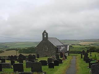
St Twrog's Church is a small rural church at Bodwrog in Anglesey, North Wales. Built in the late 15th century in a medieval style, some alterations have been made but much of the original structure still remains. It has two 15th-century doorways and some 15th-century windows. The bull's head decoration used on the church denotes a connection with the Bulkeleys of Beaumaris, a prominent north Wales family over several centuries. Set in a remote part of the countryside in the middle of Anglesey, it is dedicated to St Twrog, who was active in the late 5th and early 6th centuries. The church's tithes were paid for at least two hundred years to Jesus College, Oxford, which has historically strong links with Wales, and the college at one point built a house for the priest who served St Twrog's and a neighbouring parish.

Llaneilian is a village and community in the Welsh county of Anglesey. It is located in the north east of the island, 2.2 miles (3.5 km) east of Amlwch, 16.5 miles (26.6 km) north west of Menai Bridge and 12.5 miles (20.1 km) north of Llangefni. The community includes the villages and hamlets of Dulas, Llaneilian, Pengorffwysfa, Cerrig Man and Penysarn, Gadfa and Nebo, and at the 2001 census had a population of 1,192, decreasing slightly to 1,186 at the 2011 Census. The parish is crowned by its hill, Mynydd Eilian, a HuMP, popular with walkers and ramblers, and its beach, Traeth Eilian, which is popular with holidaymakers and for watersport activities. At the north easternmost point is Point Lynas,, while Ynys Dulas lies off the North East coast of the island, east of Dulas Bay.
Llanfaethlu is a village in the north west of Anglesey, in north-west Wales. The community population taken at the 2011 Census was 553. The village takes its name from the Church of Saint Maethlu. The community includes Llanfwrog.

Rhosybol is a village in Anglesey, Wales. The community population at the 2011 census was 1,078. Located 2.5 miles (4.0 km) south of the town of Amlwch, the village is close to both Llyn Alaw, the largest body of water on the island, and Parys Mountain, the site of the historic copper mines which lies just to the north. It is to the mines that the village owes its existence as it was one of several built to house the miners. During the 1960s noted painter Kyffin Williams produced an oil painting of the village.


