
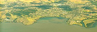
Wyong is a town on the Central Coast of New South Wales, Australia. It is located approximately 63 km SSW of Newcastle and 93 km NNE of the state capital Sydney. Established in 1888, it is one of the two administrative centres for the Central Coast Council local government area.
Dapto is a suburb of Wollongong in the Illawarra region of New South Wales, Australia, located on the western side of Lake Illawarra and covering 7.15 square kilometres (2.76 sq mi). As at the 2016 census, the suburb had a population of 10,730.

Broadbeach is a suburb in the City of Gold Coast, Queensland, Australia. In the 2021 census, Broadbeach had a population of 6,786 people.
Charlestown is a suburb of the City of Lake Macquarie, New South Wales, Australia, and the largest suburb in Lake Macquarie and in the Greater Newcastle area. It is approximately 10 kilometres (6 mi) west-south-west of the central business district of Newcastle.

Kotara is a suburb of Newcastle, New South Wales, Australia, located 9 kilometres (6 mi) from Newcastle's central business district. It is split between the City of Newcastle and City of Lake Macquarie local government areas. Kotara is known as one of Newcastle's largest retail destinations and is characterised by its family centred culture.

Erina is a suburb located in the Central Coast region of New South Wales, Australia. Erina is the largest commercial hub of the Central Coast and is home to the largest single level shopping centre in the Southern Hemisphere that is called Erina Fair. It is part of the Central Coast Council local government area.

Wyoming is a suburb of the Central Coast region of New South Wales, Australia, located 4 kilometres (2 mi) northeast of Gosford's central business district. It is part of the Central Coast Council local government area.

Dharruk is a suburb of Sydney, in the state of New South Wales, Australia. It is located 46 kilometres west of the Sydney central business district, in the local government area of the City of Blacktown and is part of the Greater Western Sydney region.

North Parramatta is a suburb of the City of Parramatta, in the state of New South Wales, Australia 24 kilometres north-west of the Sydney central business district in the local government area of the City of Parramatta.
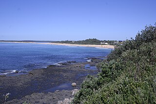
Culburra Beach, commonly referred to as Culburra, is a town located in the South Coast region of New South Wales, Australia. Located within the Shoalhaven local government area, the town is 18 kilometres (11 mi) east-southeast of Nowra on Jerrinja Wandi Wandian Aboriginal Country. At the 2016 census, the town had a population of 2,874 and is the regional centre for the coastal villages of Currarong, Callala Beach, Callala Bay and Orient Point.
Jerrabomberra is a suburb of Queanbeyan in south eastern New South Wales, Australia. Jerrabomberra consists of three sections, The Park, The Heights, and Lakeview. The Park and the Heights are divided by Edwin Land Parkway. At the 2021 census, it had 9,601 people, up from 9,508 in 2016, 9,420 in 2011, and 8,747 in 2006. Jerrabomberra is derived from the local Aboriginal place name meaning "boy frightened by storm".

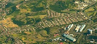
Berkeley Vale is a suburb of the Central Coast region of New South Wales, Australia. Berkeley Vale is commuting distance from Sydney. It is part of the Central Coast Council local government area and part of the federal division of Dobell.
Adamstown is a suburb of Newcastle, New South Wales, Australia, located 6 kilometres (4 mi) from Newcastle's central business district. It is split between the City of Newcastle and City of Lake Macquarie local government areas.

Chittaway Bay is a suburb of the Central Coast region of New South Wales, Australia. It is part of the Central Coast Council local government area.

Killarney Vale is a suburb of the Central Coast region of New South Wales, Australia, located approximately 5 kilometres south of The Entrance. It is part of the Central Coast Council local government area.

Lake Munmorah is a suburb of the Central Coast region of New South Wales, Australia. It is part of the Central Coast Council local government area.

Karuah is a locality in both the Port Stephens and Mid-Coast Councils, the Port Stephens lga side is part the Hunter Region while the Mid-Coast lga is in the Mid North Coast region of New South Wales, Australia. It is thought that the name means 'native plum tree' in the local Aboriginal dialect.
Cringila is a southern suburb of the city of Wollongong, New South Wales, Australia. The suburb is bounded by Berkeley, Unanderra, Lake Heights and Warrawong.
Blue Haven is a suburb on the Central Coast of New South Wales, Australia, located on Pacific Highway at Wallarah Creek. Its local government area is Central Coast Council.

Buderim is the central suburb of the town of Buderim in the Sunshine Coast Region, Queensland, Australia. In the 2016 census, the suburb of Buderim had a population of 29,355 people.

