
Montgomery County, locally also referred to as Montco, is the third-most populous county in the U.S. state of the Commonwealth of Pennsylvania, and the 71st most populous in the United States. As of 2017, the census-estimated population of the county was 826,075, representing a 3.3% increase from the 799,884 residents enumerated in the 2010 census. Montgomery County is located adjacent to and northwest of Philadelphia. The county seat is Norristown. Montgomery County is geographically diverse, ranging from farms and open land in the extreme north of the county to densely populated suburban neighborhoods in the southern and central portions of the county.

Lower Milford Township is a township in Lehigh County, Pennsylvania, in the United States. It is a suburb of Allentown, Pennsylvania, in the Lehigh Valley region of the state. Lower Milford Township is included within the New York Metropolitan Area.

Upper Milford Township is a township in Lehigh County, Pennsylvania, in the United States. It is a suburb of Allentown, Pennsylvania, in the Lehigh Valley region of the state.
Hatfield Township is a township in Montgomery County, Pennsylvania, United States. The population was 17,249 at the 2010 census. It is part of the North Penn Valley region that is centered around the borough of Lansdale.

Lower Gwynedd Township is a township in Montgomery County, Pennsylvania, United States. The population was 11,405 at the 2010 census. The township comprises four villages: Gwynedd, Gwynedd Valley, Penllyn, and Spring House.

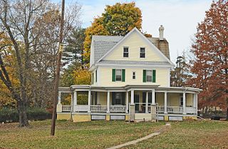
Lower Providence Township is a township in Montgomery County, Pennsylvania, United States, about 17 miles northwest of Philadelphia. The population was 25,436 at the 2010 census.

Montgomery Township is a township in Montgomery County, Pennsylvania, United States. It is the location of the Montgomery Mall, a regional shopping mall serving the Route 309 corridor of the Philadelphia suburbs. Much of Montgomery Township's development is suburban in character, with newer tract houses and strip shopping centers. Homes in Montgomery Township have North Wales and Lansdale addresses, but businesses that are located within the township boundaries are given the Montgomeryville ZIP code. The township is in the North Penn School District and is part of the North Penn Valley region that is centered around the borough of Lansdale.

Upper Dublin Township is a township in Montgomery County, Pennsylvania, United States. The population was 25,569 at the 2010 census. Until the 1950s, Upper Dublin was mostly farmland and open space, but transitioned to a residential suburb during the postwar population boom. The population went from just over 6,000 residents in the 1950s to just under 20,000 by 1970. Today, Upper Dublin is mostly spread-out development housing, and has the fourth highest median income in Montgomery County.

Upper Gwynedd Township is a township in Montgomery County, Pennsylvania, United States. The population was 15,552 at the 2010 census. North Wales Borough is surrounded by Upper Gwynedd Township on all sides, and many homes and businesses with North Wales addresses are actually in Upper Gwynedd. Many properties with Lansdale addresses are in Upper Gwynedd as well. It is part of the North Penn Valley region that is centered around the borough of Lansdale.

Upper Moreland Township is a township in Montgomery County, Pennsylvania, United States. The population was 24,015 at the 2010 census. Upper Moreland Township is primarily a residential community with distinctive neighborhoods that are complemented by several thriving business, industrial, and commercial districts. The school started in 2001
The North Penn Valley is a region of Philadelphia suburbs and exurbs in Montgomery County, Pennsylvania. It is somewhat congruent with the North Penn School District. It contains the boroughs of North Wales, Lansdale, and Hatfield, as well as the surrounding townships. The area to its west has traditionally been more rural, while the suburbs to its south and east are on the whole more affluent and densely populated.

Pennsylvania Route 63 is a 37.4-mile-long (60.2 km) state highway located in the Philadelphia, Pennsylvania area. The western terminus of the route is at PA 29 in Green Lane, Montgomery County. The eastern terminus is at Interstate 95 (I-95) in Bensalem Township, Bucks County. The route heads through a mix of suburban and rural areas of northern Montgomery County as a two-lane road, passing through Harleysville, before coming to an interchange with I-476 in Towamencin Township. From this point, PA 63 continues through predominantly suburban areas of eastern Montgomery County as a two- to four-lane road, passing through Lansdale, Maple Glen, Willow Grove, and Huntingdon Valley. Upon entering Northeast Philadelphia, the route follows Red Lion Road and U.S. Route 1 before heading southeast on a freeway called Woodhaven Road to I-95.

The 61st Pennsylvania House of Representatives District is in Southeastern Pennsylvania is represented by Liz Hanbidge. Kate M. Harper represented the 61st district for 18 years until she was defeated by Hanbidge on November 6, 2018.
James Buchanan Holland was a United States District Judge of the United States District Court for the Eastern District of Pennsylvania.
The 151st Pennsylvania House of Representatives District is located in Montgomery County and includes the following areas:

The Power Line Trail is a multi-use trail located in Horsham Township, Montgomery County, Pennsylvania. The trail follows a PECO Energy right-of-way through the township. The trail consists of six segments for a total of 5.24 miles (8.43 km).
This is list of locations in the United States named after places in Wales. A number of places in the U.S have been named after places in Wales by Welsh settlers and explorers. and are mainly in the 13 eastern states which used to be the Thirteen Colonies in the British Empire. A number of US towns such as Newport and Newtown maybe named after the similarly names Welsh towns or may have been named solely because of their location. Only those places where there is an evidential link with Wales are included here.


