
Ibestad is a municipality in Troms county, Norway. It is part of the traditional region of Central Hålogaland. The administrative centre of the municipality is the village of Hamnvik. Some of the other larger villages in Ibestad include Engenes, Laupstad, Rollnes, Sørrollnes, Sørvika, and Å.

Borkenes is the administrative centre of Kvæfjord Municipality in Troms county, Norway. The farming village is located on the island of Hinnøya, about 18 kilometres (11 mi) west of the city of Harstad. It is located along the Kvæfjorden, looking across the fjord at the island of Kvæøya.

is a town in the municipality of Ulstein, Møre og Romsdal, Norway. The town is the commercial and administrative centre of Ulstein and as such, Ulsteinvik contains 74% of the municipality's population. The 3.85-square-kilometre (950-acre) town has a population (2018) of 5,788 and a population density of 1,503 inhabitants per square kilometre (3,890/sq mi).

Korgen is the administrative centre of Hemnes Municipality in Nordland county, Norway. The village located along the river Røssåga, about 8 kilometres (5.0 mi) south of the village of Bjerka. Korgen is connected by the European route E6 highway to the nearby towns of Mo i Rana and Mosjøen. The eastern end of the Korgfjell Tunnel is located in Korgen. The village of Bleikvassli lies about 20 kilometres (12 mi) to the south along the Norwegian County Road 806. The 0.9-square-kilometre (220-acre) village has a population (2017) of 878 which gives the village a population density of 976 inhabitants per square kilometre (2,530/sq mi). This makes it the largest urban area in the municipality.
Moen is the administrative centre of Målselv Municipality in Troms county, Norway. The village of Moen is located in the Målselvdalen valley about 10 km (6.2 mi) north of the village of Andselv and Bardufoss Airport. The 0.89-square-kilometre (220-acre) village has a population (2017) of 847 which gives the village a population density of 952 inhabitants per square kilometre (2,470/sq mi).

Evenskjer is the administrative centre of Tjeldsund Municipality in Troms county, Norway. The village is located along the Tjeldsundet strait about 25 km (16 mi) south of the town of Harstad. European route E10 passes just to the north of the village of Evenskjer. The 0.81-square-kilometre (200-acre) village has a population (2017) of 785 which gives the village a population density of 969 inhabitants per square kilometre (2,510/sq mi).

Setermoen is the administrative centre of Bardu Municipality in Troms county, Norway. The village is located along the Barduelva river, about 25 kilometres (16 mi) east of the village of Sjøvegan and about 25 kilometres (16 mi) south of Bardufoss.

Sjøvegan is the administrative centre of Salangen Municipality in Troms county, Norway. The village is located at the end of the Sagfjorden, a branch of the Salangen fjord. The river Salangselva empties into the fjord at Sjøvegan. The river flows through the lakes Nervatnet and Øvrevatnet just to the east of the village.

Heggelia is a village in Målselv Municipality in Troms county, Norway. The village is located along the river Barduelva and it is part of the commercial centre of Bardufoss. Heggelia is sits along the European route E6 highway about 2.5 km (1.6 mi) south of Andselv and Bardufoss Airport.
Astafjord is a former municipality in Troms county, Norway. The 310-square-kilometre (120 sq mi) municipality existed from 1926 until its dissolution in 1964. It was located in the eastern part of the present-day municipality of Tjeldsund. The municipality surrounded the Grovfjorden. The administrative center of the former municipality was the village of Grov where Astafjord Church is located. The Astafjorden (strait) flowed along the northern part of the municipality and it was the namesake for the municipality.

Birkeland is the administrative centre of the municipality of Birkenes in Agder county, Norway. The village is located on the eastern shore of the river Tovdalselva, across the river from the village of Flakk. The Norwegian National Road 41 runs through the village. The village is located about 30 kilometres (19 mi) northeast of the city of Kristiansand and about 14 kilometres (8.7 mi) northwest of the town of Lillesand.

Å is a village in Lavangen Municipality in Troms og Finnmark county, Norway. The village is located along the northern shore of the Lavangen fjord, about 4 kilometres (2.5 mi) north of the administrative centre of Tennevoll and about 52 kilometres (32 mi) east of the town of Harstad.
Andørja is a former municipality in Troms county in Norway. The 135-square-kilometre (52 sq mi) municipality existed from 1926 until its dissolution in 1964. It was located in the northeastern half of the present-day Ibestad Municipality. It encompassed the entire island of Andørja plus a number of other small islands and skerries surrounding it. The administrative centre was located at Engenes where the Andørja Church was also located.

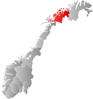
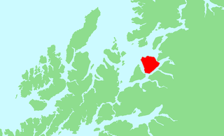
Rolla (Norwegian) or Rálli (Northern Sami) is an island in Ibestad Municipality in Troms county, Norway. The island of Andørja lies to the northeast, the Vågsfjorden lies to the north and west, and the Astafjorden lies to the south. The highest point on the 106-square-kilometre (41 sq mi) island of Rolla is Drangen at a height of 1,022 metres (3,353 ft). The population on Rolla (2001) is 1,078.

Sylte or Valldal is a village in Fjord Municipality in Møre og Romsdal county, Norway. The village is situated at the southern end of the Valldalen valley along the shore of the Norddalsfjorden near the mouth of the Valldøla river, just west of the entrance to the Tafjorden. The 0.71-square-kilometre (180-acre) village has a population (2012) of 411. This gives the village a population density of 579 inhabitants per square kilometre (1,500/sq mi).
Andørja (Norwegian) or Áttir (Northern Sami) is an island in Ibestad Municipality in Troms county, Norway. The 135-square-kilometre (52 sq mi) island lies about 25 kilometres (16 mi) east of the town of Harstad. The island is located entirely within the present-day municipality of Ibestad, although the island itself was a separate municipality (Andørja) from 1926 until 1964. The largest population area on Andørja island is the Å - Ånstad - Laupstad area on the west coast with 205 residents (2001). Andørja Church is located in Engenes on the northwestern tip of the island.
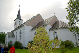
Ibestad Church is a parish church of the Church of Norway in Ibestad Municipality in Troms county, Norway. It is located in the village of Hamnvik in eastern part of the island of Rolla. It is the main church for the Ibestad parish which is part of the Trondenes prosti (deanery) in the Diocese of Nord-Hålogaland. The white, stone, neo-gothic church was built in a long church style in 1881 using plans drawn up by the architect J.A. Johansen from Trondheim. The church seats about 500 people.

Engenes is a small fishing village in Ibestad Municipality in Troms county, Norway. It is located on the northwestern tip of the island of Andørja. The village is home to Andørja Church, the main church for the island.
Lillesand is the administrative centre of Lillesand municipality in Agder county, Norway. The town is located along the Skagerak coast, about 18 kilometres (11 mi) southwest of the town of Grimstad and about 25 kilometres (16 mi) northeast of the city of Kristiansand. The 5.08-square-kilometre (1,260-acre) town has a population (2019) of 7,966 and a population density of 1,567 inhabitants per square kilometre (4,060/sq mi). In Norway, Lillesand is considered a by which can be translated as either a "town" or "city" in English.

Vennesla is the administrative centre of Vennesla municipality in Agder county, Norway. The village is located in the upper Torridal valley along the river Otra, about 15 kilometres (9.3 mi) north of the city of Kristiansand. The village itself extends for about 10 kilometres (6.2 mi) along both sides of the river. The Norwegian National Road 9 passes through Mosby, about 6 kilometres (3.7 mi) south of Vennesla. The Sørlandsbanen railway line passes through Vennesla, stopping at Vennesla Station. The lake Venneslafjorden is located on the river Otra in the northern part of the village of Vennesla.


