St. Tammany Parish is a parish located in the U.S. state of Louisiana named after Tamanend, the legendary Lenape Chief of Chiefs and the "Patron Saint of America." At the 2020 census, the population was 264,570, making it the fourth-most populous parish in Louisiana. The parish seat is Covington. The parish was founded in 1810.
St. Bernard Parish is a parish in the U.S. state of Louisiana. The parish seat and largest community is Chalmette. The parish was formed in 1807. St. Bernard Parish is part of the New Orleans–Metairie metropolitan statistical area; the parish is located southeast of the city of New Orleans and comprises the Chandeleur Islands and Chandeleur Sound in the east.
Plaquemines Parish is a parish located in the U.S. state of Louisiana. With a population of 23,515 at the 2020 census, the parish seat is Pointe à la Hache and the largest community is Belle Chasse. The parish was formed in 1807.
Bay St. Louis is a city in and the county seat of Hancock County, Mississippi, in the United States. Located on the Gulf Coast on the west side of the Bay of St. Louis, it is part of the Gulfport–Biloxi Metropolitan Statistical Area. The population was 9,284 at the 2020 census, up from 9,260 at the 2010 census.

Diamondhead is a city in southeastern Hancock County, Mississippi, United States. The city is located just over 50 miles (80 km) northeast of New Orleans, Louisiana. It is part of the Gulfport−Biloxi Metropolitan Statistical Area. In February 2012, Diamondhead was officially incorporated as a city. In the 2020 USA decennial census, the city population was 9,529.

Kiln is an unincorporated community and census-designated place (CDP) in Hancock County, Mississippi, United States. The town is located about 50 miles (80 km) northeast of New Orleans, Louisiana. It is part of the Gulfport-Biloxi Metropolitan Statistical Area. The population was 2,238 at the 2010 census.

Pearlington is a census-designated place (CDP) in Hancock County, Mississippi, United States, on U.S. Route 90, along the Pearl River, at the Louisiana state line. It is part of the Gulfport–Biloxi, Mississippi Metropolitan Statistical Area. The population was 1,684 at the 2000 census. On August 29, 2005, Hurricane Katrina made landfall just south of Pearlington.

Shoreline Park is a former census-designated place (CDP) in Hancock County, Mississippi. It is part of the Gulfport–Biloxi, Mississippi Metropolitan Statistical Area. The population was 4,058 at the 2000 census. It was not included in the 2010 census. The area is now largely within the city limits of Bay St. Louis, although some of the western side of the former CDP is still unincorporated after Hurricane Katrina in 2005.

Waveland is a city located in Hancock County, Mississippi, United States, on the Gulf of Mexico. It is part of the Gulfport–Biloxi, Mississippi Metropolitan Statistical Area. The city of Waveland was incorporated in 1972. As of the 2010 census, the city had a population of 6,435. Waveland was nearly destroyed by Hurricane Camille on August 17, 1969, and by Hurricane Katrina on August 29, 2005.

Biloxi is a city in Harrison County, Mississippi, United States. It lies on the Gulf Coast in southern Mississippi, bordering the city of Gulfport to its west. The adjacent cities are both designated as seats of Harrison County. The population of Biloxi was 49,449 at the 2020 census, making it the state's 4th most populous city. It is a principal city of the Gulfport–Biloxi metropolitan area, home to 416,259 residents in 2020. The area's first European settlers were French colonists.

Pass Christian, nicknamed The Pass, is a city in Harrison County, Mississippi, United States. It is part of the Gulfport–Biloxi Metropolitan Statistical Area. The population was 6,307 at the 2019 census.
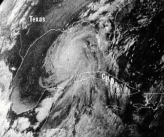
Hurricane Camille was a powerful, deadly and destructive Category 5 major hurricane which became the second most intense tropical cyclone on record to strike the United States and is one of just four Category 5 hurricanes to make landfall in the U.S.

Hurricane Katrina was a devastating and deadly Category 5 Atlantic hurricane that caused 1,836 fatalities and damages estimated between $97.4 billion to $145.5 billion in late August 2005, particularly in the city of New Orleans and its surrounding area. At the time, it was the costliest tropical cyclone on record, later tied by Hurricane Harvey in 2017. Katrina was the twelfth tropical cyclone, the fifth hurricane, and the third major hurricane of the 2005 Atlantic hurricane season. It was also the fourth-most intense Atlantic hurricane to make landfall in the contiguous United States, gauged by barometric pressure.
The article covers the Hurricane Katrina effects by region, within the United States and Canada. The effects of Hurricane Katrina, in late August 2005, were catastrophic and widespread. It was one of the deadliest natural disasters in U.S. history, leaving at least 1,836 people dead, and a further 135 missing. The storm was large and had an effect on several different areas of North America.
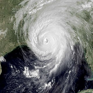
Hurricane Katrina's winds and storm surge reached the Mississippi coastline on the morning of August 29, 2005. beginning a two-day path of destruction through central Mississippi; by 10 a.m. CDT on August 29, 2005, the eye of Katrina began traveling up the entire state, only slowing from hurricane-force winds at Meridian near 7 p.m. and entering Tennessee as a tropical storm. Many coastal towns of Mississippi had already been obliterated, in a single night. Hurricane-force winds reached coastal Mississippi by 2 a.m. and lasted over 17 hours, spawning 11 tornadoes and a 28-foot (8.5 m) storm surge flooding 6–12 miles (9.7–19.3 km) inland. Many, unable to evacuate, survived by climbing to attics or rooftops, or swimming to higher buildings and trees. The worst property damage from Katrina occurred in coastal Mississippi, where all towns flooded over 90% in hours, and waves destroyed many historic buildings, with others gutted to the 3rd story. Afterward, 238 people died in Mississippi, and all counties in Mississippi were declared disaster areas, 49 for full federal assistance. Regulations were changed later for emergency centers and casinos. The emergency command centers were moved higher because all 3 coastal centers flooded at 30 ft (9.1 m) above sea level. Casinos were allowed on land rather than limited to floating casino barges as in 2005.

The Mississippi Gulf Coast, also known as Mississippi Coast, Mississippi Gulf Coast region, Coastal Mississippi, and The Coast, is the area of Mississippi along the Mississippi Sound at the northern extreme of the Gulf of Mexico.
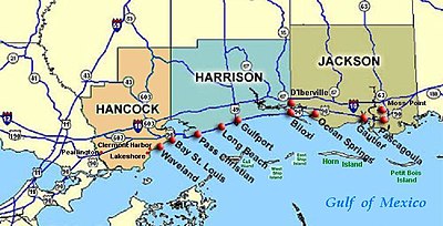
The Gulfport-Biloxi Metropolitan Statistical Area is a metropolitan statistical area (MSA) in the Mississippi Gulf Coast region that includes four counties – Hancock, Harrison, Jackson and Stone. The principal cities are Gulfport and Biloxi. The 2010 census placed the Gulfport-Biloxi MSA population at 388,488, though as of 2019, it was estimated to have increased to 417,665. The area was significantly impacted by Hurricane Katrina on August 29, 2005, and prior to the hurricane, had experienced steady to moderate population growth. However, growth has since rebounded, with the population steadily increasing every year throughout the 2010s.

The Gulfport–Biloxi–Pascagoula Combined Statistical Area is made up of five counties in the Mississippi Gulf Coast region. The statistical area consists of the Gulfport–Biloxi Metropolitan Statistical Area and the Pascagoula Metropolitan Statistical Area. The 2010 census placed the CSA population at 411,066, and as of 2019, is estimated to be 442,165. The area was significantly impacted by Hurricane Katrina on August 29, 2005, although population growth has steadily rebounded in recent years.
The Hancock County School District is a public school district based in the community of Kiln, Mississippi (USA).
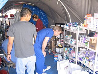
The New Waveland Café and New Waveland Clinic together formed a disaster response center consisting of a combination café, soup kitchen, medical clinic, donation center, and market, that operated free of charge from September 5 to December 1, 2005 in immediate Post-Katrina Mississippi Gulf Coast in Waveland, Hancock County, Mississippi. The cafe and clinic were founded in response to Hurricane Katrina and provided free food and free medical care to hurricane victims for three months. They were located in tents in the parking lot of Fred's Department Store at 790 Hwy 90 in Waveland, across the street from the destroyed and gutted Waveland Police Department. The New Waveland Cafe served three free meals every day to thousands of residents and volunteers. The New Waveland Clinic provided free health care to over 5,500 patient contacts. As well, a group of hippies and Christians came together to form a unique group which worked together to provide emergency relief.