
Yavapai County is near the center of the U.S. state of Arizona. As of the 2020 census, its population was 236,209, making it the fourth-most populous county in Arizona. The county seat is Prescott.

Lake Mead National Recreation Area is a U.S. national recreation area in southeastern Nevada and northwestern Arizona. Operated by the National Park Service, Lake Mead NRA follows the Colorado River corridor from the westernmost boundary of Grand Canyon National Park to just north of the cities of Laughlin, Nevada and Bullhead City, Arizona. It includes all of the eponymous Lake Mead as well as the smaller Lake Mohave – reservoirs on the river created by Hoover Dam and Davis Dam, respectively – and the surrounding desert terrain and wilderness.
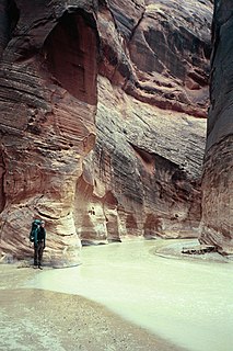
The Paria River is a tributary of the Colorado River, approximately 95 miles (153 km) long, in southern Utah and northern Arizona in the United States. It drains a rugged and arid region northwest of the Colorado, flowing through roadless slot canyons along part of its course.

The Paria Canyon-Vermilion Cliffs Wilderness is a 112,500 acres (455 km2) wilderness area located in northern Arizona and southern Utah, United States, within the arid Colorado Plateau region. The wilderness is composed of broad plateaus, tall escarpments, and deep canyons.

The Beaver Dam Mountains Wilderness is a wilderness area located in northwestern Arizona and southwestern Utah, USA, within the arid Colorado Plateau region. The jagged mountains and gently sloping alluvial plain of the Beaver Dam Mountains straddle the border between the two states. The Wilderness contains some of the lowest elevation land in Utah, and includes a 13 miles (21 km) section of the Virgin River Gorge. The area comprises some 18,667 acres (7,554 ha), 15,000 acres (6,100 ha) of which in Arizona and approximately 3,667 acres (1,484 ha) in Utah. The area was designated Wilderness by the U.S. Congress in 1984 and is administered by the Bureau of Land Management.

The Mount Trumbull Wilderness is a 7,880 acre (31 km2) wilderness area located on the Uinkaret Plateau in the Arizona Strip. It is managed by the Bureau of Land Management.
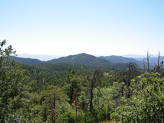
The Bradshaw Mountains are a mountain range in central Arizona, United States, named for brothers Isaac and William D. Bradshaw after their deaths, having been formerly known in English as the Silver Mountain Range.

The Mazatzal Mountains are a mountain range in south central Arizona, about 30–45 miles northeast of Phoenix and the Phoenix metropolitan area. The origin of the name remains obscure but one possibility is that it is from the Nahuatl language meaning "place of the deer". The crest of the Mazatzals forms the county line between Maricopa County and Gila County. SR 87, the Beeline Highway, traverses the Mazatzals on its way to Payson. The highest peak is Mazatzal Peak at 7,903 feet (2,409 m). They also include the Four Peaks, with elevation 7,659 ft, 2,334 m; a prominent mountain and landmark of the eastern Phoenix area.
Needle's Eye Wilderness is an 8,760-acre (35.5 km2) wilderness area located approximately 20 miles (32 km) southeast of the town of Globe in Gila County in the U.S. state of Arizona.

Salt River Canyon Wilderness is a 32,101 acres (12,991 ha) wilderness area located within the Tonto National Forest in the U.S. state of Arizona.

The Hassayampa River is an intermittent river, the headwaters of which are just south of Prescott, Arizona, and flows mostly south towards Wickenburg, entering the Gila River near Hassayampa. Although the river has only subsurface flow for much of the year, it has significant perennial flows above ground within the Hassayampa River Canyon Wilderness and the Nature Conservancy's Hassayampa River Preserve, near Wickenburg. The river is about 113 miles (182 km) long, with a watershed of 1,410 square miles (3,700 km2), most of it desert.

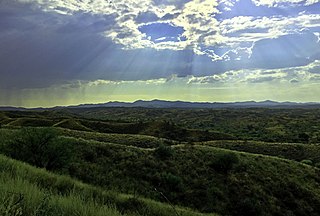
The Hieroglyphic Mountains are a mountain range located in central Arizona. The Hieroglyphics roughly straddle the border between Maricopa and Yavapai counties and form an effective physical barrier northwest of the Phoenix Metropolitan Area. Due to their proximity to Phoenix and its environs, the mountains offer a number of outdoor recreational activities.
The Pajarito Mountains is a small mountain range of western Santa Cruz County, Arizona, United States, that extend south into Sonora, Mexico. The range is adjacent the Atascosa Mountains at its north, with both ranges in the center of a north-south sequence of ranges called the Tumacacori Highlands. The Highlands have the Tumacacori Mountains at the north, and south of the U.S.-Mexico border, the Sierra La Esmeralda range. The Tumacacori Highlands are part of a regional conservancy study of "travel corridors" for cats, called Cuatro Gatos, Four Cats, for mountain lions, ocelot, bobcat, and jaguar.

The Buckskin Mountains is a mountain range in La Paz County, Arizona, United States. The range lies just east of the north–south Colorado River, and borders south of the east–west, west-flowing Bill Williams River.

Aravaipa Creek is a drainage between three mountain ranges in southwest Graham County, Arizona – the Galiuro Mountains, the Santa Teresa Mountains and the Pinaleno Mountains. These mountains are part of the high altitude Madrean Sky Islands located in southern Arizona and New Mexico in the United States, and northern Sonora and Chihuahua states in Mexico.

The Tonopah Desert is a small desert plains region of the Sonoran Desert, located west of Phoenix, Arizona. It is adjacent north of Interstate 10 and lies at the southwest intersection of the Hassayampa River with the Gila River. The Tonopah Desert is also just north of the Gila Bend Mountains massif which create the Gila Bend of the river.

The Vulture Mountains is a 29-mile (47 km) long, arid, low-elevation mountain range located in northwest Maricopa County, Arizona, United States. It is in the north perimeter region of the Sonoran Desert. The Arizona transition zone mountain ranges lie north and northeast, just north of Wickenburg, Arizona. The Yarnell Hill, about 14 miles (23 km) north of Wickenburg, rising into the Weaver Mountains to Yarnell, marks the dramatic elevation rise from the desert. It is also a viewpoint southwest and southeast of the desert regions, including the Vulture Mountains.

The Grand Wash Cliffs extend south-southeast from the Grand Canyon-Parashant National Monument in northwest Arizona west of the Shivwits Plateau south through the Grand Cliffs Wilderness and into the Lake Mead Recreation Area. The Grand Wash Cliffs cross the Grand Canyon where the Colorado River enters Lake Mead. To the south of the Grand Canyon the Grand Wash Cliffs continue past the east side of Grapevine Mesa and then southeast above and east of the Hualapai Valley forming the southwest margin of the Music Mountains.
