Related Research Articles

Spain is a country located in southwestern Europe occupying most of the Iberian Peninsula. It also includes a small exclave inside France called Llívia, as well as the Balearic Islands in the Mediterranean, the Canary Islands in the Atlantic Ocean 108 km (67 mi) off northwest Africa, and five places of sovereignty on and off the coast of North Africa: Ceuta, Melilla, Islas Chafarinas, Peñón de Alhucemas, and Peñón de Vélez de la Gomera.

Extremadura is an autonomous community of Spain. Its capital city is Mérida. Located in the central-western part of the Iberian Peninsula, it is made up of the two largest provinces of Spain: Cáceres and Badajoz. Extremadura is bordered by Portugal to the west and by the autonomous communities of Castile and León (north), Castilla–La Mancha (east) and Andalusia (south). Its official language is Spanish.

Castile and León is an autonomous community in north-western Spain.

Castilla–La Mancha, or Castile La Mancha, is an autonomous community of Spain. Comprising the provinces of Albacete, Ciudad Real, Cuenca, Guadalajara and Toledo, it was created in 1982. It is bordered by Castile and León, Madrid, Aragon, Valencia, Murcia, Andalusia, and Extremadura. It is one of the most sparsely populated of Spain's regions. Albacete is the largest and most populous city. The government headquarters are in Toledo and the High Court headquarters are in Albacete.

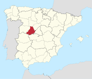
Guadalajara is a province of central/north-central Spain, in the northern part of the autonomous community of Castilla–La Mancha. As of 2013 it had a population of 257,723 people. The population of the province has grown in the last 10 years.
Ávila is a province of central-western Spain, in the southern part of the autonomous community of Castile and León. It is bordered on the south by the provinces of Toledo and Cáceres, on the west by Salamanca, on the north by Valladolid, and on the east by Segovia and Madrid. Ávila has a population of 158,265 (2018) and is ranked 47th out of 50 of Spanish provinces in population. Its capital is Ávila.
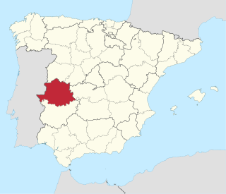
The province of Cáceres is a province of western Spain, and makes up the northern half of the autonomous community of Extremadura. Its capital is the city of Cáceres. Other cities in the province include Plasencia, Coria, Navalmoral de la Mata and Trujillo, the birthplace of Francisco Pizarro González. As of 2014, the province had 408,703 inhabitants, of whom a quarter lived in the capital. The Tagus river runs through the province.

Sierra de Gata is one of the main mountain ranges in the Sistema Central, Spain. The highest point is Peña Canchera.
Haya may refer to:

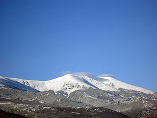
The Sierra de Gredos is a mountain range in central Spain that spans the provinces of Ávila, Salamanca, Cáceres, Madrid, and Toledo. It is part of the much larger Sistema Central of mountain ranges. Its highest point is Pico Almanzor, at 2,592 metres and it has been declared a natural park by the Autonomous Community of Castile and León. The Sierra de Gredos is one of the most extensive mountain ranges of the Central System; it comprises five river valleys: the Alto Tormes, the Alto Alberche, the Tiétar Oriental, the Tiétar Occidental y la Vera, and the Valle del Ambroz. The first known inhabitants were the Vettones, a pre-Roman Celtic people. The central part of the range encomprises the Sierra de Gredos Regional Park.

The Sierra de Guadarrama is a mountain range forming the main eastern section of the Sistema Central, the system of mountain ranges along the centre of the Iberian Peninsula. It is located between the systems Sierra de Gredos in the province of Ávila, and Sierra de Ayllón in the province of Guadalajara.

The woodlands of the Iberian Peninsula are distinct ecosystems on the Iberian Peninsula. Although the various regions are each characterized by distinct vegetation, the borders between these regions are not clearly defined, and there are some similarities across the peninsula.
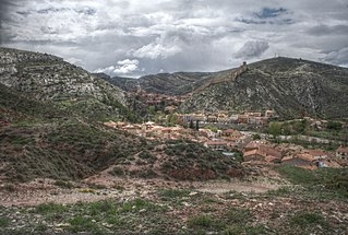
Villanueva de la Sierra is a municipality located in the province of Cáceres, Extremadura, Spain. According to the 2005 census (INE), the municipality has a population of 577 inhabitants.
The Iberian System, is one of the major systems of mountain ranges in Spain. It consists of a vast and complex area of mostly relatively high and rugged mountain chains and massifs located in the central region of the Iberian Peninsula, but reaching almost the Mediterranean coast in the Valencian Community in the east.

The Maestrazgo or Maestrat is a natural and historical mountainous region, located at the eastern end of the Sistema Ibérico mountain range, in Spain. It encompasses the north of the Autonomous Community of Valencia, in Castellón province, and parts of the east of the Aragonese province of Teruel. The area is mountainous and sparsely populated with a rich mixture of flora and fauna.

Gata is a municipality located in the province of Cáceres, Extremadura, Spain. The Postal Code is 10860.
Moraleja is a municipality located in the province of Cáceres, Extremadura, Spain. It is the most important town in the Sierra de Gata comarca. The Postal Code is 10128.
Sierra de Albarracín Comarca is a comarca in the Province of Teruel, Aragon region, northeastern Spain. It is located in mountain ranges of the Sistema Ibérico.
The climate in Spain varies across continental Spain. Spain is the most climatically diverse country in Europe with 13 different Köppen climates, excluding the Canary Islands, and is within the 10 most climatically diverse countries in the world. Five main climatic zones can be distinguished, according to the country's Köppen-Geiger climate classification and orographic conditions:

The Sierra de Francia is a comarca located at the southern end of Salamanca Province, Castile and León, Spain. It is located about 70 km from Salamanca city. It borders with the Las Hurdes and Las Batuecas comarcas of Extremadura to the south; the Campo Charro to the north and the Sierra de Béjar to the east. The region is sparsely inhabited and its few towns have great cultural value.
References
- Guía de Árboles y Arbustos de Castilla y León (Oria de Rueda, Diez)
Coordinates: 40°27′04.7″N6°04′45.1″W / 40.451306°N 6.079194°W