Related Research Articles
The Upper Similkameen Indian Band or Upper Smelqmix, is a First Nations band government in the Canadian province of British Columbia, whose head offices are located in town of Hedley in the Similkameen Country. They are a member of the Okanagan Nation Alliance.

The Gwa'Sala-Nakwaxda'xw Nations are a union of two Kwakwaka'wakw peoples in a band government based on northern Vancouver Island in British Columbia, Canada, whose main reserve community is near the town of Port Hardy in the Queen Charlotte Strait region of the Central Coast region of British Columbia, Canada. The band government is a member of the Kwakiutl District Council and, for treaty negotiation purposes, the Winalagalis Treaty Group which includes three other members of the Kwakiutl District Council.
Ḵwiḵwa̱sut'inux̱w Ha̱xwa'mis, formerly the Kwicksutaineuk-ah-kwa-mish First Nation is a First Nations band government based on northern Vancouver Island in British Columbia, Canada, in the Queen Charlotte Strait region. It is a member of the Musgamagw Tsawataineuk Tribal Council, along with the ‘Namgis First Nation and the Tsawataineuk First Nation. The Kwikwasut'inuxw and Haxwa'mis are two of the many subgroups of the peoples known as Kwakwaka'wakw, which has two meanings: "smoke of the world" or "beach at the north side of the river."

The Stswecem'c Xgat'tem First Nation, formerly known as Canoe Creek Band/Dog Creek Indian Band, created as a result of merger of the Canoe Creek Band and Dog Creek Band is a First Nations government of the Secwepemc (Shuswap) Nation, located in the Fraser Canyon-Cariboo region of the Central Interior of the Canadian province of British Columbia. It was created when the government of the then-Colony of British Columbia established an Indian reserve system in the 1860s. It is a member government of the Northern Shuswap Tribal Council.
The Lytton First Nation, a First Nations band government, has its headquarters at Lytton in the Fraser Canyon region of the Canadian province of British Columbia. While it is the largest of all Nlaka'pamux bands, unlike all other governments of the Nlaka'pamux (Thompson) people, it is not a member of any of the three Nlaka'pamux tribal councils, which are the Nicola Tribal Association, the Fraser Canyon Indian Administration and the Nlaka'pamux Nation Tribal Council.
The Hartley Bay Indian Band is also known as the Gitga'at First Nation or the Hartley Bay First Nation. The members of the Gitga'at First nation are often referred to as Gitka'a'ata. The population of Gitk’a’ata peoples living in Hartley Bay ranges from approximately 130-200 people. There are also about 400-500 Gitk’a’ata peoples living in Prince Rupert, British Columbia, Canada, a neighboring territory. The Gitk’a’ata people have lived in Hartley Bay for hundreds of years, if not always. Some notable things regarding the Gitga'at First Nation are their economy, geography, government, sports involvement, COVID-19 regulations, and relations.
Yale First Nation is a First Nations government located at Yale, British Columbia. Yale has 16 distinct reserves stretching from near Sawmill Creek to American Creek, with the most southern reserve situated at Ruby Creek in the District of Kent.
The Tlowitsis Nation, formerly the Klowitsis Tribe, the Turnour Island Band and the Tlowitsis-Mumtagila First Nation, is the Indian Act band government of the Ławit'sis (Tlowitsis) tribe of the Kwakwaka'wakw peoples, located in the Queen Charlotte Strait-Johnstone Strait area in the Discovery Islands between Vancouver Island and the British Columbia mainland in Canada. Ławit'sis territory covers parts of northern Vancouver Island, Johnstone Strait, and adjoining inlets of the mainland. Kalugwis, on Turnour Island, was their principal community in times past, but the band's offices are in the city of Campbell River to the southeast. Hanatsa IR No. 6 on Port Neville is the most populated of the band's Indian reserves.
Kitselas First Nation is the band government of the Kitselas subgroup of the Tsimshian. The band government is based at Gitaus in the Skeena Valley in the Skeena River valley to the northeast of the city of Terrace, British Columbia, Canada. Though there is no Tsimshian tribal council, they are a participant in the Tsimshian First Nations treaty council.
Harbledown Island is an island in the Central Coast region of British Columbia, Canada, located west of West Cracroft Island. It is at the west end of Johnstone Strait and lies at the eastern edge of the Queen Charlotte Strait region. Hanson Island is to its west, West Cracroft Island to the south and southeast, across Baronet Passage, and Turnour Island to the northwest, across Beware Passage.

Port Neville is a bay, port and locality on the north side of Johnstone Strait, south of Call Inlet, in the Central Coast region of British Columbia, Canada.
Matilpi is a locality on the Central Coast of British Columbia, Canada, located northeast of Hull Island on the east side of Havannah Channel.
Kalugwis, or Karlukwees or Qalogwis, is the principal community of the Tlowitsis Nation of the Kwakwaka'wakw peoples of the Johnstone Strait region of the South Coast of British Columbia, Canada. It is located on the south shore of Turnour Island facing Beware Passage and is within Karlukwees Indian Reserve No. 1, a.k.a. Karlukwees 1, 10.8 ha.

Turnour Island is an island in the Johnstone Strait region of the Central Coast of British Columbia, located between Gilford Island and West Cracroft Island. On the other side Canoe Passage on its northwest is Village Island, while to its south and southwest is Beware Passage, across from which is Harbledown Island. Gilford Island is to the north across Tribune Channel. Separating Turnour from West Cracroft is Clio Channel.

East Cracroft Island is an island in the Johnstone Strait region of the Central Coast region of British Columbia, Canada. It is the smaller of the two Cracroft Islands, and at low tide is really one island with its larger neighbour, West Cracroft Island. On the south side of the shallows that form an isthmus between them at low tide is Port Harvey, a short, wide inlet or bay. On its east shore is Keecekiltum Indian Reserve No. 2, which is under the governance of the Tlowitsis Nation of the Kwakwaka'wakw peoples. at 50°33′00″N126°16′00″W.
Klaoitsis Island, also perhaps Adlagamalla in Kwak'wala, is an island in the Johnstone Strait region of the Central Coast region of British Columbia, Canada. It is located to the south of Turnour Island in Clio Channel. The name is an alternate spelling of Ławit'sis or Tlowitsis, the name of the Kwakwaka'wakw group whose territory it is in.
Klaywatse was a village of the Matilpi group of Kwakwaka'wakw, located to the west of today's Haylahte IR No. 3 in British Columbia, on an island in the mouth of the Adam River.
The Adam River is a river on northern Vancouver Island, British Columbia, Canada, flowing north into the Johnstone Strait northwest of the community of Sayward. The Adam's main tributary is the Eve River. The Kwak'wala name for the river is He-la-de, meaning "land of plenty", a reference to abundant berries, birds, game and salmon. That name is reflected in that of Haylahte Indian Reserve No. 3, which is on the east bank of the Adam's mouth. The former Matilpi village of Klaywatse was located on an island in the river's estuary.
The Quaal River is a river in the Kitimat Ranges of the Coast Mountains in British Columbia, Canada, flowing south into Kitkiata Inlet in the North Coast region.
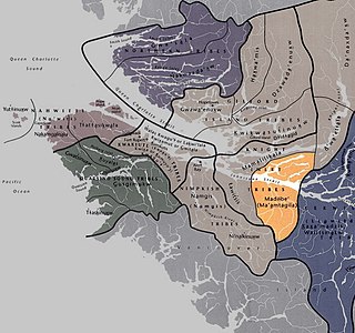
The Ma’amtagila First Nation (also styled Maamtagila), formerly known as Mahteelthpe or Matilpi, are an Indigenous nation and part of the Kwakwaka'wakw peoples. Their territory is located in the Queen Charlotte Strait-Johnstone Strait area in the Discovery Islands between Vancouver Island and the British Columbia mainland in Canada.
References
- ↑ Haylahte 3 (Indian reserve)"
- ↑ BC Names/GeoBC entry "Klaywatse"
- ↑ "SCHEDULE OF INDIAN RESERVES IN THE DOMINION OF CANADA PART 2 RESERVES IN THE PROVINCE OF BRITISH COLUMBIA RECOMPILED AND CORRECTED UP TO MARCH 31, 1943". Library and Archives Canada. Retrieved October 17, 2019.
50°28′00″N126°16′00″W / 50.46667°N 126.26667°W
| | This article about an Indian reserve in British Columbia is a stub. You can help Wikipedia by expanding it. |