This page is based on this
Wikipedia article Text is available under the
CC BY-SA 4.0 license; additional terms may apply.
Images, videos and audio are available under their respective licenses.
The Darling Scarp, also referred to as the Darling Range or Darling Ranges, is a low escarpment running north-south to the east of the Swan Coastal Plain and Perth, Western Australia. The escarpment extends generally north of Bindoon, to the south of Pemberton. The adjacent Darling Plateau goes easterly to include Mount Bakewell near York and Mount Saddleback near Boddington. It was named after the Governor of New South Wales Lieutenant-General Ralph Darling.
Ascot, Ascott or Askot may refer to:
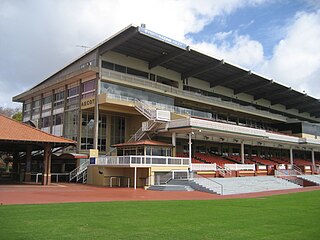
Ascot Racecourse is the major racecourse in Perth, Western Australia, situated approximately 8 kilometres east of the Perth central business district, with the headquarters of the Perth Racing positioned directly opposite.

Byford is a suburb on the south-eastern edge of Perth, Australia, and has its origins in a township that was gazetted under the name "Beenup" in 1906. "Beenup", a corruption of the Aboriginal name associated with nearby Beenyup Brook, was the spelling that had been applied to a railway siding there. The uncorrupted form, "Bienyup" received mention in surveyor Robert Austin's account of an expedition through the area in 1848. In 1920, the name of the township was changed to Byford.

Burswood is an inner southeastern suburb of Perth, Western Australia, located immediately across the Swan River from Perth's central business district (CBD). Its local government area is the Town of Victoria Park. Burswood is the location of the State Tennis Centre, Perth Stadium, Belmont Park Racecourse, and the Crown Perth casino and hotel complex.
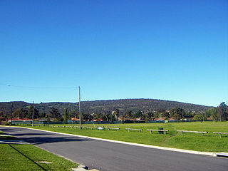
Glen Forrest is a suburb within the Shire of Mundaring, south of John Forrest National Park, west of Mahogany Creek, east of Darlington, and north of the Helena River. Its northern boundary is determined by the Great Eastern Highway.
The Mundaring Branch Railway is an historical section of the original Eastern Railway main line across the Darling Scarp in the Western Australian Government Railways system.
Midvale is a suburb of Perth, Western Australia which is split between the City of Swan and the Shire of Mundaring. Its postcode is 6056.
The Town of Midland was a local government area in the eastern suburbs of Perth, Western Australia, centred on the suburb of Midland.

The Spring Vale Cemetery railway line, in Melbourne, Australia, branched from the now Pakenham Line at Springvale railway station, for a short 1.87 km (1.16 mi) journey to the Necropolis. The terminus was a railway station of the same name.

Bellevue railway station was a junction station located on the Eastern Railway in Bellevue, Western Australia.

The Roman Catholic Archdiocese of Perth is a Latin Church metropolitan archdiocese of the Catholic Church in Australia covering the Greater Perth, Goldfields-Esperance, Peel and Wheatbelt regions of Western Australia.

Belmont Park Racecourse is one of the two major horse racing venues within the Perth, Western Australia metropolitan area, the other being Ascot Racecourse. The track has a circumference of 1,699 m (5,574 ft) with a 333 m (1,093 ft) straight. Belmont is Perth's winter racecourse, with fully enclosed facilities for spectators.

Kalamunda is an electoral district of the Legislative Assembly in the Australian state of Western Australia.

Statham's Quarry is the site of a quarry on the Darling Scarp on the southern side of the entrance of the Helena River valley on to the Swan Coastal Plain in Perth, Western Australia. It is located in Gooseberry Hill and is within the bounds of the Gooseberry Hill National Park.
The Western Australian Turf Club (WATC), later known as Perth Racing, was established in late nineteenth century as an elite social institution and administrator of the Western Australian horse racing industry. They manage two racecourses in Perth, Ascot Racecourse and Belmont Park Racecourse.
Some aspects of the clubs functions were taken over by Racing and Wagering Western Australia when it was created in 2003.
Darling Range Hotel was a hotel in Bellevue, Western Australia, on the end of the slope on the Great Eastern Highway at the 'bottom of' Greenmount Hill and just north of the former Bellevue railway station, and over the road from the Helena Vale Racecourse.