Henderson, Kentucky | |
---|---|
Coordinates: 37°50′8″N87°34′51″W / 37.83556°N 87.58083°W | |
Country | United States |
State | Kentucky |
County | Henderson |
Established | 1797 |
Incorporated | 1840 |
Named for | land speculator Richard Henderson |
Government | |
• Mayor | Brad Staton [1] |
Area | |
• Total | 18.39 sq mi (47.63 km2) |
• Land | 16.11 sq mi (41.73 km2) |
• Water | 2.28 sq mi (5.90 km2) 13.01% |
Elevation | 407 ft (124 m) |
Population (2020) | |
• Total | 27,981 |
• Estimate (2022) [3] | 27,697 |
• Density | 1,736.66/sq mi (670.51/km2) |
Time zone | UTC−6 (CST) |
• Summer (DST) | UTC−5 (CDT) |
ZIP Codes | 42420, 42419 |
Area code(s) | 270 & 364 |
FIPS code | 21-35866 |
GNIS feature ID | 0494023 |
Website | www |
Henderson is a home rule-class city [4] along the Ohio River and the county seat of Henderson County, Kentucky, United States. The population was 29,781 at the 2020 U.S. census. It is part of the Evansville Metropolitan Area, locally known as the "Tri-State Area," and is considered the southernmost suburb of Evansville, Indiana.
Archaeological research shows that people were living in what is now Kentucky by at least 9,500 BCE, although they may have arrived much earlier. [5]
The settlers of the area after the start of the 1st millennium CE were of the Mississippian culture, a Native American civilization that flourished throughout what is now the Midwestern, Eastern, and Southeastern United States, from approximately 800 CE to 1600 CE. [6] The population of most settlements of this culture had dispersed or were experiencing severe social and environmental stress by 1500. [7] [8]
The area that is now Henderson County was later inhabited by the Yuchi, Shawnee and the Eastern Band of Cherokee Indians. Significant artifacts from these tribes and earlier peoples, including from mounds, have been found by white settlers and their descendants since the 1700s. [9] [10] [11] [8] [12] [13]
Henderson has its roots in a small, block-wide strip of land high above the Ohio River, the site of the present-day Audubon Mill Park directly south of the city's riverfront boat dock. A village on this site was called "Red Banks" because of the reddish clay soil of the bluffs overlooking the Ohio River. [14] The future city was named after Richard Henderson, an eighteenth-century pioneer and land speculator, by his associates Samuel Hopkins and Thomas Allin. Henderson County also shares this namesake. On March 17, 1775, North Carolina judge Richard Henderson and his Transylvania Company had met with 1,200 Cherokee in a council at Sycamore Shoals (present-day Elizabethton, Tennessee) to purchase over 17,000,000 acres (69,000 km2) of land between the Ohio, Cumberland, and Kentucky rivers in present-day Kentucky and Tennessee to resell it to white settlers. Known as the Transylvania Purchase, the sale was voided by the Virginia General Assembly, since the territory (and the sole right to purchase land from Indians within its bounds) was part of Virginia's royal charter. However, the commonwealth granted Henderson and his company an area of 200,000 acres (810 km2) to develop. It was located at the confluence of the Green and Ohio rivers. Henderson hired Daniel Boone to survey the country and select favorable sites, but Henderson died before the town was developed.
By the early 1790s, Red Banks had a tavern and several European-American families co-existing with the local Cherokee. On November 16, 1792, resident Robert Simpson wrote to Alexander D. Orr in Lexington, requesting help to appoint a magistrate for Red Banks to deal with some of its 30 families he felt were of dubious (criminal) character. During this period, the Red Banks settlement had gained notoriety as a frontier haven for westward-moving outlaws and their families. One such family was that of Squire Samuel Mason. By that time, excluding the Cherokee, the free male inhabitants of Red Bank totaled 62.[ citation needed ] Later, in 1797, Captain Young of Mercer County, Kentucky and the "Exterminators", a group of regulators under his leadership swiftly and violently drove out the remaining outlaw element in Red Banks. [15]
Samuel Hopkins and the surveyor Thomas Allin visited Red Banks in 1797 and laid out plans for the future town of Henderson. It was formally established by the Kentucky legislature the same year. [16] A distinguishing characteristic of the new town plan was unusually wide streets, reportedly to prevent a fire in one block from easily spreading to another. Even with diagonal parking spaces outlined on downtown streets today, the streets are wide enough to include two-way traffic and space left over for delivery trucks to park in the center of the streets without interfering. By October 29, 1799, a census for the city of Henderson showed a population of 183. The county had 423 residents, 207 slaves, and 412 horses.
A post office was established in the town in 1801; [17] the city was formally incorporated on January 21, 1840. [16]
By mid-century, Henderson County had become a major producer of tobacco, much of which was exported to Great Britain. The area was reported to be the largest dark tobacco producer in the world; large tobacco warehouses and stemmeries dotted the downtown Henderson area. Postcards from the era show long lines of horse- and mule-drawn wagons piled high with tobacco, waiting their turn to unload for shipment downriver. Some tobacco processors accumulated considerable fortunes.
Shortly before World War I, Henderson was said to have more millionaires per capita than any other city in the world.[ citation needed ] Great Britain, however, imposed a high tariff on imported tobacco after the war, wrecking the county and city's export market. Tobacco warehouses and plants closed, and the community's economic fortunes reversed. The last tobacco facility, the Soaper Tobacco Warehouse on Pennell Street, closed in 1984.[ citation needed ]
Henderson continued as a regional center into the 20th century. Businesses were concentrated in the downtown area. In the early 20th century, recognizable neighborhoods (unincorporated places) within the city and the outlying edges of town included Audubon, Weaverton, and Audubon Heights. Segments of Audubon and Weaverton were sometimes referred to as the "East End", which held the second-largest business area after downtown Henderson.[ citation needed ]
A workplace shooting occurred at an Atlantis Plastics factory in Henderson on June 25, 2008. The gunman, 25-year-old Wesley Neal Higdon, shot and killed five people and critically injured a sixth person before taking his own life. [18] The shooting is the worst in the history of Henderson County in terms of casualties, surpassing triple homicides occurring in 1799 and 1955. [19]
Henderson is located in north-central Henderson County, 10 miles (16 km) south of Evansville, Indiana, and 30 miles (48 km) west of Owensboro, Kentucky. According to the United States Census Bureau, Henderson has a total area of 17.6 square miles (45.6 km2), of which 15.3 square miles (39.6 km2) are land and 2.3 square miles (5.9 km2), or 13.01%, are water. [20] As the state line tends to follow the Indiana side of the river, most of the Ohio River going past Henderson is within the city limits.
Because the Indiana-Kentucky border is defined as the low-water mark on the north bank of the Ohio River as of 1792, and because the river changed course as a result of the New Madrid earthquake of 1812, a small portion of Henderson County (approximately 4 miles (6 km) long and 1 mile (1.6 km) wide), lies north of the current course of the river in what would appear to be part of Indiana. Both the Bi-State Vietnam Gold Star Bridges and the Ellis Park Race Course horse racing track are located entirely within Kentucky. The racetrack uses Indiana's 812 area code despite officially being located in Kentucky.
Henderson had unusual weather patterns in the late 1800s and early 1900s. The "great sleet" of 1901 fell for three weeks in February. "Horses had to have special shoes to keep their footing on local roads." [21]
In 1908 the Henderson area had high temperatures and a drought, which markedly reduced the flow of the Ohio River. The Henderson Daily Gleaner reported that "boys were playing baseball every day in the middle of the old riverbed." All businesses were challenged and forced to close. A Henderson reporter wrote, "[I]t is almost hazardous for even small gasoline boats to run". [22]
On June 20, 1914, Henderson was hit by a "baby cyclone". Jack Hudgions, local historian and newsman, wrote that "hail as large as partridge eggs" fell for ten minutes and that powerful winds uprooted giant trees "and twisted limbs from shade trees in the city." In the northern part of Henderson, several buildings were blown down and wheat stocks were scattered. The storm lasted for more than 30 minutes, laying crops low throughout the county. Telephone lines were damaged and windows broken in the city and county by the hailstones. 26 days later, the city was hit by a tornado that left two dead and much of the city in ruins. [21]
In 1937, 21 inches (530 mm) of precipitation fell in 18 days over the Ohio River watershed, resulting in the Ohio River flood of 1937 and extensive damage. Henderson, on its bluff, was spared much of the damage that Pittsburgh, Cincinnati, Louisville, Evansville, Paducah and other river cities suffered. Leigh Harris, the publisher of the Henderson Gleaner and Evening Journal newspapers, wrote, "Henderson is on the river but never in it!" Its favorable location helped the city attract new industries. [23]
The climate in this area is characterized by hot, humid summers and generally mild to cool winters. According to the Köppen Climate Classification system, Henderson has a humid subtropical climate, abbreviated "Cfa" on climate maps. [24]
Census | Pop. | Note | %± |
---|---|---|---|
1800 | 205 | — | |
1810 | 159 | −22.4% | |
1830 | 484 | — | |
1850 | 1,775 | — | |
1870 | 4,171 | — | |
1880 | 5,365 | 28.6% | |
1890 | 8,835 | 64.7% | |
1900 | 10,272 | 16.3% | |
1910 | 11,452 | 11.5% | |
1920 | 12,169 | 6.3% | |
1930 | 11,668 | −4.1% | |
1940 | 13,160 | 12.8% | |
1950 | 16,837 | 27.9% | |
1960 | 16,892 | 0.3% | |
1970 | 22,976 | 36.0% | |
1980 | 24,834 | 8.1% | |
1990 | 25,945 | 4.5% | |
2000 | 27,373 | 5.5% | |
2010 | 28,757 | 5.1% | |
2020 | 27,981 | −2.7% | |
2022 (est.) | 27,697 | [25] | −1.0% |
U.S. Decennial Census [26] |
As of the census [27] of 2000, there were 27,373 people, 11,693 households, and 7,389 families residing in the city. The population density was 1,829.0 inhabitants per square mile (706.2/km2). There were 12,652 housing units at an average density of 845.4 per square mile (326.4/km2). The racial makeup of the city was 84.1% White, 11.8% Black or African American, 0.18% Native American, 0.7% Asian, 0.01% Pacific Islander, 0.58% from other races, and 1.04% from two or more races. Hispanics or Latinos of any race were 1.27% of the population.
There were 11,693 households, out of which 29.8% had children under the age of 18 living with them, 45.5% were married couples living together, 14.1% had a female householder with no husband present, and 36.8% were non-families. 32.1% of all households were made up of individuals, and 12.9% had someone living alone who was 65 years of age or older. The average household size was 2.27 and the average family size was 2.86.
The age distribution was 23.5% under the age of 18, 9.2% from 18 to 24, 29.5% from 25 to 44, 22.5% from 45 to 64, and 15.3% who were 65 years of age or older. The median age was 37 years. For every 100 females, there were 89.3 males. For every 100 females age 18 and over, there were 85.3 males.
The median income for a household in the city was $30,427, and the median income for a family was $39,887. Males had a median income of $32,131 versus $22,225 for females. The per capita income for the city was $17,925. About 13.2% of families and 16.5% of the population were below the poverty line, including 24.6% of those under age 18 and 11.3% of those age 65 or over.
The county has numerous industries, including aluminum production, automotive and appliance parts, plastic injection molding, tool and die making, food processing and processing of recycled materials. In June 2008, of the 20,205 jobs in Henderson, almost 12% were government jobs. It also ranks as one of Kentucky's top three corn and soybean producers. Henderson County is also one of the state's leading coal producers, with over 2.8 million tons produced in 2004. [28]
Each year Henderson hosts a variety of events and festivals. The Henderson Breakfast Lions Club holds the Tri-Fest, a street festival that raises funds for non-profit organizations, in mid-April each year. There is also the free Handy Blues and Barbecue Festival in mid-June, honoring the legacy of Father of the Blues W. C. Handy, and the Bluegrass in the Park Folklife Festival in August. Annual barbecues have been a Henderson tradition dating as far back as the one started on Sunday, July 18, 1926, in Atkinson Park by the Henderson Freight Station employees. Notable foods were lamb, burgoo, etc. [29]
Bluegrass in the Park Folklife Festival is one of the largest free Bluegrass festivals in the country. It is Henderson's oldest on-going music festival and marked its 25th continuous year in 2010. Past performers have included Bill Monroe, Emmylou Harris, Alison Krauss and Union Station, Ricky Skaggs, John Hartford, Glen Campbell, and other notable Bluegrass artists. The Folklife aspect of the festival is a celebration of local lifestyles and culture with displays on recreational folklife (traditional games), functional folklife (quilting, tatting, chair-caning, basket-making, fly-tying), oral traditions (storytelling), folk music, food traditions (curing country hams, making burgoo, the craft of barbecue), and foreign cultures that have integrated with local traditions, among other things. [30] [31]
The Green River Arts and Crafts Festival is a large event that has been held for more than 30 years on a weekend in early October at John James Audubon State Park and organized by the Green River Area Development District. [32]
The Henderson County school system includes eight elementary schools: A.B. Chandler, Spottsville, East Heights, Bend Gate, South Heights, Jefferson, Cairo, and Niagara; two middle schools, North Middle and South Middle; and one high school, Henderson County High School. The Thelma B. Johnson Early Learning Center serves pre-schoolers. There is an alternative school for those suspended from the other schools in the district, Central Academy. [34] There is one parochial school, Holy Name of Jesus Catholic School which has both elementary and middle school. [35] and also a school for students with mental or physical deficiencies, Riverview School.
Henderson is home to one postsecondary institution, Henderson Community College, as well as a satellite campus of Murray State University. [36] In addition, students are served by Oakland City University Evansville Center, the University of Evansville, and the University of Southern Indiana in Evansville.
Henderson has a lending library, the Henderson County Public Library. [37]
Henderson is served by one local daily newspaper, The Gleaner , as well as the metro edition of the Evansville Courier & Press .
Henderson is part of the Evansville media market, the 101st-largest television market [38] and 161st-largest radio market [39] in the United States. WSON (860-AM) is the only locally owned radio station broadcasting from the city.
The Henderson Area Rapid Transit (HART) was created in 1957 as a publicly owned mass transit system, of which all citizens who live in the city of Henderson are part owners.
Some scenes from A League of Their Own, directed by Penny Marshall, were filmed in Henderson in 1991, including all of the scenes in and around the house where the team was living; it's located on Main Street in Henderson. [42]
The horse betting scene in Traveller starring Bill Paxton, Mark Wahlberg and Julianna Margulies was filmed at Ellis Park in 1995. [43]
Kentucky, officially the Commonwealth of Kentucky, is a state in the Southeastern region of the United States and one of several states considered a part of the Upland South. Kentucky borders Illinois, Indiana, and Ohio to the north, West Virginia to the northeast, Virginia to the east, Tennessee to the south, and Missouri to the west. Its northern border is defined by the Ohio River. Its capital is Frankfort and its largest city is Louisville. Its population was approximately 4.5 million in 2020.
Jefferson County is located in the north central portion of the U.S. state of Kentucky. As of the 2020 census, the population was 782,969. It is the most populous county in the commonwealth.
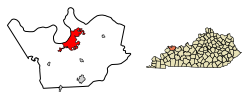
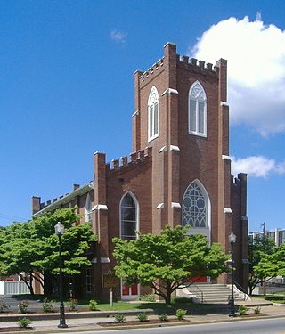
Henderson County is a county in the U.S. state of Kentucky. The county is located in western Kentucky on the Ohio River across from Evansville, Indiana. As of the 2020 census, the population was 44,793. Its county seat is Henderson.
Posey County is the southernmost, southwesternmost, and westernmost county in the U.S. state of Indiana. Its southern border is formed by the Ohio River, and its western border by the Wabash River, a tributary to the Ohio. As of 2020, the population was 25,222. The county seat is Mount Vernon.
Owensboro is a home rule-class city in and the county seat of Daviess County, Kentucky, United States. It is the fourth-most populous city in the state. Owensboro is located on U.S. Route 60 and Interstate 165 about 107 miles (172 km) southwest of Louisville, and is the principal city of the Owensboro metropolitan area. The 2020 census had its population at 60,183. The metropolitan population was estimated at 116,506. The metropolitan area is the sixth largest in the state as of 2018, and the seventh largest population center in the state when including micropolitan areas.
Rockport is a city in Ohio Township and the county seat of Spencer County, Indiana, along the Ohio River. The population was 2,270 at the 2010 census. Once the largest community in Spencer County, the city has recently been surpassed by the town of Santa Claus. At 37°53'1" north, Rockport is also the southernmost city in the state, located slightly south of Evansville, Cannelton, or Mount Vernon.
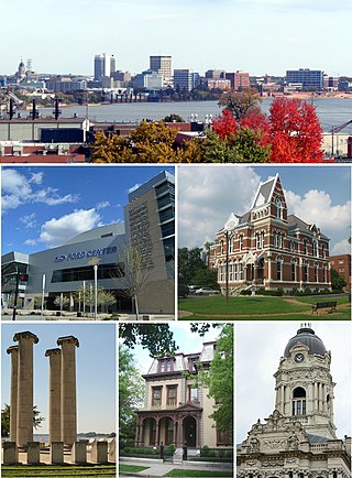
Evansville is a city in and the county seat of Vanderburgh County, Indiana, United States. With a population of 118,414 at the 2020 census, it is Indiana's third-most populous city after Indianapolis and Fort Wayne, the most populous city in Southern Indiana, and the 249th-most populous city in the United States. It is the central city of the Evansville metropolitan area, a hub of commercial, medical, and cultural activity of southwestern Indiana and the Illinois–Indiana–Kentucky tri-state area, which is home to over 911,000 people. The 38th parallel north crosses the north side of the city and is marked on Interstate 69.
Newburgh is a borough in Ohio Township, Warrick County, Indiana, United States, along the Ohio River. The population was 3,325 at the 2010 census, although the town is part of the larger Evansville metropolitan area which recorded a population of 342,815, and Ohio Township, which Newburgh shares with nearby Chandler, has a population of 37,749 in the 2010 census with over 17,000 of those living in the town and areas adjacent to the town. It is the easternmost suburb of Evansville.
Hopkinsville is a home rule-class city in and the county seat of Christian County, Kentucky, United States. The population at the 2020 census was 31,180.
Maysville is a home rule-class city in Mason County, Kentucky, United States, and is the seat of Mason County. The population was 8,873 as of the 2020 census. Maysville is on the Ohio River, 66 miles (106 km) northeast of Lexington. It is the principal city of the Maysville Micropolitan Statistical Area, which comprises Mason County. Two bridges cross the Ohio from Maysville to Aberdeen, Ohio: the Simon Kenton Memorial Bridge built in 1931 and the William H. Harsha Bridge built in 2001.
Henderson is a city in and the county seat of Chester County, Tennessee, United States. The population was 6,309 at the 2010 census, up from 5,670 at the 2000 census.
John James Audubon State Park is located on U. S. Route 41 in Henderson, Kentucky, just south of the Ohio River. Its inspiration is John James Audubon, the ornithologist, naturalist, and painter who resided in Henderson from 1810 to 1819 when Henderson was a frontier village.
The Henderson Gleaner is the daily newspaper in Henderson, Kentucky. The newspaper is published Tuesday through Sunday mornings. It has not been published on Mondays since it was founded in the 1880s.
The Bi-State Vietnam Gold Star Twin Bridges,, are located in Henderson County, Kentucky and connect Henderson, Kentucky, and Evansville, Indiana, along U.S. Route 41 (US 41), two miles (3.2 km) south of the current southern terminus of Interstate 69 (I-69). The two bridges average more than 40,000 vehicles crossings a day across the Ohio River.
Interstate 69 (I-69) in the US state of Kentucky is a 148.1-mile-long (238.3 km) freeway running from Fulton to Henderson. The route makes use of most of the Purchase Parkway and existing portions of I-24, the Western Kentucky Parkway, and the Pennyrile Parkway. Eventually, I-69 will leave the former Pennyrile Parkway just south of the Audubon Parkway interchange or remain on its current alignment and travel through Henderson on U.S. Route 41 (US 41) north into Indiana. The proposed route for the remainder of I-69 in Kentucky travels about 10 miles (16 km) to utilize an as-of-yet-unbuilt bridge into Indiana.
Southwestern Indiana is an 11-county region of southern Indiana, United States located at the southernmost and westernmost part of the state. As of the 2010 census, the region's combined population is 474,251. Evansville, Indiana's third-largest city, is the primary hub for the region, as well as the primary regional hub for a tri-state area that includes Kentucky and Illinois. Other regional hubs include Jasper, Vincennes, and Washington. Although part of a Midwestern state, this region's culture and language is aligned more with that of the Upland South rather than the Midwest.
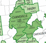
The Evansville metropolitan area is the 164th largest metropolitan statistical area (MSA) in the United States. The primary city is Evansville, Indiana, the third most populous city in Indiana and the most populous city in Southern Indiana as well as the hub for Southwestern Indiana. Other Indiana cities include Boonville, Mount Vernon, Jasper, Oakland City, Princeton, and Vincennes. Large towns in Indiana include Chandler, Fort Branch, McCutchanville, and Newburgh. Cities in Kentucky include Henderson, Dixon, Providence, and Robards and currently covers an area of 2,367 sq mi (6,130 km2). It is the primary metropolitan area in the Illinois–Indiana–Kentucky Tri-State Area.
U.S. Route 41 in the state of Kentucky is a north–south United States Numbered Highway that runs from Miami, Florida, to Copper Harbor, Michigan. In Kentucky, the highway is primarily paralleled by the Pennyrile Parkway and Interstate 69. It enters Kentucky in the Todd County community of Guthrie, and leaves the state north of Henderson into Evansville. The total length of US 41 through Kentucky is a total of 106.952 miles (172.123 km).
The following outline is provided as an overview of and topical guide to the United States Commonwealth of Kentucky:
The Interstate 69 Ohio River Crossing is a proposed bridge to carry the planned Interstate 69 (I-69) extension over the Ohio River between Evansville, Indiana, and Henderson, Kentucky. The bridge and its approach roadways make up a portion of Segment of Independent Utility 4 of the I-69 corridor from Michigan to Texas. It will be built approximately 1.62 miles (2.61 km) upstream of the existing Bi-State Vietnam Gold Star Bridges carrying U.S. Route 41 (US 41), at a point just downstream from where the Green River flows into the Ohio.