Aguadilla, founded in 1775 by Luis de Córdova, is a city and municipality located in the northwestern tip of Puerto Rico, bordered by the Atlantic Ocean to the north and west, north of Aguada, and Moca and west of Isabela. Aguadilla is spread over 15 barrios and Aguadilla Pueblo. It is a principal city and core of the Aguadilla-Isabela-San Sebastián Metropolitan Statistical Area.

La Fortaleza is the official residence of the governor of Puerto Rico and has been since the 16th century. It was built between 1533 and 1540 to defend the harbor of San Juan, in Puerto Rico. The structure is also known as Palacio de Santa Catalina. It is the oldest executive mansion in continuous use in the New World. It was listed by UNESCO in 1983 as part of the World Heritage Site "La Fortaleza and San Juan National Historic Site".

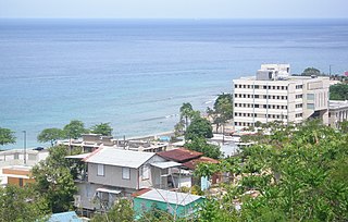
Isabela is a town and municipality of Puerto Rico located in the north-western region of the island, north of San Sebastián; west of Quebradillas; and east of Aguadilla and Moca. It is named in honor of Queen Isabella I of Castile. Isabela is spread over 13 barrios and Isabela Pueblo, which is the downtown area and administrative center. It is a principal part of the Aguadilla-Isabela-San Sebastián Metropolitan Statistical Area.
Aguada, originally San Francisco de Asís de la Aguada, is a town and municipality of Puerto Rico, located in the western coastal valley region bordering the Atlantic Ocean, east of Rincón, west of Aguadilla and Moca; and north of Añasco and Mayagüez. It is part of the Aguadilla-Isabela-San Sebastián Metropolitan Statistical Area. Aguada's population is spread over 17 barrios and Aguada Pueblo.

Old San Juan is a historic district located at the "northwest triangle" of the islet of San Juan in San Juan. Its area roughly correlates to the Ballajá, Catedral, Marina, Mercado, San Cristóbal, and San Francisco sub-barrios (sub-districts) of barrio San Juan Antiguo in the municipality of San Juan, Puerto Rico. Old San Juan is the oldest settlement within Puerto Rico and the historic colonial district of the city of San Juan. This historic district is a National Historic Landmark District and is listed on the United States National Register of Historic Places as the Old San Juan Historic District. Several historical buildings and structures, particularly La Fortaleza, the city walls, and El Morro and San Cristóbal castles, have been inscribed in the UNESCO World Heritage Site list since 1983. Historically the mixed use commercial and residential real estate in the main streets like Cristo Street, Fortaleza Street (north) from Tanca Street to the Governor’s Mansion is the most valuable in the area and it has kept its value and increased steadily through several years despite the past economic turmoils.

Guayama, officially the Autonomous Municipality of Guayama, is a city and municipality on the Caribbean coast of Puerto Rico. As of the 2020 U.S. Census, the city had a population of 36,614. It is the center of the Guayama metropolitan area with a population of 68,442 in 2020.
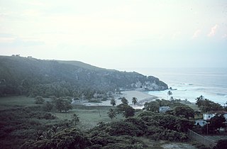
Quebradillas is a town and municipality of the island of Puerto Rico located in the north-western shore bordering the Atlantic Ocean, north of San Sebastián; east of Isabela; and west of Camuy. Quebradillas is spread over seven barrios and Quebradillas Pueblo. It is part of the San Juan-Caguas-Guaynabo Metropolitan Statistical Area.

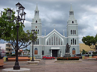
The Catholic Church in Puerto Rico is part of the worldwide Catholic Church in communion with the pope in Rome. The 78 municipalities in Puerto Rico have a Catholic church which is located in the downtown area, normally across from the central plaza.
The 1918 San Fermín earthquake, also known as the Puerto Rico earthquake of 1918, struck the island of Puerto Rico at on October 11. The earthquake measured 7.1 on the moment magnitude scale and IX (Violent) on the Mercalli intensity scale. The mainshock epicenter occurred off the northwestern coast of the island, somewhere along the Puerto Rico Trench.

This portion of National Register of Historic Places listings in Puerto Rico is along the north coast, north plains, and north slopes of the Cordillera, from Isabela to Guaynabo.

This is a list of properties and districts in the southern municipalities of Puerto Rico that are listed on the National Register of Historic Places. It includes places along the southern coast of the island, and on the south slope of Puerto Rico's Cordillera Central.

Porta del Sol, or simply West Region, is a tourism region in western Puerto Rico. Porta del Sol was the first tourism region to be established by the Puerto Rico Tourism Company. It consists of 17 municipalities in the western area: Quebradillas, Isabela, San Sebastián, Moca, Aguadilla, Aguada, Rincón, Añasco, Mayagüez, Las Marías, Maricao, Hormigueros, San Germán, Sabana Grande, Guánica, Lajas and Cabo Rojo.

Dorado barrio-pueblo is a barrio and the administrative center (seat) of Dorado, a municipality of Puerto Rico. Its population in 2010 was 780. It is one of the six barrios in the municipality of Dorado, Puerto Rico, along with Espinosa, Higuillar, Maguayo, Mameyal and Río Lajas.
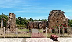
The Ermita Nuestra Señora de la Valvanera is a historic church in Coamo, Puerto Rico. It was built in 1685 and added to the National Register of Historic Places in 1986.
The Ermita Nuestra Señora de la Candelaria del Plantaje is a former church in the municipality of Toa Baja, Puerto Rico.

Isabela barrio-pueblo is a barrio and the administrative center (seat) of Isabela, a municipality of Puerto Rico. Its population in 2010 was 7,826.

Guayama barrio-pueblo is a barrio and the administrative center (seat) of Guayama, a municipality of Puerto Rico. Its population in 2010 was 16,891.

The Church of Nuestra Señora de las Mercedes de San Miguel de Hato Grande, also known as the Church Las Mercedes of San Lorenzo, is a historic Roman Catholic parish church located in San Lorenzo Pueblo, the administrative and historic center of the municipality of San Lorenzo, Puerto Rico. Las Mercedes was named in honor of both the Virgin Mary and Doña Mercedes Delgado Manso, the wife of the then mayor of San Lorenzo and a descendant of Don Sebastián Delgado Manso, one of the founders of the city of Caguas.