
Anne Arundel County, also notated as AA or A.A. County, is a county located in the U.S. state of Maryland. As of the 2010 United States Census, its population was 537,656, a population increase of just under 10% since 2000. Its county seat is Annapolis, which is also the capital of the state. The county is named for Lady Anne Arundell (1615–1649), a member of the ancient family of Arundells in Cornwall, England, and the wife of Cecilius Calvert, 2nd Baron Baltimore (1605–1675), founder and first Lord Proprietor of the colony Province of Maryland.

Queen Anne's County is a county located in the U.S. state of Maryland. As of the 2010 census, the population was 47,798. Its county seat and most populous municipality is Centreville. The census-designated place of Stevensville is the county's most populous place. The county is named for Queen Anne of Great Britain who reigned when the county was established in 1706.

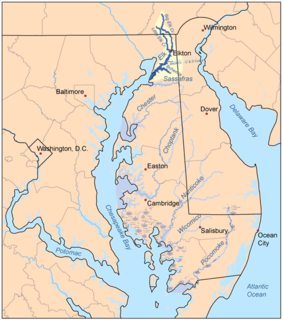
The Delmarva Peninsula, or simply Delmarva, is a large peninsula on the East Coast of the United States, occupied by Delaware and parts of the Eastern Shores of Maryland and Virginia. The peninsula is 170 miles (274 km) long. In width, it ranges from 70 miles (113 km) near its center, to 12 miles (19 km) at the isthmus on its northern edge, to less near its southern tip of Cape Charles. It is bordered by the Chesapeake Bay on the west, the Delaware River, Delaware Bay, and the Atlantic Ocean on the east, and the Elk River and its isthmus on the north.
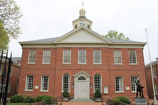
Talbot County is a county located in the heart of the Eastern Shore of Maryland in the U.S. state of Maryland. As of the 2010 census, the population was 37,782. Its county seat is Easton. The county was named for Lady Grace Talbot, the wife of Sir Robert Talbot, an Anglo-Irish statesman, and the sister of Lord Baltimore.

Queen Anne is a town in Queen Anne's and Talbot counties in the U.S. state of Maryland. The population was 222 at the 2010 census.

The Eastern Shore of Maryland is a part of the U.S. state of Maryland that lies predominantly on the east side of the Chesapeake Bay and consists of nine counties. As of the 2010 census, its population was 449,226, with just under 8 percent of Marylanders living in the region. The term "Eastern Shore" distinguishes a territorial part of the State of Maryland from the Western Shore of Maryland, land west of the Chesapeake Bay.

Wye Mills is an unincorporated community in Talbot County, Maryland, United States, located at an altitude of 20 feet (6.1 m). Wye Mills is located at the intersection of Maryland Route 662 and Maryland Route 404 just south of the Queen Anne's County border.
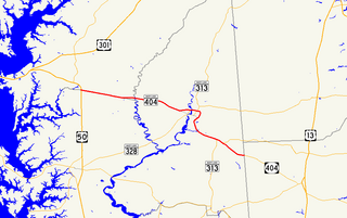
Maryland Route 404 is a major highway on Maryland's Eastern Shore in the United States. It runs 24.61 miles (39.61 km) from MD 662 in Wye Mills on the border of Queen Anne's and Talbot counties, southeast to the Delaware state line in Caroline County, where the road continues as Delaware Route 404 to Five Points. The Maryland and Delaware state highways together cross the width of the Delmarva Peninsula and serve to connect the cities west of the Chesapeake Bay by way of the Chesapeake Bay Bridge and U.S. Route 50 with the Delaware Beaches. Along the way, MD 404 passes through mostly farmland and woodland as well as the towns of Queen Anne, Hillsboro, and Denton. The route is a four-lane divided highway between US 50 and east of Denton, with the remainder of the route a two-lane undivided road.
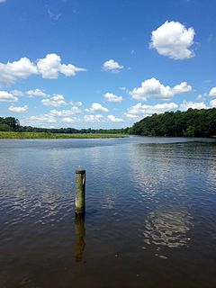
The Wye River is a 16.3-mile-long (26.2 km) tributary of the Chesapeake Bay, on the Eastern Shore of Maryland. It was named by the Lloyd family, Edward Lloyd (delegate), and Edward Lloyd, after the River Wye in the United Kingdom. It falls within Queen Anne's County and Talbot County, and joins the Miles River near its mouth to the Eastern Bay. The river is popular with recreational boaters because of its secluded anchorages, fishing, crabbing and proximity to the tourist attractions of St. Michaels, Maryland. Like many rivers on the Chesapeake Bay, the Wye is largely tidal. The river's features include the 2,800-acre (11 km2) Wye Island, most of which is part of the Wye Island Natural Resources Management Area, managed by the Maryland Department of Natural Resources State Forest and Park Service. William Paca, the third governor of Maryland and a signatory to the Declaration of Independence, once owned the island.
The Elk River is a tidal tributary of the Chesapeake Bay on the Eastern Shore of Maryland and on the northern edge of the Delmarva Peninsula. It is about 15 miles (24 km) long. As the most northeastern extension of the Chesapeake Bay estuary, it has served as one entrance to the Chesapeake & Delaware Canal since the 19th century. The canal and river now serve as one boundary of the Elk Neck Peninsula. The river flows through Cecil County, Maryland, with its watershed extending into New Castle County, Delaware and Chester County, Pennsylvania. Elkton, the county seat of Cecil County, is located at its head. Its total watershed area is 143 square miles (370 km2), with 21 square miles (54 km2) of open water, so its watershed is 15% open water. It is south and east of the North East River, and north of the Sassafras River.

The Eastern Bay is a tributary of the Chesapeake Bay located between Queen Anne's County, Maryland and Talbot County, Maryland on the Eastern Shore. Its main tributaries include the Miles River and the Wye River. It is located south of the Chester River and north of the Choptank River and is connected to the Chester River via Kent Narrows.
The Narrows is most notably the name of a strait in New York City separating Brooklyn and Staten Island.

The log canoe is a type of sailboat developed in the Chesapeake Bay region. Based on the dugout, it was the principal traditional fishing boat of the bay until superseded by the bugeye and the skipjack. However, it is most famous as a racing sailboat, and races continue to be held.
Tuckahoe Creek is a 21.5-mile-long (34.6 km) tributary of the Choptank River on Maryland's Eastern Shore. It is sometimes (erroneously) referred to as the Tuckahoe River. Upstream of Hillsboro, it forms the boundary between Caroline County and Queen Anne's County, passing through Tuckahoe State Park and dividing the small towns of Queen Anne and Hillsboro. Downstream of Hillsboro, it forms the boundary between Caroline County and Talbot County, before flowing into the Choptank.
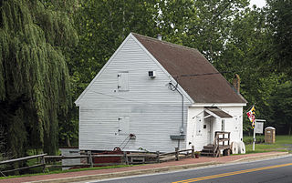
The Wye Mill is the oldest continuously operated grist mill in the United States, located at Wye Mills, Queen Anne's County and Talbot County, Maryland, United States. It is the earliest industrial site on the Eastern Shore in continuous use; dating to the late 17th century. It is a wood-frame, water-powered grist mill, with a 19th-century 26 HP 10-foot-diameter (3.0 m) Fitz steel overshot wheel. The mill retains nearly all of its late-18th-century equipment. The Wye Mill was one of the first grist mills to be automated with the Oliver Evans process, which is still in use today.

The 1964 United States presidential election in Maryland took place on November 3, 1964, as part of the 1964 United States presidential election. Maryland voters chose ten representatives, or electors, to the Electoral College, who voted for president and vice president.
