Hiking, rock climbing, and mountain climbing around Tuolumne Meadows

Last updated
Sunset over Tuolumne River by Tuolumne Meadows Tuolumne Meadows Sunset.jpg
Sunset over Tuolumne River by Tuolumne Meadows

Hiking, rock climbing, and mountain climbing around Tuolumne Meadows in Yosemite National Park has many options.

Contents

Hiking and rock climbing, a note on granite domes

Granite domes are common in Tuolumne, and, throughout Yosemite National Park. There is a separate page, all about granite domes of Yosemite. At present, its references focus on rock climbing, but others are free, to add references about hiking. It is available under Granite Domes of Yosemite National Park, as the page is not specific to Tuolumne Meadows; the table of domes may be sorted, so you may look at a chosen area.

Hiking

Many backcountry hiking and backpacking trails start in or near Tuolumne Meadows. The John Muir Trail and the Pacific Crest Trails are long-distance backpacking trails that go through Lyell Canyon into Tuolumne Meadows. Tuolumne Meadows also feature a wide range of day trails. Day hike trails are popular, [1] [2] [3] and get busy in the summer high season. These trails are serviced by the Tuolumne Meadows shuttle bus, typically from June to September, though dates vary due to weather. [4]

Lower Cathedral Lake, in the foreground, occupies a basin excavated in the granite by the ancient glaciers. Cathedral Peak is behind, Eichorn Pinnacle visible, just left of the summit. Both are nunataks. Cathedral Peak and Lake in Yosemite.jpg
Lower Cathedral Lake, in the foreground, occupies a basin excavated in the granite by the ancient glaciers. Cathedral Peak is behind, Eichorn Pinnacle visible, just left of the summit. Both are nunataks.

Hiking destinations:

Rock climbing

Stately Pleasure Dome - Hermaphrodite Flake Tuolumne Meadows - Stately Pleasure Dome - Hermaphrodite Flake - Pitch 2 - 1.JPG
Stately Pleasure Dome - Hermaphrodite Flake

In Tuolumne, rock climbing is popular, [40] [41] [42] and there are many granite domes, there and elsewhere in Yosemite. [43]

In contrast to the big walls of Yosemite Valley, climbing at Tuolumne generally consists of short- to medium-length routes on eleven major domes and several minor ones; see Granite Domes of Yosemite National Park. As the area is all at a high elevation, climbing season is mainly limited to June through September.

In Tuolumne, granite tends to be knobby, moreso than Yosemite Valley. [44] [40] [45]

The rock is porphyritic granite, a very strong form of granite, plus granodiorite; see Cathedral Peak Granodiorite and Kuna Crest Granodiorite. It has a tendency to exfoliation, which produces and preserves distinctive "onion dome" shapes. Resulting climbing includes both face and crack routes, face routes often runout due to limited numbers of bolts, and crack routes frequently following very thin cracks. Local ethic is to limit the placement of bolts on new routes and to forbid the addition of bolts to existing routes, resulting in distances of 40 feet (12 m) or more between bolts. [46]

Many domes are in Tuolumne area. [47] Major (and minor) domes include:

Echo Peaks have been hiked, [74] but are usually rock-climbed, as Ragged Peak may be scrambled, but is also rock climbed. [75] Mountain that are not usually walk-ups, but typically rock-climbs:

Mountain climbing

Around Tuolumne Meadows, mountain climbing is quite popular; [85] for the highest mountains in the entire park, see the highest mountains of Yosemite National Park.

The symbol of Yosemite: Half Dome, which may be hiked, via the Cable Route. Behind Half Dome is Clouds Rest, the highest point visible from Yosemite Valley. Taken from Glacier Point, to which from Yosemite Valley may be hiked, via the Four Mile Trail. Half Dome from Glacier Point, Yosemite NP - Diliff.jpg
The symbol of Yosemite: Half Dome, which may be hiked, via the Cable Route. Behind Half Dome is Clouds Rest, the highest point visible from Yosemite Valley. Taken from Glacier Point, to which from Yosemite Valley may be hiked, via the Four Mile Trail.

A few mountains that can be climbed, out of Tuolumne Meadows:

See also

Related Research Articles

<span class="mw-page-title-main">Tuolumne Meadows</span> Meadow in Yosemite National Park, US

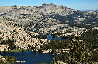
Tuolumne Meadows is a gentle, dome-studded, sub-alpine meadow area along the Tuolumne River in the eastern section of Yosemite National Park in the United States. Its approximate location is 37°52.5′N119°21′W. Its approximate elevation is 8,619 feet (2,627 m). The term Tuolumne Meadows is also often used to describe a large portion of the Yosemite high country around the meadows, especially in context of rock climbing.

<span class="mw-page-title-main">Mount Lyell (California)</span> Mountain in the American state of California

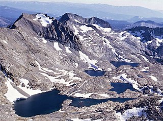
Mount Lyell is the highest point in Yosemite National Park, at 13,114 feet (3,997 m). It is located at the southeast end of the Cathedral Range, 1+14 miles northwest of Rodgers Peak. The peak as well as nearby Lyell Canyon is named after Charles Lyell, a well-known 19th century geologist. The peak had one of the last remaining glaciers in Yosemite, Lyell Glacier. The Lyell Glacier is currently considered to be a permanent ice field, not a living glacier. Mount Lyell divides the Tuolumne River watershed to the north, the Merced to the west, and the Rush Creek drainage in the Mono Lake Basin to the southeast.

<span class="mw-page-title-main">Pothole Dome</span>

Pothole Dome is a granite dome on the west side of Tuolumne Meadows, in Yosemite National Park located at Tioga Road mile marker 18. Near Pothole Dome is Marmot Dome. The summit of the dome is easily accessible by foot from a parking area on the Tioga Road at mile marker 18. The view from the summit includes most of Tuolumne Meadows and in the distance, Cathedral Peak. The dome gives evidence of many of the geologic processes at work in Yosemite during and after the last ice age. In particular, the stranded, rounded boulders from a glacier that has long since retreated, and the water-eroded "potholes" provide evidence of two ways that water can interact with granite.

<span class="mw-page-title-main">North face (Fairview Dome)</span> Climbing route in Yosemite National Park, US

The North Face of Fairview Dome also known as the Regular Route of Fairview Dome is a technical rock climbing route in Tuolumne Meadows of Yosemite National Park. It is featured in Fifty Classic Climbs of North America.

<span class="mw-page-title-main">Johnson Peak</span> Johnson Peak is mountain peak, in Yosemite National Park, in the Tuolumne Meadows area

Johnson Peak is the highest mountain, in Tuolumne Meadows, Yosemite National Park.

<span class="mw-page-title-main">Tuolumne Peak</span> Tuolumne Peak is mountain peak, in Yosemite National Park, in the Tuolumne Meadows area

Tuolumne Peak is a mountain, in Yosemite National Park, in the area of Tuolumne Meadows. It is a fractured granite, twin summited peak, and is close to geographic center of the park. Tuolumne Peak is located approximately 2.5 miles (4.0 km) northeast of Mount Hoffmann via a granite ridge-line. It is climbed less often than Hoffman, probably due to a more difficult approach.

<span class="mw-page-title-main">Elizabeth Lake (Yosemite National Park)</span>

Elizabeth Lake is a lake, in the area of Tuolumne Meadows, in Yosemite National Park, California. It was named for a geologist's niece, one Elizabeth Crow Simmons. The lake is at the base of Unicorn Peak, and is also near Johnson Peak.

Dozier Dome is a granite dome, in the Tuolumne Meadows region of Yosemite National Park. It is named after Jeff Dozier.

Mariolumne Dome is a granite dome, in the Tuolumne Meadows region of Yosemite National Park.

<span class="mw-page-title-main">Puppy Dome</span> Puppy Dome is a granite dome, in Yosemite National Park, in the Tuolumne Meadows area

Puppy Dome is a granite dome in Tuolumne Meadows, Yosemite National Park, California.

<span class="mw-page-title-main">Echo Peaks</span> Nine mountains near Tuolumne Meadows, in Yosemite National Park, California

Echo Peaks consists of nine peaks, in the Tuolumne Meadows region of Yosemite National Park, California. They are near Echo Ridge.

<span class="mw-page-title-main">Mammoth Peak</span> Mountain in Yosemite National Park

Mammoth Peak is a mountain in the area of Tuolumne Meadows, Yosemite National Park, California. The summit is a class 1-2 cross-country hike that features river crossings and boulder scrambling. The peak lies at the northern end of the Kuna Crest and is close to California State Route 120. From the road, its summit appears rounded and quite rocky. Though Mammoth Peak is not as popular as other nearby peaks, its relatively easily accessed summit affords tremendous views of Mount Gibbs, Mount Dana, and Mount Lewis.

<span class="mw-page-title-main">Kuna Crest</span> Mountain range near Tuolumne Meadows, in Yosemite National Park, California

Kuna Crest is a mountain range near Tuolumne Meadows, in Yosemite National Park, California.

<span class="mw-page-title-main">Unicorn Peak (California)</span> Unicorn Peak is mountain peak, in Yosemite National Park, in the Tuolumne Meadows area

Unicorn Peak is a peak, in Tuolumne Meadows, Yosemite National Park. Unicorn Peak is due east of Cathedral Peak, and the north summit is highest.

North Whizz Dome is a granite dome in the Tuolumne Meadows area of Yosemite National Park. North Whizz Dome is a bit south, of Cathedral Creek, which has its source, near Cathedral Peak. North Whizz Dome Dome is north of both Medlicott Dome and Pywiack Dome, both of which are south of California State Route 120, which runs through Tuolumne Meadows to Tioga Pass. It is near Hammer Dome, also, Daff Dome and Polly Dome are nearby.

South Whizz Dome is a granite dome in the Tuolumne Meadows area of Yosemite National Park. South Whizz Dome is a bit south, of Cathedral Creek, which has its source, near Cathedral Peak. South Whizz Dome Dome is north of both Medlicott Dome and Pywiack Dome, both of which are south of California State Route 120, which runs through Tuolumne Meadows to Tioga Pass. It is near Hammer Dome, also, Daff Dome and Polly Dome are nearby.

Lamb Dome Dome is a granite dome, in the Tuolumne Meadows area of Yosemite National Park. It is one of the smaller domes.

<span class="mw-page-title-main">Ragged Peak (Yosemite National Park)</span> Ragged Peak is mountain in Yosemite National Park, in the Tuolumne Meadows area

Ragged Peak is a mountain, in the Tuolumne Meadows area of Yosemite National Park.

<span class="mw-page-title-main">Electra Peak</span> Electra Peak is mountain in Yosemite National Park, in the Tuolumne Meadows area

Electra Peak is a mountain, broadly in the Tuolumne Meadows area of Yosemite National Park, if far, from the road. Electra Peak is the 14th highest mountain in Yosemite National Park.

<span class="mw-page-title-main">Donohue Peak (Yosemite)</span> Mountain in eastern Yosemite National Park, near Tuolumne Meadows

Donohue Peak is a mountain, in the northern part of Yosemite National Park. Donohue Peak is along Yosemite National Park's eastern border, in the area of Tuolumne Meadows.

References

  1. "Tuolumne Meadows Map and Area Information" (PDF). yosemite.com. Retrieved 29 January 2019.
  2. "Hiking around Tuolumne Meadows and the Tioga Road". americansouthwest.net. Retrieved 29 January 2019.
  3. Bates, Shawn (2015-10-20). "Signature Day Hikes in Yosemite's Tuolumne Meadows, California". Sierra Club. Retrieved 29 January 2019.
  4. "Day Hikes in Tuolumne Meadows - Yosemite National Park (U.S. National Park Service)". www.nps.gov. Retrieved 2018-05-16.
  5. "Cathedral Lakes". yosemitehikes.com. Retrieved 28 January 2019.
  6. "Conness Glacier - Mono County, CA". trails.com. Retrieved 28 January 2019.
  7. "Photographs of Tuolumne Meadows and the Tioga Road, Yosemite National Park". americansouthwest.net. Retrieved 29 January 2019.
  8. "Photographs of the Mount Dana Trail, Yosemite National Park". americansouthwest.net. Retrieved 29 January 2019.
  9. "Dana Meadows Topo Map in Tuolumne County CA". topozone.com. Retrieved 29 January 2019.
  10. "Dog Lake Trail". alltrails.com. Retrieved 28 January 2019.
  11. "Tuolumne Meadows to Elizabeth Lake: Out-N-Back". hikingproject.com. 2019. Retrieved 28 January 2019.
  12. "Gaylor Lakes". yosemitehikes.com. Retrieved 28 January 2019.
  13. "Guide to Tuolumne Meadows Trails (1960) by Allan Shields". yosemite.ca.us. Retrieved 28 January 2019.
  14. "Glen Aulin Trail Map". yosemitehikes.com. Retrieved 28 January 2019.
  15. "Glen Aulin (Tuolumne Falls & White Cascade)". yosemitehikes.com. Retrieved 28 January 2019.
  16. "Harvey Monroe Hall RNA". US Forest Service. Retrieved 29 January 2019.
  17. "Hall Natural Area". allmammoth.com. Retrieved 29 January 2019.
  18. "Harvey Monroe Hall Research Natural Area". naturalatlas.com. Retrieved 29 January 2019.
  19. "HARVEY MONROE HALL RESEARCH NATURAL AREA MANAGEMENT PLAN" (PDF). fs.fed.us. Retrieved 29 January 2019.
  20. "John Muir Trail: Tuolumne Meadows to Devils Postpile". BACKPACKERMagazine. Retrieved 28 January 2019.
  21. "John Muir Trail: Happy Isles to Tuolumne Meadows". alltrails.com. Retrieved 28 January 2019.
  22. "Lyell Canyon". yosemitehikes.com. Retrieved 28 January 2019.
  23. "Thru-Hiking the JMT: Tuolumne to Upper Lyell Canyon". socalhiker.net. Retrieved 28 January 2019.
  24. Church, Michael W. (2014). "Horse Riding and Mule Packing in the Ansel Adams Wilderness". equitrekking.com. Retrieved 29 January 2019.
  25. 1 2 3 "Day Hikes in Tuolumne Meadows". nps.gov. Retrieved 28 January 2019.
  26. "Mono Pass". yosemitehikes.com. Retrieved 28 January 2019.
  27. "VI. MONO PASS AND HISTORIC GOLDEN CROWN MINES". yosemite.ca.us. Retrieved 28 January 2019.
  28. 1 2 "Soda Springs and Parsons Lodge Trail". alltrails.com. Retrieved 28 January 2019.
  29. Reid, Robert. "Soda Springs (1.5 miles roundtrip)". National Geographic. Retrieved 30 January 2019.
  30. "Lembert the Lepidopterist". yosemiteconservancy.org. August 17, 2018. Retrieved 29 January 2019.
  31. "NATIONAL REGISTER OF HISTORIC PLACES INVENTORY - NOMINATION FORM". npgallery.nps.gov. April 19, 1975. Retrieved 29 January 2019.
  32. "3 Stops on Tioga Road in Yosemite". myyosemitepark.com. May 17, 2018. Retrieved 29 January 2019.
  33. "Tioga Road Opening & Closing Dates". NPS. Retrieved 29 January 2019.
  34. "Tioga Pass/Tuolumne Meadows". yosemite.com. 2019. Retrieved 29 January 2019.
  35. "Young Lakes". highsierratrails.com. Retrieved 29 January 2019.
  36. "The Trail from Tuolumne Meadows to Young Lakes". HighSierraTrails. Retrieved 29 January 2019.
  37. "Young Lakes, Yosemite National Park". americansouthwest.net. Retrieved 29 January 2019.
  38. "Yosemite National Park: Young Lakes Loop". backpacker.com. 2019. Retrieved 29 January 2019.
  39. "Young Lakes Trail". hikingproject.com. Retrieved 29 January 2019.
  40. 1 2 Janes, Josh. "Tuolumne Meadows Rock Climbing". mountainproject.com. Retrieved 29 January 2019.
  41. "Tuolumne Meadows Mostly Rock climbing". thecrag.com. Retrieved 29 January 2019.
  42. "Tuolumne Meadows Ascents Climbing Sections". rockclimbing.com. 2019. Retrieved 29 January 2019.
  43. "Domes, Yosemite". peakbagger.com. Retrieved 3 February 2019.
  44. "Tuolumne Rock Climbing Info". supertopo.com. Retrieved 1 February 2019.
  45. "Rock climbing at Tuolumne Meadows". climb-europe.com. Retrieved 1 February 2019.
  46. Reid, Don; Chris Falkenstein (1986). Rock Climbs of Tuolumne Meadows. Chockstone Press. p. 160. ISBN   978-0-934641-01-2.
  47. Retemeyer, Jim (2019). "Domes in Yosemite". peakbagger.com. Retrieved 28 January 2019.
  48. "Daff Dome". rockclimbing.com. 2019. Retrieved 28 January 2019.
  49. "Dozier Dome". summitpost.org. Retrieved 28 January 2019.
  50. "Dozier Dome Rock Climbing". mountainproject.com. Retrieved 28 January 2019.
  51. "Dozier Dome Climbing Sections". rockclimbing.com. Retrieved 28 January 2019.
  52. "Regular Route, Fairview Dome 5.9". supertopo.com. 2019. Retrieved 28 January 2019.
  53. "Fairview Dome California, United States, North America". summitpost.org. Retrieved 28 January 2019.
  54. "Fairview Dome Rock Climbing". .mountainproject.com. Retrieved 28 January 2019.
  55. "The Sting, Harlequin Dome 5.10b R". supertopo.com. 2019. Retrieved 28 January 2019.
  56. Josh. "Lembert Dome: Hiking Tuolumne Meadows Famous Granite Dome". californiathroughmylens.com. Retrieved 28 January 2019.
  57. "Lembert Dome". yosemitehikes.com. Retrieved 28 January 2019.
  58. "Lembert Dome Climbing Sections". rockclimbing.com. Retrieved 28 January 2019.
  59. Blitzo. "Lembert Dome Rock Climbing". mountainproject.com. Retrieved 28 January 2019.
  60. "Mariolumne Dome Climbing Sections". rockclimbing.com. Retrieved 28 January 2019.
  61. Keyser, Joe. "Mariuolumne Dome Rock Climbing". mountainproject.com. Retrieved 28 January 2019.
  62. Lautzenheiser, Dan. "Marmot Dome Rock Climbing". mountainproject.com. Retrieved 28 January 2019.
  63. Misha. "Medlicott Dome". summitpost.org. Retrieved 28 January 2019.
  64. 1 2 "Polly Dome". rockclimbing.com. Retrieved 28 January 2019.
  65. "Pothole Dome & Tuolumne River". yosemitehikes.com. Retrieved 28 January 2019.
  66. "Pothole Dome Trail Map". yosemitehikes.com. Retrieved 28 January 2019.
  67. "Pothole Dome Trail". alltrails.com. 2019. Retrieved 28 January 2019.
  68. Fox, Emily (2019). "Pothole Dome Rock Climbing". mountainproject.com. Retrieved 28 January 2019.
  69. "Pothole Dome Climbing Sections". rockclimbing.com. Retrieved 28 January 2019.
  70. Marcsoltan. "Puppy Dome". summitpost.org. Retrieved 28 January 2019.
  71. "Climb Hermaphrodite Flake to Boltway in Yosemite National Park". theoutbound.com. 2019. Retrieved 28 January 2019.
  72. Larson, Steve. "summitpost.org". Stately Pleasure Dome. Stately Pleasure Dome. Retrieved 29 January 2019.
  73. Wilder, Nick. "Stately Pleasure Dome Rock Climbing". mountainproject.com. Retrieved 29 January 2019.
  74. Burd, Bob. "Echo Peaks, California, United States, North America". summitpost.org. Retrieved 4 February 2019.
  75. Fedak. "summitpost.org". Ragged Peak, California, United States, North America. summitpost.org. Retrieved 6 March 2019.
  76. "Cockscomb". summitpost.org. Retrieved 28 January 2019.
  77. "Echo Peaks California, United States, North America". summitpost.org. Retrieved 29 January 2019.
  78. "Echo Peaks Traverse". peaksforfreaks.blogspot.com. Retrieved 29 January 2019.
  79. Ajani, Jade. "Echo Peaks Rock Climbing". mountainproject.com. Retrieved 29 January 2019.
  80. "Echo Ridge, Echo Peaks". alltrails.com. Retrieved 29 January 2019.
  81. Burd, Bob. "Unicorn Peak California, United States, North America". summitpost.org. Retrieved 31 January 2019.
  82. Hau, Keung (June 17, 2014). "Unicorn Peak". YouTube. Retrieved 31 January 2019.
  83. California Through My Lens (October 6, 2017). "2 Days in Yosemite High Country: Unicorn Peak, Fly Fishing & North Dome". YouTube. Retrieved 31 January 2019.
  84. Reese, Madelyn (September 8, 2016). "The Tatoosh range is a peak bagger's paradise". tdn.com. Retrieved 31 January 2019.
  85. "Yosemite's Highest Peaks". summitpost.org. Retrieved 29 January 2019.
  86. Burd, Bob. "Cathedral Peak California, United States, North America". summitpost.org. Retrieved 28 January 2019.
  87. "Scramble Yosemite's Cathedral Peak". theoutbound.com. Retrieved 28 January 2019.
  88. Wilder, Nick. "Southeast Buttress". mountainproject.com. Retrieved 28 January 2019.
  89. "SE Buttress". summitpost.org. Retrieved 28 January 2019.
  90. Wilder, Nick. "Cathedral Peak Rock Climbing". mountainproject.com. Retrieved 28 January 2019.
  91. Kish, Bill. "Echo Ridge California, United States, North America". summitpost.org. Retrieved 31 January 2019.
  92. "Echo Ridge & Echo Peaks". AllTrails. Retrieved 31 January 2019.
  93. Hau, Keung (July 8, 2014). "Echo Ridge and Echo Peaks". YouTube. Retrieved 31 January 2019.
  94. Hunewill, Blair (May 31, 2015). "Echo Ridge Summit". YouTube. Retrieved 31 January 2019.
  95. "Echo Ridge Noondueler Noondueler". summitpost.org. Retrieved 31 January 2019.
  96. Noondueler. "False White Mountain, California, United States". summitpost.org. Retrieved 31 January 2019.
  97. Alpinist. "Johnson Peak (Yosemite)". summitpost.org. Retrieved 29 January 2019.
  98. "Johnson Peak, California". peakbagger.com. 2019. Retrieved 29 January 2019.
  99. "Kuna Peak California, United States, North America". summitpost.org. Retrieved 29 January 2019.
  100. "Kuna Peak, California". peakbagger.com. 2019. Retrieved 29 January 2019.
  101. "Kuna Crest Traverse - Mammoth Peak to Kuna Peak". mountainproject.com. Retrieved 29 January 2019.
  102. "Mammoth Peak California, United States, North America". summitpost.org. Retrieved 31 January 2019.
  103. pos315 (June 3, 2013). "Mammoth Peak, Tioga Pass, Yosemite NP". YouTube. Retrieved 31 January 2019.
  104. Slicktode (June 7, 2018). "Mammoth Peak Yosemite National Park 117 views". YouTube. Retrieved 31 January 2019.
  105. Ramey, Jordan. "Matthes Crest Traverse - South to North". mountainproject.com. Retrieved 29 January 2019.
  106. Ramey, Jordan. "Matthes Crest Rock Climbing". mountainproject.com. Retrieved 29 January 2019.
  107. "Traverse from South to North, Matthes Crest 5.7". supertopo.com. 2019. Retrieved 29 January 2019.
  108. "Matthes Crest". summitpost.org. Retrieved 29 January 2019.
  109. "Matthes Crest Traverse". outdoorproject.com. Retrieved 29 January 2019.
  110. "Matterhorn Peak California, United States, North America". summitpost.org. Retrieved 30 January 2019.
  111. "Matterhorn Peak". alltrails.com. Retrieved 30 January 2019.
  112. "Matterhorn Peak, California". peakbagger.com. Retrieved 30 January 2019.
  113. "Mount Conness California, United States, North America". summitpost.org. Retrieved 29 January 2019.
  114. "Yosemite National Park: Mount Conness". BackpackerMagazine. Retrieved 29 January 2019.
  115. Myers, Joseph. "West Ridge". mountainproject.com. Retrieved 29 January 2019.
  116. "Mount Conness, California". peakbagger.com. Retrieved 29 January 2019.
  117. Jack and Barb (Jun 25, 2009). "Matterhorn Peak". YouTube. Retrieved 30 January 2019.
  118. "Climb Matterhorn Peak via the East Couloir". theoutbound.com. Retrieved 30 January 2019.
  119. "Matterhorn Peak Route". yosemitenews.info. Retrieved 30 January 2019.
  120. "Mount Dana Summit Trail". alltrails.com. Retrieved 29 January 2019.
  121. "Mount Dana Trail, Yosemite National Park". americansouthwest.net. 2019. Retrieved 29 January 2019.
  122. "Mount Dana, California". peakbagger.com. 2019. Retrieved 29 January 2019.
  123. McCarthy, Guy (September 22, 2017). "OUT THERE: Backcountry ventures in the Central Sierra". uniondemocrat.com. Retrieved 29 January 2019.
  124. steeleman. "Mount Dana California, United States, North America". summitpost.org. Retrieved 29 January 2019.
  125. Moffat, Corey. "Mount Dana Backcountry Ski". outdoorproject.com. Retrieved 29 January 2019.
  126. Mrchad9. "Mount Florence". summitpost.org. Retrieved 28 January 2019.
  127. HenneB. "Mount Gibbs California, United States, North America". summitpost.org. Retrieved 29 January 2019.
  128. "Mount Gibbs 2014 California, United States, North America". summitpost.org. Retrieved 29 January 2019.
  129. "Mount Gibbs, California". peakbagger.com. 2019. Retrieved 29 January 2019.
  130. Burd, Bob. "Mount Lyell California, United States, North America". summitpost.org. Retrieved 30 January 2019.
  131. "Mount Lyell". alltrails.com. Retrieved 30 January 2019.
  132. "Mount Lyell, the highest peak in Yosemite National Park". allyosemite.com. Retrieved 30 January 2019.
  133. "Mount Lyell from Tuolumne Meadows via Lyell Canyon". yosemiteexplorer.com. Retrieved 30 January 2019.
  134. sfguy00777 (June 25, 2012). "Top of Mt. Lyell @ 13,114 Feet- Highest Point in Yosemite 6/24/12". YouTube. Retrieved 30 January 2019.
  135. "Mount Lyell, California, Elevation: 13,114 feet (3,997 meters)". peakbagger.com. Retrieved 30 January 2019.
  136. 1 2 Miller, Jeremy (May 26, 2013). "California's Vanishing Glaciers: A Defining Moment". California’s Vanishing Glaciers: A Defining Moment. kqed.org. Retrieved 30 January 2019.
  137. "Mount Maclure California, United States, North America". summitpost.org. Retrieved 30 January 2019.
  138. Andronova, Olya (July 7, 2017). "Mount Maclure. Lyell Canyon via John Muir Trail. Yosemite National Park". YouTube. Retrieved 30 January 2019.
  139. "North Peak, California, United States, North America". summitpost.org. Retrieved 30 January 2019.
  140. Albers, J. "North Peak Climbing". mountainproject.com. Retrieved 30 January 2019.
  141. "North Peak, California". peakbagger.com. Retrieved 30 January 2019.
  142. Whitney, Branch (August 2, 2014). "View from North Peak in Yosemite". YouTube. Retrieved 30 January 2019.
  143. Kim, Yongsung (September 17, 2018). "Backpacking 20 Lakes Basin, Conness Lakes and North Peak, Yosemite East". YouTube. Retrieved 30 January 2019.
  144. "Parsons Peak California, United States, North America". summitpost.org. Retrieved 30 January 2019.
  145. Holliman, Matthew. "Rodgers Peak California, United States, North America". summitpost.org. Retrieved 31 January 2019.
  146. Fleck, Rudy (August 20, 2013). "Rodgers Peak : Electra Peak : Bench Canyon". YouTube. Retrieved 31 January 2019.
  147. "Tioga Peak California, United States, North America". summitpost.org. Retrieved 30 January 2019.
  148. "Tresidder Peak California, United States, North America". summitpost.org. Retrieved 31 January 2019.
  149. "Tuolumne Peak Rock Climbing". mountainproject.com. Retrieved 31 January 2019.
  150. Hau, Keung (June 19, 2012). "Tuolumne Peak (10845ft)". YouTube. Retrieved 31 January 2019.
  151. Burd, Bob. "Vogelsang Peak California, United States, North America". summitpost.org. Retrieved 31 January 2019.
  152. Katcher, Brandon. "Vogelsang Peak Yosemite National Park". outdoorproject.com. Retrieved 31 January 2019.
  153. Johnsen, Justin (December 6, 2018). "Vogelsang Peak Rock Climbing". Mountain Project. Retrieved 31 January 2019.
  154. "Vogelsang Peak, California". peakbagger.com. 2004-11-01. Retrieved 31 January 2019.
  155. Irwin, Brian. "Get high on Yosemite with a backcountry hike and climb". Dallas News. Retrieved 31 January 2019.
  156. Steele, A. "summitpost.org". White Mountain California, United States, North America. White Mountain California, United States, North America. Retrieved 31 January 2019.
  157. Slimber, Cleve (July 12, 2016). "White Mountain West Side Boulder Field Climbing". Mountain Project. Retrieved 31 January 2019.

Trails

Horseback riding

Rock climbing

Mountain climbing