Hirson

Last updated

Hirson
Hirson (Aisne), mairie.JPG
The town hall of Hirson
Blason Hirson.svg
Location of Hirson
Hirson
France location map-Regions and departements-2016.svg
Red pog.svg
Hirson
Hauts-de-France region location map.svg
Red pog.svg
Hirson
Coordinates: 49°55′18″N4°05′02″E / 49.9217°N 4.0839°E / 49.9217; 4.0839
Country France
Region Hauts-de-France
Department Aisne
Arrondissement Vervins
Canton Hirson
Intercommunality CC Trois Rivières
Government
  Mayor (20202026) Jean-Jacques Thomas [1]
Area
1
33.77 km2 (13.04 sq mi)
Population
 (Jan. 2020) [2]
8,685
  Density260/km2 (670/sq mi)
Time zone UTC+01:00 (CET)
  Summer (DST) UTC+02:00 (CEST)
INSEE/Postal code
02381 /02500
Elevation157–268 m (515–879 ft)
(avg. 189 m or 620 ft)
1 French Land Register data, which excludes lakes, ponds, glaciers > 1 km2 (0.386 sq mi or 247 acres) and river estuaries.

Hirson (Picard : Urchon) is a commune in the Aisne department in Hauts-de-France in northern France.

Contents

Geography

Location

Hirson situation among the municipalities of the Aisne Carte de la commune d'Hirson.svg
Hirson situation among the municipalities of the Aisne

Hirson is adjacent to Belgium. It is located in the northeastern department of Aisne, near the departments of Nord and Ardennes. Hirson is part of Thiérache. It is located near two large forests, the forest of Hirson and the forest of Saint-Michel.

Hydrography

Hirson is watered by the Oise and Gland. The various streams of the town: stream of Anor, stream of Brugnon, stream of La Marquette, stream of Les Marais, stream of Blangy, stream of Le Catelet, stream of Le Rie De Bon Feu, stream of Four Matot.

Geology and Relief

The culmination of Hirson is located 268 meters above sea level. The lowest altitude is 157 meters above sea level.

Neighboring municipalities

Hirson is bordered by eight municipalities: Éparcy, Buire, Neuve-Maison, Mondrepuis, Anor (Nord), Momignies (Belgium), Saint-Michel, Bucilly.

History

As of the early 20th century, there was a permanent fort and two artillery batteries near the railway junction. Also at that time, the town was engaged in the manufacture of glass bottles, tiles and iron and tin goods, as well as wool-spinning and brewing. [3]

The town is served by the Fives-Hirson railway.

Population

The inhabitants of the town are called Hirsonnais.

Historical population
YearPop.±% p.a.
1793 2,023    
1800 2,144+0.83%
1806 2,061−0.66%
1821 2,231+0.53%
1831 2,718+1.99%
1836 2,880+1.16%
1841 3,005+0.85%
1846 3,140+0.88%
1851 3,212+0.45%
1856 3,203−0.06%
1861 3,224+0.13%
1866 3,334+0.67%
1872 3,951+2.87%
1876 4,445+2.99%
1881 4,809+1.59%
1886 5,743+3.61%
1891 6,294+1.85%
1896 6,632+1.05%
YearPop.±% p.a.
1901 7,461+2.38%
1906 8,541+2.74%
1911 9,638+2.45%
1921 9,759+0.12%
1926 11,344+3.06%
1931 11,403+0.10%
1936 11,203−0.35%
1946 10,462−0.68%
1954 11,134+0.78%
1962 11,715+0.64%
1968 11,858+0.20%
1975 11,986+0.15%
1982 11,348−0.78%
1990 10,173−1.36%
1999 10,337+0.18%
2007 9,473−1.09%
2012 9,348−0.27%
2017 8,813−1.17%
Source: EHESS [4] and INSEE (1968-2017) [5]

Monuments

Churches

See also

Related Research Articles

<span class="mw-page-title-main">Nord (French department)</span> Department of France

Nord is a département in Hauts-de-France region, France bordering Belgium. It was created from the western halves of the historical counties of Flanders and Hainaut, and the Bishopric of Cambrai. The modern coat of arms was inherited from the County of Flanders.

<span class="mw-page-title-main">Aisne</span> Department of France

Aisne is a French department in the Hauts-de-France region of northern France. It is named after the river Aisne. In 2020, it had a population of 529 374.

<span class="mw-page-title-main">Ardennes (department)</span> Department of France

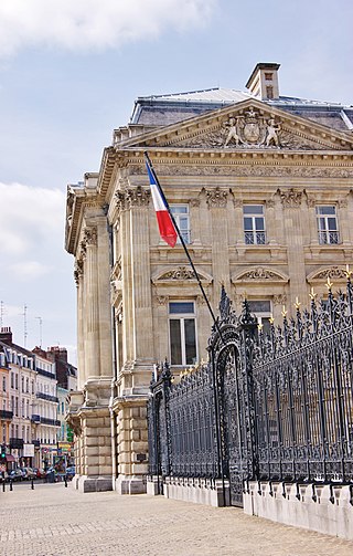
Ardennes is a department in the Grand Est region of northeastern France named after the broader Ardennes. Its prefecture is the town Charleville-Mézières. The department has 270,582 inhabitants. The inhabitants of the department are known as Ardennais or Ardennaises.

<span class="mw-page-title-main">Arques, Pas-de-Calais</span> Commune in Hauts-de-France, France

Arques is a commune in the Pas-de-Calais department in northern France, bordering Saint-Omer.

<span class="mw-page-title-main">Chauny</span> Commune in Hauts-de-France, France

Chauny is a commune in the Aisne department in Hauts-de-France in northern France.

<span class="mw-page-title-main">La Capelle</span> Commune in Hauts-de-France, France

La Capelle is a commune in the Aisne department in Hauts-de-France in northern France. Its inhabitants are called Capellois.

<span class="mw-page-title-main">Auge, Ardennes</span> Commune in Grand Est, France

Auge is a commune in the Ardennes department in the Grand Est region of north-eastern France.

<span class="mw-page-title-main">Aouste</span> Commune in Grand Est, France

Aouste is a commune in the Ardennes department in the Grand Est region of northern France.

<span class="mw-page-title-main">Any-Martin-Rieux</span> Commune in Hauts-de-France, France

Any-Martin-Rieux is a commune in the department of Aisne in the Hauts-de-France region of northern France.

<span class="mw-page-title-main">Les Autels</span> Commune in Hauts-de-France, France

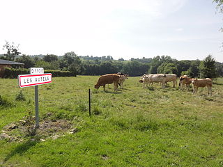
Les Autels is a commune in the department of Aisne in the Hauts-de-France region of northern France.

<span class="mw-page-title-main">Aubenton</span> Commune in Hauts-de-France, France

Aubenton is a commune in the department of Aisne in the Hauts-de-France region of northern France.

<span class="mw-page-title-main">Autreppes</span> Commune in Hauts-de-France, France

Autreppes is a commune in the department of Aisne in the Hauts-de-France region of northern France and in the natural region of Thiérache.

<span class="mw-page-title-main">Brunehamel</span> Commune in Hauts-de-France, France

Brunehamel is a commune in the department of Aisne in Hauts-de-France in northern France.

<span class="mw-page-title-main">Parpeville</span> Commune in Hauts-de-France, France

Parpeville is a commune in the Aisne department in Hauts-de-France in northern France. Situated 24 kilometers east of Saint-Quentin and 28 kilometers northwest of Laon, Parpeville overlooks the surrounding plains due to its varying altitudes, ranging from 79 meters to 144 meters above sea level.

<span class="mw-page-title-main">Chaumont-le-Bois</span> Commune in Bourgogne-Franche-Comté, France

Chaumont-le-Bois is a commune in the Côte-d'Or department in eastern France.

<span class="mw-page-title-main">Buc, Yvelines</span> Commune in Île-de-France, France

Buc is a commune in the Yvelines department and Île-de-France region of north central France.

The canton of Hirson is an administrative division in northern France. At the French canton reorganisation which came into effect in March 2015, the canton was expanded from 13 to 26 communes:

<span class="mw-page-title-main">Florentine tower of Buire</span> Railway tower in Buire, France

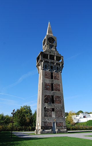
The Florentine Tower of Buire, located in the commune of Buire in the Aisne department in Picardy in northern France, is a former 45.76 meter tallsignal box. Since November 6, 1995, it has been classified as a monument historique. It is the work of French architect Gustave Umbdenstock and the engineer Raoul Dautry employed by the Compagnie des chemins de fer du Nord. The decision to build the tower was made following the development of the railway station of Hirson, which, due to the development of the local mining and metallurgical industry, became the second most important French rail junction in the early twentieth century.

Alfred Desmasures was a French journalist writer essayist and historian, born in Mondrepuis January 20, 1832 and died the May 20, 1893 in Hirson.

<span class="mw-page-title-main">Barisis-aux-Bois</span> Commune in Hauts-de-France, France

Barisis-aux-Bois, formerly called Barisis until 3 December 2014, is a commune in the department of Aisne in the Hauts-de-France region of northern France.

References

  1. "Répertoire national des élus: les maires". data.gouv.fr, Plateforme ouverte des données publiques françaises (in French). 2 December 2020.
  2. "Populations légales 2020". The National Institute of Statistics and Economic Studies. 29 December 2022.
  3. Wikisource-logo.svg One or more of the preceding sentences incorporates text from a publication now in the public domain :  Chisholm, Hugh, ed. (1911). "Hirson". Encyclopædia Britannica . Vol. 13 (11th ed.). Cambridge University Press. p. 525.
  4. Des villages de Cassini aux communes d'aujourd'hui: Commune data sheet Hirson, EHESS (in French).
  5. Population en historique depuis 1968, INSEE