
The Pacific Ocean is the largest and deepest of Earth's oceanic divisions. It extends from the Arctic Ocean in the north to the Southern Ocean in the south and is bounded by Asia and Australia in the west and the Americas in the east.

Tubuai or Tupua'i is the main island of the Tubuai Island group, located at 23°23′00″S149°27′00″W, 640 km (400 mi) south of Tahiti. In addition to Tubuai, the group of islands include Rimatara, Rurutu, Raivavae and the uninhabited Îles Maria. They are part of the Austral Islands in the far southwest of French Polynesia in the south Pacific Ocean. Tubuai island sustains a population of 2,217 people on 45 km² of land. Due to its southerly position, Tubuai has notably cooler weather than Tahiti.

Moruroa, also historically known as Aopuni, is an atoll which forms part of the Tuamotu Archipelago in French Polynesia in the southern Pacific Ocean. It is located about 1,250 kilometres (780 mi) southeast of Tahiti. Administratively Moruroa Atoll is part of the commune of Tureia, which includes the atolls of Tureia, Fangataufa, Tematangi and Vanavana. France undertook nuclear weapon tests between 1966 and 1996 at Moruroa and Fangataufa, causing international protests, notably in 1974 and 1995. The number of tests performed have been variously reported as 175 and 181.

Rikitea is a small town on Mangareva, which is part of the Gambier Islands in French Polynesia. A majority of the islanders live in Rikitea. The island was a protectorate of France in 1871 and was annexed in 1881.

With its 320 square kilometres, Hiva Oa is the second largest island in the Marquesas Islands, in French Polynesia, an overseas territory of France in the Pacific Ocean. Located at 9 45' south latitude and 139 W longitude, it is the largest island of the southern Marquesas group. Around 2,200 people reside on the island. A volcano, Temetiu, is Hiva Oa's highest point with 1,200 metres.

Sliabh Liag, sometimes Slieve League or Slieve Liag, is a mountain on the Atlantic coast of County Donegal, Ireland. At 596 metres (1,955 ft), it has some of the highest sea cliffs on the island of Ireland. Although less famous than the Cliffs of Moher in County Clare, Slieve League's cliffs reach almost three times higher.
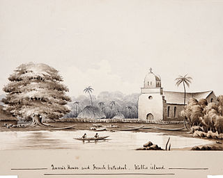
Mata-Utu is the capital of Wallis and Futuna, an overseas collectivity of France. It is located on the island of Uvéa (ʻUvea), in the district of Hahake, of which it is also the capital. Its population is 1,191. It is one of two ports in Wallis and Futuna, the other being at Leava on Futuna. Hihifo Airport, the main airport accessing the island and city, is 5.6 kilometres (3.5 mi) to the northwest.
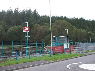
Ynyswen railway station is a railway station serving the village of Ynyswen in Rhondda Cynon Taf, south Wales. It is located on the Rhondda Line.

The Hawaiian Poi Dog is an extinct breed of pariah dog from Hawaiʻi which was used by Native Hawaiians as a spiritual protector of children and as a source of food.
Tautira is a Polynesian beach village, valley, and point on the south-east coast of the island of Tahiti in the Pacific. It is part of the commune Taiarapu-Est. With a population of 2338, it is located 49 kilometres southeast of the Tahitian capital of Papeete on the coast of Tautira Bay, at the end of what is the largest valley of the Taiarapu Peninsula. Domingo de Bonechea visited the area in 1772 and attempted to spread Christianity here; James Cook landed at Tautira Bay during his voyage. Robert Louis Stevenson referred to the village as “The Garden of the World”, staying here to recover from illness in 1886. The village contains a Catholic church.
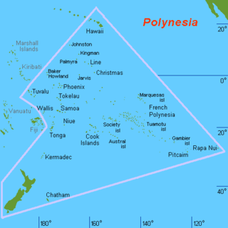
Polynesia is a subregion of Oceania, made up of more than 1,000 islands scattered over the central and southern Pacific Ocean. The indigenous people who inhabit the islands of Polynesia are termed Polynesians, and share many similar traits including language family, culture, and beliefs. Historically, they had a strong tradition of sailing and using stars to navigate at night. The largest country in Polynesia is New Zealand.

Pueu is a village and district on the east coast of Tahiti, 66 km (41 mi) south east of Papeete. It lies northwest by road from Tautira. It lies on a lagoon and contains an old church.It hosts a Spiritual Festival on Christmas Day.The Spaniards named the harbour within the Pueu reef "Puerto de la Virgen".Pueu contains the Te Anuanua Hotel, located to the southeast of the church, with four duplex bungalows. In 1958, 61.6% of the villagers of the district voted for independence.

In 2013, the island country Niue produced 3,200 tonnes of coconuts valued at INT$385,830. Coconut is a cash crop on the island, which is converted to derivatives such as copra and coconut cream in tinned form, and also exported. Originally, the island had a profusion of coconut trees reflected in the country's name, Niue, in the local language. The Niue Development Board is responsible for planning and execution of schemes of agricultural produce, including coconut and related products.

St. Michael's Cathedral, also known as the Rikitea Cathedral, is a parish of the Catholic Church located on Mangareva Island in the Gambier Islands of French Polynesia.

Te Maputeoa was a monarch of the Polynesian island of Mangareva and the other Gambier Islands. He was the King or ʻAkariki, as well as the penultimate king of the island of Mangareva, and other Gambier Islands including Akamaru, Aukena, Taravai and Temoe. He reigned from 1830 until his death in 1857.
Internal Autonomy Day is an official holiday in French Polynesia, an overseas collectivity of France. It is celebrated annually on 29 June, to honor Tahitian and French Polynesian self-rule. The day also marked the annexation of the Kingdom of Tahiti and the turnover of native sovereignty by King Pōmare V to France.

Fagasa is a village in the Eastern District of Tutuila Island in American Samoa. The village lies by Fagasa Bay, on the north shore of the island. Its name is Samoan and translates to “Forbidden Bay.” The village borders the Tutuila-section of National Park of American Samoa. The trailhead to Mount ‘Alava is located near the village by Fagasa Pass.


