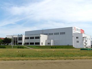
北海道情報大学 | |
Type | Private |
---|---|
Established | 1968 |
Location | Ebetsu , Hokkaidō , Japan |
Website | Official website |
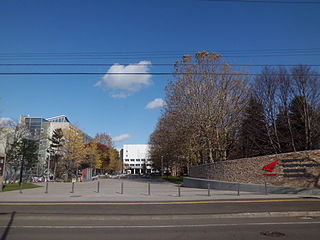
Hokkaido Information University(北海道情報大学 Hokkaidō Jōhō Daigaku) is a private university in Ebetsu, Ishikari Subprefecture, Hokkaidō, Japan.
A public university is a university that is publicly owned or receives significant public funds through a national or subnational government, as opposed to a private university. Whether a national university is considered public varies from one country to another, largely depending on the specific education landscape.
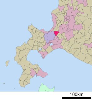
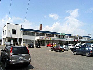
Ebetsu is a city in Ishikari Subprefecture, Hokkaido, Japan.
Ishikari Subprefecture is a subprefecture of Hokkaido Prefecture, Japan, located in the western part of the island. The subprefecture covers 3,539.86 square kilometres (1,366.75 sq mi) and in 2011 had a population of 2,334,241. The subprefecture takes its name from the Ishikari River, the third longest in Japan, which flows through western Hokkaido and empties into the Sea of Japan in the city of Ishikari. There are 6 cities, three towns, and one village under its jurisdiction. Sapporo is both the capital of Hokkaido Prefecture and Ishikari Subprefecture. Shikotsu-Toya National Park is located in the southern part of the subprefecture, and Shokanbetsu-Teuri-Yagishiri Quasi-National Park in the north.
It was initially established in April 1968 with the name Hokkaido Electronics Computer School. Since 1989, Hokkaido Information University became the officially adopted name.
Currently it holds international exchange agreements with Nanjing University, Shenyang Normal University in China; University of California, Santa Cruz in USA; and Rajamangala University of Technology in Thailand.
Nanjing University, known as Nanda, is a major public university, the oldest institution of higher learning in Nanjing, Jiangsu, and a member of the elite C9 League of Chinese universities.
Shenyang Normal University is a broad-based university in Shenyang, Liaoning Province, China under the provincial government.
The University of California, Santa Cruz is a public research university in Santa Cruz, California. It is one of 10 campuses in the University of California system. Located 75 miles (120 km) south of San Francisco at the edge of the coastal community of Santa Cruz, the campus lies on 2,001 acres (810 ha) of rolling, forested hills overlooking the Pacific Ocean and Monterey Bay.
Kita-ku is a ward of Sapporo composed of residential neighborhoods mostly arranged in grid patterns, and each built surrounding a train station, broken up by areas of farmland and some light-industrial areas. With 260,000 people, it is the most populated ward in Sapporo.
Sapporo University, also known as 札大 (Satsu-dai) for an abbreviation, is a private university in Sapporo, Japan. It was founded in 1967.
Atsubetsu-ku (厚別区) is one of the ten wards in Sapporo city, Japan. The ward was split from Shiroishi-ku on November 6, 1989.
Chūō-ku is one of the ten wards in Sapporo, Hokkaido, Japan. Chūō-ku means "central ward" in Japanese. As its name suggests, city administration and entertainment facilities are centred in this ward.
Iwamizawa Station is a railway station in Iwamizawa, Hokkaido, Japan, operated by the Hokkaido Railway Company. The station is numbered A13.
Takikawa Station is a railway station in Takikawa, Hokkaido, Japan, operated by the Hokkaido Railway Company.
Ōdōri Station is a subway station in Chūō-ku, Sapporo, Hokkaido, Japan, operated by Sapporo Municipal Subway. The station opened on December 16, 1971 as part of the first phase of the Namboku Line.
Teine-ku (手稲区) is one of the 10 wards in Sapporo, Hokkaidō, Japan. The ward is located in northwest of Sapporo, which is neighboured to three other wards in Sapporo and two cities. The area was established as one of the wards in Sapporo in 1989, when it was split from Nishi-ku, Sapporo.
Hokkaido University of Science, or HUS, is a private university in Sapporo, Hokkaidō, Japan, established in 1967. The predecessor of the school was founded in 1924.
The Health Sciences University of Hokkaido (HSUH) is a private university in Tobetsu, Hokkaido, Japan, established in 1974. The president is Norio Niikawa.
Hokusho University is a private university in Ebetsu, Hokkaido, Japan. The predecessor of the school was founded in 1939 under the name Hokkaido Women's College. It was chartered as a junior women's college in 1963. It became a four-year college in 1997. The present name was adopted in 2007.
Shinrin-Kōen Station is a railway station on the Hakodate Main Line in Atsubetsu-ku, Sapporo, Hokkaido, Japan, operated by Hokkaido Railway Company. The station is numbered "A05".
Shin-Kotoni Station is a railway station on the Sasshō Line in Kita-ku, Sapporo, Hokkaido, Japan, operated by the Hokkaido Railway Company. The station is numbered G05.
Ainosato-Kyōikudai Station is a railway station on the Sasshō Line in Kita-ku, Sapporo, Hokkaido, Japan, operated by the Hokkaido Railway Company. The station is numbered G10.
Ishikari-Tōbetsu Station is a railway station on the Sasshō Line in Tōbetsu, Hokkaidō, Japan, operated by the Hokkaido Railway Company. The station is numbered G13.
Hokkaidō-Iryōdaigaku Station is a railway station on the Sasshō Line in Tōbetsu, Hokkaidō, Japan, operated by the Hokkaido Railway Company. The station is numbered G14.
Sapporo Station is a Sapporo Municipal Subway station in Chūō-ku, Sapporo, Hokkaido, Japan. The station is numbered "N06" for the Namboku Line, and "H07" for the Tōhō Line. The station is connected to the JR Hokkaido Sapporo Station by an underground passage.
Hokkaido Korean Primary, Middle and High School or the Hokkaido Corean School is a North Korean elementary, junior high, and senior high school in Kiyota-ku, Sapporo, Hokkaido.
Shin Nihonkai Ferry Co., Ltd. is a marine transportation company based in Japan.
Coordinates: 43°4′40.1″N141°32′13.8″E / 43.077806°N 141.537167°E
A geographic coordinate system is a coordinate system that enables every location on Earth to be specified by a set of numbers, letters or symbols. The coordinates are often chosen such that one of the numbers represents a vertical position and two or three of the numbers represent a horizontal position; alternatively, a geographic position may be expressed in a combined three-dimensional Cartesian vector. A common choice of coordinates is latitude, longitude and elevation. To specify a location on a plane requires a map projection.
This article on a Hokkaidō institute of higher education or related topic is a stub. You can help Wikipedia by expanding it. |