
The geography of Mozambique consists mostly of coastal lowlands with uplands in its center and high plateaus in the northwest. There are also mountains in the western portion. The country is located on the east coast of southern Africa, directly west of the island of Madagascar. Mozambique has a tropical climate with two seasons, a wet season from October to March and a dry season from April to September.

Zimbabwe is a landlocked country in southern Africa lying wholly within the tropics. It straddles an extensive high inland plateau that drops northwards to the Zambezi valley where the border with Zambia is and similarly drops southwards to the Limpopo valley and the border with South Africa. The country has borders with Botswana 813 km, Mozambique 1,231 km, South Africa 225 km, Zambia 797 km and almost meets Namibia at its westernmost point.

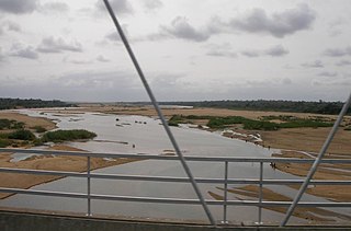
The Zambezi River is the fourth-longest river in Africa, the longest east-flowing river in Africa and the largest flowing into the Indian Ocean from Africa. The area of its basin is 1,390,000 square kilometres (540,000 sq mi), slightly less than half of the Nile's. The 2,574-kilometre-long river (1,599 mi) rises in Zambia and flows through eastern Angola, along the north-eastern border of Namibia and the northern border of Botswana, then along the border between Zambia and Zimbabwe to Mozambique, where it crosses the country to empty into the Indian Ocean.
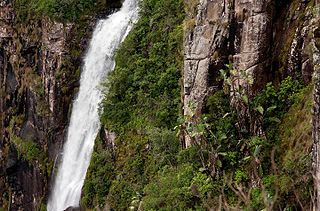
Mutarazi Falls is a waterfall in Mutasa District in Manicaland Province, Zimbabwe. it is located in the 2,495 hectare Mutarazi National Park adjacent to the southern border of the Nyanga National Park. At 772 meters (2,533 ft), it is the highest in Zimbabwe, second highest in Africa and 17th highest in the World.
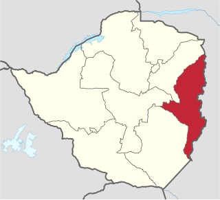
Manicaland is a province in eastern Zimbabwe. After Harare Province, it is the country's second-most populous province, with a population of 1.75 million, as of the 2012 census. After Harare and Bulawayo provinces, it is Zimbabwe's third-most densely populated province. Manicaland was one of five original provinces established in Southern Rhodesia in the early colonial period. The province is divided into ten administrative subdivisions of seven rural districts and three towns/councils, including the provincial capital, Mutare. The name Manicaland is derived from one of the province's largest ethnic groups, the Manyika, who originate from the area north of the Manicaland province and as well as western Mozambique, who speak a distinct language called chiManyika.

Gaza is a province of Mozambique. It has an area of 75,709 km2 and a population of 1,422,460, which is the least populous of all the provinces of Mozambique.

Nyanga is a town in Zimbabwe. At one time, the town was known as Inyanga.

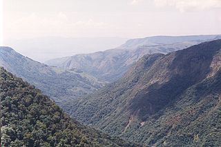
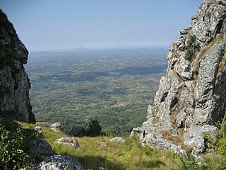
The Eastern Highlands, also known as the Manica Highlands, is a mountain range on the border of Zimbabwe and Mozambique. The Eastern Highlands extend north and south for about 300 kilometres (190 mi) through Zimbabwe's Manicaland Province and Mozambique's Manica Province.

The Honde Valley extends from the eastern border of Zimbabwe into Mozambique. The valley is part of the Eastern Highlands. The valley is about 130 kilometres from Mutare, or 110 kilometres from Nyanga. The Nyanga Mountains and the Nyanga National Park forms the western boundary of the valley.

Nyanga National Park lies in the north of Zimbabwe's Eastern Highlands. One of the first national parks to be declared in the country, it contains the highest land in Zimbabwe, with green hills and perennial rivers. Most of its terrain consists of rolling downland, sometimes lightly wooded, lying at altitudes between 1,800–2,593 metres. Mount Nyangani, the highest point in Zimbabwe, lies in the centre of the park and Mutarazi Falls, Zimbabwe's highest waterfall, is in the south of the park. Nyanga National park incorporates the former Mutarazi Falls National Park on its southern boundary.
The Save River, or Sabi River is a 400 mi (640 km) river of southeastern Africa, flowing through Zimbabwe and Mozambique. The river has its source in Zimbabwe, some 80 km (50 mi) south of Harare, then flows south and then east, from the Zimbabwean highveld to its confluence with the Odzi River. It then turns south, drops over the Chivirira Falls, and flows down the western side of Zimbabwe's Eastern Highlands forming a dry river valley in the rain shadow of these mountains. It is joined by the Runde River or Lundi at the Mozambique border, forming a dramatic confluence at Mahenya. It then crosses Mozambique to flow into the Indian Ocean at about 21°S.
Hauna is a village in the province of Manicaland, Zimbabwe located in the Honde Valley communal land about 55 km north of Mutare.It is the Growth Point Centre for Mutasa District in Manicaland. Hauna growth point is in Samanga B ward of Mutasa District and has a population of about 8,000. There is an aerodrome where small aeroplanes can land and take off. There is also a Police camp called Ruda Police Station which controls all police activities in Mutasa District.

Mount Nyangani is the highest mountain in Zimbabwe at 2,592 m (8,504 ft). The mountain is located within Nyanga National Park in Nyanga District, is about 110 km (68 mi) North West Mutare. The summit lies atop a small outcrop of rock around 40m above the surrounding area. The remainder of the peak is a broad moor of mainly rolling hills and plateau with an area of about 8 km2. The edges of this plateau then fall steeply to the east and west sides. The mountain vegetation is largely composed of heath around the summit plateau with evergreen forest along the wetter eastern slopes and grassland to the western side. Annual rainfall totals are high but long spells of dry weather occur during the winter period of May to August. Due to its relatively low altitude and tropical location, snow falls very rarely, last recorded in August 1935.
Pungwe River is a 400 km (250 mi) long river in Zimbabwe and Mozambique. It rises below Mount Nyangani in the Eastern Highlands of Zimbabwe and then flows southeasteastward through the Manica and Sofala provinces of Mozambique. the Pungwe enters the Urema Valley, the southernmost portion of the Great Rift Valley, where it forms the southern boundary of Gorongosa National Park. The Urema River joins it, and the river follows the rift valley southward. Large seasonal wetlands form around the Pungwe and Urema rivers in the rift valley section. It empties into the Mozambique Channel at Beira, forming a large estuary. It is one of the major rivers of Mozambique and often causes floods.

Buzi River is a river in Mozambique. The Buzi River originates in the Eastern Highlands on the border of Mozambique and Zimbabwe, and flows eastward through Manica and Sofala provinces of Mozambique. It empties to the Mozambique Channel west of Beira, forming a large estuary with the Pungwe River.

Mwenezi River is a major tributary of the Limpopo River. The Mwenezi River starts up in south central Zimbabwe and flows south-east along what is known as the Mwenezi River Valley that bisects the district into two sectors. The river is found in both Zimbabwe and Mozambique. In Zimbabwe it has been known as the Nuanetsi or Nuanetzi River in the past, a name it retains in Mozambique.
Mutasa District is one of seven districts in Manicaland Province of Zimbabwe. Mutasa District is located 30 km northeast Mutare and stretches up to the Honde Valley, which is about 100 km northeast of Mutare along a tarred road that branches off the Nyanga road.

Nyanga District is located in Manicaland Province of Zimbabwe.
The Choa Mountains are a mountain range in Manica Province of Mozambique. The mountains lie in Báruè District, west of Catandica.
The Urema Valley, also known as the Urema Graben, is a lowland valley in Sofala Province of central Mozambique.
