
Barren Island is one of the Falkland Islands, lying south west of East Falkland and south east of George Island. It is separated from Lafonia by Eagle Passage. Its total area is 11.5 square kilometres (4.4 sq mi).
George Island is the second largest of the Speedwell Island Group in the Falkland Islands with a land area of 24 square kilometres (9.3 sq mi). It lies south of Speedwell Island and south west of East Falkland, and is separated from Lafonia by Eagle Passage. The island is generally flat, rising no more than 18 metres (59 ft) above sea level, and there are several ponds and there is severe soil erosion in the central section. However, the island is free of rats.

The Falkland Sound is a sea strait in the Falkland Islands. Running southwest-northeast, it separates West and East Falkland.

San Carlos is a settlement in northwestern East Falkland, lying south of Port San Carlos on San Carlos Water. It is sometimes nicknamed "JB" after a former owner, Jack Bonner. The settlement consists of a number of properties including a dwelling with a small cafe which also provides craft facilities. As noted in the history section, there is a small museum that pays homage to the Falklands Conflict as well as local nature and culture.

The Camp is the term used in the Falkland Islands to refer to any part of the islands outside the islands' only significant town, Stanley, and often the large RAF base at Mount Pleasant. It is derived from the Spanish word campo, for "countryside".

The Bodie Creek Suspension Bridge in the Falkland Islands is said to be the southernmost suspension bridge in the world. It was built in 1925, from a kit fabricated in England by David Rowell & Co., in order to shorten the distance sheep needed to be driven from southern Lafonia to the shearing sheds in Goose Green.
North Arm is a settlement in Lafonia, the southern part of East Falkland, in the Falkland Islands, It is on the south coast, on the shore of the Bay of Harbours, and overlooks Sea Lion Island in the distance. In 2007, the population was 25 people, six of them children. It is the largest settlement on East Falkland south of Goose Green. North Arm is 90 miles (140 km) from Stanley, and it takes four and a half hours to drive there.
The Wickham Heights are a rugged chain of mountains on East Falkland in the Falkland Islands. They include the island group's highest peak, Mount Usborne, Mount Wickham and are partly contiguous with No Man's Land. The slopes of Wickham Heights feature numerous stone runs, some of them extending up to 5 km.

Choiseul Sound is a stretch of sea in the Falkland Islands. It runs parallel to Eagle Passage and is between Lafonia and the north of East Falkland. Lively Island is in its mouth. At its entrance, on the northern shore, is the Bertha's Beach Important Bird Area which is also a Ramsar site, recognising it as a wetland of international importance.

The Tyssen Islands lie in Falkland Sound, between West Falkland and East Falkland. They lie off Lafonia in East Falkland, and between the Swan Islands and Great Island, Falkland Islands.

Brenton Loch is an inlet-cum-small fjord in the Falkland Islands. It is one of a handful of sea lochs outside Scotland. It is sometimes known as "Brenton Sound". "Loch" is normally pronounced as "lock" in the English rather than Scottish manner, i.e. without a fricative "ch". The far south of the loch is known as "La Boca" or "The Boca".
Walker Creek is a settlement on East Falkland, in the Falkland Islands, in Lafonia. It is on the shore of the Choiseul Sound, and overlooks Sea Lion Island in the distance. It is the second largest settlement on East Falkland south of Goose Green, after North Arm.
Bull Point is the most southerly part of East Falkland, and of the two main islands of the Falklands. It is at the far end of Lafonia, near Eagle Passage, and forms part of the west shore of the Bay of Harbours. A 1500 ha tract has been identified by BirdLife International as an Important Bird Area (IBA).

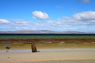
The Bay of Harbours is a bay/fjord on the south east coast of East Falkland. It is in Lafonia between Eagle Passage and the Adventure Sound, and forms the lower segment of the "E" of the peninsula. North Arm is at its landward end.
Eagle Passage is a strait in the Falkland Islands, between Lafonia in the southwest of East Falkland, and the smaller islands of Speedwell, Barren and George Island. George Island and Speedwell Island form the stretch of land to the south of the passage while East Falkland forms the northern stretch. The passage is difficult to navigate as ships may founder on the reefs and kelp lying off the surrounding islands.
Egg Harbour is a location in Lafonia on East Falkland. It faces onto Falkland Sound. There are a few buildings here, some of them abandoned.

Race Point is the point on the north side of Smylie Channel forming the south extremity of Weddell Island in the Falkland Islands. The point is located at 51°59′22″S61°00′00″W, which is 26.7 km south-southwest of Swan Point, 3.5 km west-northwest of neighbouring Dyke Island, 1.8 km north of West Island and 4 km north-northeast of Orford Hill, West Falkland.
Smylie Channel is the 1.4 kilometres (0.76 nmi) wide and 16 kilometres (8.6 nmi) long sea passage in the Falkland Islands between Weddell Island to the north and West Falkland and Dyke Island to the south. It is centred at 51°59′04″S61°03′48″W.


