Tallangatta is a town in north-eastern Victoria, Australia. The town lies on the banks of the Mitta Arm of Lake Hume, approximately 38 kilometres (24 mi) south-east of Albury-Wodonga along the Murray Valley Highway. At the 2016 census, Tallangatta had a population of 1,082.

Wangaratta is a city in the northeast of Victoria, Australia, 236 km (147 mi) from Melbourne along the Hume Highway. The city had an estimated urban population of 19,318 at June 2018. Wangaratta has recorded a population growth rate of almost 1% annually since 2016 to 2018 which is the second highest of all cities in North-Eastern Victoria.

The Shire of Yarriambiack is a local government area of Victoria, Australia, located in the north-western part of the state. It covers an area of 7,326 square kilometres (2,829 sq mi) and, in June 2018, had a population of 6,658, having fallen from 7,438 in 2008. It includes the towns of Hopetoun, Murtoa, Rupanyup and Warracknabeal. It was formed in 1995 from the amalgamation of the Shire of Warracknabeal, Shire of Karkarooc, and parts of the Shire of Dunmunkle and Shire of Wimmera.

Terang is a town in the Western District of Victoria, Australia. The town is in the Shire of Corangamite and on the Princes Highway 212 kilometres (132 mi) south west of the state's capital, Melbourne. At the 2006 census, Terang had a population of 1,824. At the 2001 census, Terang had a population of 1,859. The population of Terang has since risen according to the 2011 Census; the population is now 2,348, of which 1,155 are male and 1,193 are female, with the median age being 44.
Rainbow is a town in the Shire of Hindmarsh in northwest Victoria, Australia, 400 kilometres (250 mi) from Melbourne. The nearest large towns are Warracknabeal, Dimboola and Nhill, all to the south. At the 2016 census, Rainbow had a population of 683.

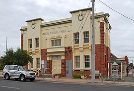
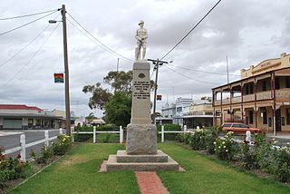
Warracknabeal is a wheatbelt town in the Australian state of Victoria. Situated on the banks of the Yarriambiack Creek, 330 km north-west of Melbourne, it is the business and services centre of the northern Wimmera and southern Mallee districts, and hosts local government offices of the Shire of Yarriambiack. At the 2011 census Warracknabeal district had a population of 2,745, of which 2,340 lived in the town.

Charlton is a town in Victoria, Australia. It is a small agricultural community straddling the Avoca River, located at the junction of the Calder Highway (A79) and Borung Highway (C239) and positioned in the last of the foothills of the Great Dividing Range. Halfway between Melbourne and Mildura, Charlton is a popular tourist stop.

Kyabram is a large town in north central Victoria, Australia. Kyabram is located in the centre of a rich irrigation district in the Goulburn River Valley, 200 kilometres (120 mi) north of Melbourne. It is the second-largest town in the Shire of Campaspe, situated between the towns of Echuca and Shepparton and is close to the Murray River, Goulburn River, Campaspe River and Waranga Basin. As of the 2011 census the town had a population of 7,321 people and provides services to a district population of around 16,000.
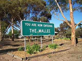
The Mallee is an ill-defined district, sometimes incorrectly referred to as an economic region, of the Australian state of Victoria. The district is located entirely within the Loddon Mallee region; and covers the most northwesterly district in the state bounded by the South Australian and New South Wales borders, inclusive of the Murray River.

Wallan, traditionally known as Wallan Wallan, is a town in Victoria, 45 kilometres (28 mi) north of Melbourne's Central Business District. The town sits at the southern end of the large and diverse Shire of Mitchell which extends from the northern fringes of Melbourne into the farming country of north-central Victoria and the lower Goulburn Valley. The township flanks the Northern Highway and is set against the backdrop of the Great Dividing Range. At the 2016 census, Wallan had a population of 8,520.

Underbool is a town in the Mallee region of north-west Victoria, Australia. The town is in the Rural City of Mildura local government area and on the Mallee Highway—between Ouyen and the South Australian border – 476 kilometres (296 mi) north west of the state capital, Melbourne. At the 2006 census, Underbool had a population of 217. The town services the grain farmers and graziers in the area. For tourists it provides access to the Pink Lakes in Murray-Sunset National Park.

Birchip is a town in the Mallee region of Victoria, Australia on the Sunraysia Highway north of Donald. The town is located in the Shire of Buloke local government area. At the 2016 census, Birchip had a population of 702, up from the 2011 figure of 662. It has a P-12 school, and an Australian rules football club called Birchip-Watchem, also known as the Birchip-Watchem Bulls, or just the "Bulls".
Dunkeld is a town in Victoria, Australia, at the southern end of the Grampians National Park, in the Shire of Southern Grampians. It is approx 283 km west of Melbourne on the Glenelg Highway. The town's population is holding steady but ageing. At the 2016 census, Dunkeld had a population of 678.

Kilcoy is a town and locality in the Somerset Region local government area in South East Queensland, Australia.

Newborough is a town in the Latrobe Valley in Victoria, Australia which shares a border to its west, mostly along the Narracan Creek, with the town of Moe. It can be divided into three areas, Old Newborough, East Newborough and North Newborough. The latter two areas were developed by the State Electricity Commission of Victoria in the 1950s as residential housing for workers at the nearby Yallourn coal mining, power generation and briquette making works. Newborough now has a higher than average proportion of retirees and aged residents, and it has been suggested that it owes its generally quiet character to this fact. At the 2016 census, Newborough had a population of 6,763.

Minyip is a town in the Wimmera region of Victoria, Australia, 320 kilometres (199 mi) north west of Melbourne. It is in the Shire of Yarriambiack local government area. At the 2016 census, Minyip had a population of 524.

Woomelang is a town in the Mallee region of Victoria, Australia. The town is in the Shire of Yarriambiack local government area and on the Sunraysia Highway, 359 kilometres (223 mi) north-west of the state capital, Melbourne, 183 kilometres (114 mi) south-east of Mildura and 154 kilometres (96 mi) north of Horsham. At the 2011 census, Woomelang and the surrounding area had a population of 191.

Rupanyup is a small town in rural Victoria, Australia. As of the 2016 census, it had a population of 536. The name Rupanyup is an Aboriginal word meaning 'branch hanging over water'.

Beulah is a town in the southern Mallee region of Victoria, Australia. The town is in the Shire of Yarriambiack local government area, 395 kilometres north-west of the state capital, Melbourne. At the 2016 census, Beulah had a population of 329.

Brim is a small town in the Wimmera region of Victoria, Australia. The town is located 359 kilometres (223 mi) north west of the state capital, Melbourne on the Henty Highway. It is on the banks of the Yarriambiack Creek. It is in the Shire of Yarriambiack local government area. At the 2016 census, Brim had a population of 171.