
Olot is the capital city of the comarca of Garrotxa, in the Province of Girona, Catalonia, Spain. The city is known for its natural landscape, including four volcanoes scattered around the city center. The municipality is part of the Garrotxa Volcanic Zone Natural Park. Olot is also well known for its cultural activity, with historical art movements like Olot school or factories of religious imagery, which contributed to the location in the city of the main Design and Arts & Crafts school of the province of Girona, the Escola d'Art i Superior de Disseny d'Olot.

In Spain traditionally and historically, some autonomous communities are also divided into comarcas.
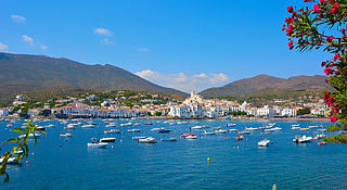
Cadaqués is a town in the Alt Empordà comarca, in the province of Girona, Catalonia, Spain. It is on a bay in the middle of the Cap de Creus peninsula, near Cap de Creus cape, on the Costa Brava of the Mediterranean. It is two-and-a-quarter-hour drive from Barcelona, and thus it is accessible not only to tourists but also to people who want a second home for weekends and summers. In 2002, Cadaqués had an official population of 2,612, but up to ten times as many people can live in the town during the peak of the summer tourism season.

Garrotxa is a comarca (county) in Girona, Catalonia, Spain. Its population in 2016 was 55,999, more than half of them in the capital city of Olot. It is roughly equivalent to the historical County of Besalú.

Matarraña or Matarranya is a comarca in eastern Aragon, bordering the Spanish Autonomous Communities of Catalonia and Valencia. It is located in Teruel Province, in the mountainous Sistema Ibérico area.
El Vendrell is a town located in the province of Tarragona, Catalonia, in the wine-growing region of Penedès. It is wedged between the Mediterranean and the coastal range. El Vendrell is the capital of the Baix Penedès comarca and a tourist spot, with the beaches of Comarruga, Sant Salvador and El Vendrell.

Sant Andreu de Llavaneres is a municipality located 36 km north of Barcelona (Catalonia) (Spain), along the Mediterranean coast, between Mataró and Sant Vicenç de Montalt. It belongs to the Maresme comarca and the Barcelona province. The short name is simply Llavaneres.
Montcada i Reixac, often referred to as simply Montcada, is a municipality in the comarca of the Vallès Occidental in Catalonia, Spain. It is situated at the confluence of the Ripoll river and the Besós river, and very close to the northernmost neighbourhoods of the city of Barcelona and is therefore a part of the metropolitan area of Barcelona. It had 33,656 inhabitants according to the 2010 census.

Argentona is a municipality in the comarca of the Maresme in Catalonia, Spain. It is situated on the south-east side of the granite Litoral range, to the north-west of Mataró. The town is both a tourist centre and a notable horticultural centre. A local road links the municipality with Cabrera de Mar and with the main N-II road at Vilassar de Mar.

Dosrius is a municipality in the comarca of Maresme in Catalonia, Spain, located in the interior of the comarca on the border with the Eastern Valleys, and is at the head of the Argentona Riera. The original name, first recorded in 963, is "Duos Rios". This literally means "Two Rivers" and refers to the 2 rivers that join to form the Argentona Riera, and is reflected in the coat of arms. These rivers are rarely flowing, though quickly fill during wet weather causing disruption in the village owing to the narrow streets being one way. Newer housing and the school are on the other side of the river, and egress from housing further up the valley frequently takes this route owing to the poor condition of the newly built "Ronda de Dalt". A bridge has been built that would alleviate this problem, though this still hasn't been opened due to the currently suspended construction work that is part of the same development. It is unknown when the bridge will be open to traffic.

Arens de Lledó or Arenys de Lledó is a municipality located in the Matarraña/Matarranya comarca, province of Teruel, Aragon, Spain. According to the 2008 census (INE), the municipality has a population of 217 inhabitants, and covers an area of 34.27 square kilometres. It is situated in the Franja de Ponent.

Sant Fruitós de Bages is a municipality in the comarca of Bages in Catalonia, Spain. The monastery of Sant Benet de Bages is situated here.

Ports de Tortosa-Beseit, also known as Ports de Beseit, or simply as Els Ports[əls ˈpɔɾts] or Lo Port[lu ˈpɔɾt] by locals, is a limestone mountain massif located at the north-eastern end of the Sistema Ibérico, a complex system of mountain ranges and massifs in the centre of the Iberian Peninsula. Its highest point is Mont Caro, 1,441 m. Rivers such as the Matarranya and the Sénia have their source in these mountains.
Sant Joan les Fonts is a municipality of the comarca of Garrotxa, located in Girona, Catalonia, northern Spain. As of 2014, the population is 2,919. Until 1949 it was known as Begudà.

Arnes is a municipality in the comarca of la Terra Alta in Catalonia, Spain.

El Pinell de Brai is a municipality in the comarca of la Terra Alta in Catalonia, Europe.

Roques de Benet is a compact group of sheer rocky outcrops in the northwestern side of the Ports de Tortosa-Beseit, Catalonia, Spain. The highest summit has an elevation of 1,017.1 metres above sea level.

Marçà is a municipality in the comarca of Priorat, Tarragona Province, Catalonia, Spain.

La Vall de Bianya is a municipality of the comarca of Garrotxa, Catalonia, Spain. It is formed by eleven villages scattered around the Bianya and Bac valleys. The seat of the municipal government is in L'Hostalnou de Bianya, and the village with more inhabitants is La Canya. This latter village is divided between the municipalities of La Vall de Bianya and Sant Joan les Fonts. The municipality is part of the Garrotxa Volcanic Zone Natural Park and the Alta Garrotxa Consortium.

Brick Factory at Tortosa is a 1909 oil on canvas painting by Pablo Picasso, which he created during a visit to Horta de Sant Joan in Catalonia. It depicts a landscape of a factory and palm trees, which are presented in a simplified, geometric style. The work belongs to Picasso's African Period and is considered a Proto-Cubist work. It is held in the collection of The State Hermitage Museum in Saint Petersburg.


