Look up hove in Wiktionary, the free dictionary.
Hove is a constituent part of the City of Brighton & Hove in East Sussex, England. It may also refer to:
Hove is a constituent part of the City of Brighton & Hove in East Sussex, England. It may also refer to:

Kemp Town Estate, also known as Kemp Town, is a 19th-century Regency architecture residential estate in the east of Brighton in East Sussex, England, UK. It consists of Arundel Terrace, Lewes Crescent, Sussex Square, Chichester Terrace, and the Kemp Town Enclosures. The estate was conceived and financed by Thomas Read Kemp, designed by Charles Busby and Amon Henry Wilds, and constructed by Thomas Cubitt. Work began in 1823 and it was completed in 1855. It has given its name to the larger Kemptown region of Brighton.

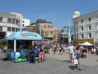
Brighton is a seaside resort and one of the two main areas of the city of Brighton and Hove in the county of East Sussex, England. It is located 47 mi (76 km) south of London. Archaeological evidence of settlement in the area dates back to the Bronze Age, Roman and Anglo-Saxon periods. The ancient settlement of "Brighthelmstone" was documented in the Domesday Book (1086). The town's importance grew in the Middle Ages as the Old Town developed, but it languished in the early modern period, affected by foreign attacks, storms, a suffering economy and a declining population. Brighton began to attract more visitors following improved road transport to London and becoming a boarding point for boats travelling to France. The town also developed in popularity as a health resort for sea bathing as a purported cure for illnesses.

Hove is a seaside resort. It is one of the two main parts of the city of Brighton and Hove, in East Sussex, England.
Brighton and Hove is a city with unitary authority status in East Sussex, England. There are multiple villages alongside the seaside resorts of Brighton and Hove in the district. It is administered by Brighton and Hove City Council, which is currently in Labour majority control.
Brighton is a seaside resort and part of the city of Brighton and Hove.

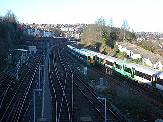
Preston Park railway station is on the Brighton Main Line in England, serving Preston Village and the northern suburban areas of the city of Brighton and Hove, East Sussex. It is 49 miles 21 chains (79.3 km) down the line from London Bridge via Redhill and is situated between Hassocks and Brighton.

Preston or Preston Village is a suburb of the unparished area of Brighton and Hove, in the ceremonial county of East Sussex, England. It is to the north of the centre. Originally a village in its own right, it was eventually absorbed into Brighton with the development of the farmland owned by the local Stanford family, officially becoming a parish of the town in 1928. Stanford-owned land to the south of Preston Manor was given to the town and now makes up Preston Park, one of the largest parks in the now conjoined city of Brighton and Hove. The park hosts some of the city's major public events such as Brighton Pride.

Portslade railway station is a railway station located in Portslade-by-Sea in the city of Brighton and Hove, East Sussex, England, but located on the western fringes of the village of Aldrington. It is 2 miles 73 chains (4.7 km) down the line from Brighton.

Moulsecoomb is a suburb of Brighton, Sussex, England, on the northeast side around the A270 Lewes Road, between Coldean and Bevendean, 2+1⁄4 miles (3.6 km) north of the seafront. The eastern edge adjoins Falmer Hill on the South Downs. It is often divided into smaller sections on maps: North Moulsecoomb, East Moulsecoomb and South Moulsecoomb.

Hangleton is a residential suburb of Hove, in the unparished area of Hove, in the Brighton and Hove district, in the ceremonial county of East Sussex, England. The area was developed in the 1930s after it was incorporated into the borough of Hove, but has ancient origins: its parish church was founded in the 11th century and retains 12th-century fabric, and the medieval manor house is Hove's oldest secular building. The village became depopulated in the medieval era and the church fell into ruins, and the population in the isolated hilltop parish only reached 100 in the early 20th century; but rapid 20th-century development resulted in more than 6,000 people living in Hangleton in 1951 and over 9,000 in 1961. By 2013 the population exceeded 14,000.
Public transport in Brighton and Hove, a city on the south coast of England, dates back to 1840. Brighton and Hove has a major railway station, an extensive bus service, many taxis, coach services, and it has previously had trolley buses, ferries, trams, auto rickshaws and hydrofoils.

Holland Road Baptist Church is a Baptist church in Hove, part of the English city of Brighton and Hove. Built in 1887 to replace a temporary building on the same site, which had in turn superseded the congregation's previous meeting place in a nearby gymnasium, it expanded to take in nearby buildings and is a landmark on Holland Road, a main north–south route in Hove. It is one of ten extant Baptist church buildings in the city, and is the only one to have been listed by English Heritage in view of its architectural importance.

Westdene is an area of the city of Brighton and Hove, East Sussex. It is an affluent northern suburb of the city, west of Patcham, the A23 and the London to Brighton railway line, north of Withdean and northeast of West Blatchington. It is on the Brighton side of the historic parish boundary between Brighton and Hove and is served by Preston Park railway station. It is known for its greenery and woodland and is very close to the South Downs, from which it is separated by the Brighton Bypass, and was built on the slopes of two hills.

Brighton and Hove, a city on the English Channel coast in southeast England, has a large and diverse stock of buildings "unrivalled architecturally" among the country's seaside resorts. The urban area, designated a city in 2000, is made up of the formerly separate towns of Brighton and Hove, nearby villages such as Portslade, Patcham and Rottingdean, and 20th-century estates such as Moulsecoomb and Mile Oak. The conurbation was first united in 1997 as a unitary authority and has a population of about 253,000. About half of the 20,430-acre (8,270 ha) geographical area is classed as built up.
Palmeira Square is a mid-19th-century residential development in Hove, part of the English city and seaside resort of Brighton and Hove. At the southern end it adjoins Adelaide Crescent, another architectural set-piece which leads down to the seafront; large terraced houses occupy its west and east sides, separated by a public garden; and at the north end is one of Hove's main road junctions. This is also called Palmeira Square, and its north side is lined with late 19th-century terraced mansions. Commercial buildings and a church also stand on the main road, which is served by many buses.
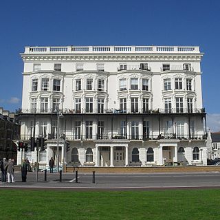
Adelaide Mansions is a residential building on the seafront in Hove, part of the city of Brighton and Hove in East Sussex, England. The "handsome block", decorated with ornate details, was erected in 1873 to the design of local architect Thomas Lainson. English Heritage has listed the building at Grade II for its architectural and historical importance.

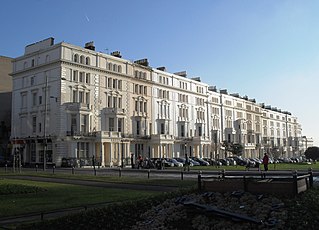
Adelaide Crescent is a mid-19th-century residential development in Hove, part of the English city and seaside resort of Brighton and Hove. Conceived as an ambitious attempt to rival the large, high-class Kemp Town estate east of Brighton, the crescent was not built to its original plan because time and money were insufficient. Nevertheless, together with its northerly neighbour Palmeira Square, it forms one of Hove's most important architectural set-pieces. Building work started in 1830 to the design of Decimus Burton. The adjacent land was originally occupied by "the world's largest conservatory", the Anthaeum; its collapse stopped construction of the crescent, which did not resume until the 1850s. The original design was modified and the crescent was eventually finished in the mid-1860s. Together with the Kemp Town and Brunswick Town estates, the crescent is one of the foremost pre-Victorian residential developments in the Brighton area: it has been claimed that "outside Bath, [they] have no superior in England". The buildings in the main part of Adelaide Crescent are Grade II* listed. Some of the associated buildings at the sea-facing south end are listed at the lower Grade II.

Prestonville is a largely residential area in the northwest of Brighton, part of the English city of Brighton and Hove. It covers a long, narrow and steeply sloping ridge of land between the Brighton Main Line and Dyke Road, two major transport corridors which run north-northwestwards from the centre of Brighton. Residential development started in the 1860s and spread northwards, further from central Brighton, over the next six decades. The area is characterised by middle-class and upper-middle-class housing in various styles, small-scale commercial development and long eastward views across the city. Two Anglican churches serve Prestonville—one at each end of the area—and there are several listed buildings.

Brighton and Hove, a city and unitary authority in the English county of East Sussex, has a wide range of public services funded by national government, East Sussex County Council, Brighton and Hove City Council and other public-sector bodies. Revenue to fund these services comes partly from Council Tax, which is paid annually by residents: this tax provides the city council with nearly 20% of its income and also helps to fund the local police force, Sussex Police, and the county's fire service, East Sussex Fire and Rescue Service. Some of Brighton and Hove's utilities and infrastructure are provided by outside parties, such as utility companies, rather than by the city council.