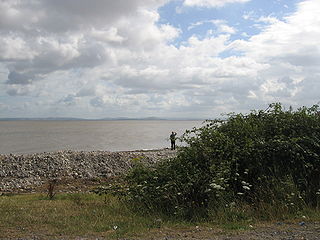
Bridgwater Bay is on the Bristol Channel, 5 kilometres (3.1 mi) north of Bridgwater in Somerset, England at the mouth of the River Parrett and the end of the River Parrett Trail. It stretches from Minehead at the southwestern end of the bay to Brean Down in the north. The area consists of large areas of mudflats, saltmarsh, sandflats and shingle ridges, some of which are vegetated. It has been designated as a Site of Special Scientific Interest (SSSI) covering an area of 3,574.1 hectares since 1989, and is designated as a wetland of international importance under the Ramsar Convention. The risks to wildlife are highlighted in the local Oil Spill Contingency Plan.
The River Yar on the Isle of Wight, England, rises near the beach at Freshwater Bay, on the south coast, and flows only a few miles north to Yarmouth where it meets the Solent. Most of the river is a tidal estuary. Its headwaters have been truncated by erosion of the south coast.

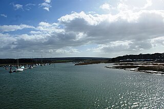
The Solent Way is a 60-mile (97 km) long-distance footpath in Hampshire, southern England. With the exception of a few inland diversions, the path follows the coast of the Solent, the sea strait that separates the mainland England from the Isle of Wight. The Solent Way forms part of the E9 European Coastal Path, which runs for 5000 km (3125 miles) from Cape St Vincent in Portugal to Narva-Jõesuu in Estonia.

Chichester Harbour is a 3,733.5-hectare (9,226-acre) biological and geological Site of Special Scientific Interest (SSSI) west of Chichester in Hampshire and West Sussex. The SSSI is part of Chichester Harbour Area of Outstanding Natural Beauty and Solent Maritime Special Area of Conservation. It is also part of Chichester and Langstone Harbours Ramsar site, Special Protection Area and Nature Conservation Review site, Grade I. Part of it is a Geological Conservation Review site and two areas are Local Nature Reserves.

Hampshire and Isle of Wight Wildlife Trust is a Wildlife Trust with 27,000 members across the counties of Hampshire and the Isle of Wight, England.

The Ribble and Alt Estuaries lie on the Irish Sea coast of the counties of Lancashire and Merseyside in north-west England, and form the boundaries of a number of conservation schemes.
Chessel Bay is the name given to the bay formed on the eastern side of a large bend in the River Itchen to the east of the district of Northam in the city of Southampton, Hampshire, England. Chessel Bay Local Nature Reserve (LNR), designated by the City Council in 1991, is located here. It comprises a narrow strip of woodland, a parallel strip of shingle and saltmarsh and a substantial area of mudflats. At low tide the mudflats are exposed attracting wading birds and wildfowl: curlew, oystercatchers and dunlin can be seen throughout the year. In winter, the site is also used as a stop-over for other migrating birds such as brent geese.

The starlet sea anemone is a species of small sea anemone in the family Edwardsiidae native to the east coast of the United States, with introduced populations along the coast of southeast England and the west coast of the United States. Populations have also been located in Nova Scotia, Canada. This sea anemone is found in the shallow brackish water of coastal lagoons and salt marshes where its slender column is usually buried in the mud and its tentacles exposed. Its genome has been sequenced and it is cultivated in the laboratory as a model organism, but the IUCN has listed it as being a "Vulnerable species" in the wild.

Keyhaven is a hamlet on the south coast of England in the county of Hampshire. It is a fishing village, but the trade has been in decline for a period of years and its main draw now is tourism, especially sailing.

The South Hampshire Coast was an Area of Outstanding Natural Beauty (AONB) in Hampshire, England, UK that was subsumed into the New Forest National Park when it was established on 1 April 2005. It lies between the New Forest and the west shore of the Solent.
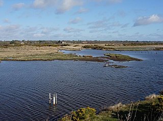
Keyhaven, Pennington, Oxey and Normandy Marshes, also known as the North Solent Marshes, are three areas of saltmarsh in Hampshire, England. The village of Keyhaven lies to the west, the village of Pennington to the north, and the town of Lymington to the northeast. The marshes lie behind Hurst Spit and fall within the Hurst Castle And Lymington River Estuary Site of Special Scientific Interest.

Alde–Ore Estuary is a 2,534 hectare biological and geological Site of Special Scientific Interest which stretches along the Suffolk coast between Aldeburgh and Bawdsey, and also includes parts of the Alde, Ore and Butley Rivers. It is in the Suffolk Coast and Heaths Area of Outstanding Natural Beauty, and is a Grade I Nature Conservation Review site, a Special Area of Conservation, a Ramsar internationally important wetland site, and a Special Protection Area under the European Union Directive on the Conservation of Wild Birds. It includes two Geological Conservation Review sites, "Orfordness and Shingle Street" and "The Cliff, Gedgrave", and two nature reserves managed by the Suffolk Wildlife Trust, Alde Mudflats and Simpson's Saltings. The coastal part of the site is Orfordness-Havergate, a National Nature Reserve, and Orford Ness is managed by the National Trust, while Havergate Island is managed by the Royal Society for the Protection of Birds.

The Hunter Estuary Wetlands comprise a group of associated wetlands at and near the mouth of the Hunter River in the city of Newcastle, New South Wales, Australia. Some 30 km2 of the wetlands has been recognised as being of international importance by designation under the Ramsar Convention. It was listed on 21 February 1984 as Ramsar site 287. A larger area of the wetlands has been identified by BirdLife International as an Important Bird Area (IBA). The wetlands are recognised as the most important area in New South Wales for waders, or shorebirds.

The Tamar–Tavy Estuary is a Site of Special Scientific Interest (SSSI) covering the tidal estuaries of the River Tamar and the River Tavy on the border between Cornwall and Devon in England, UK. Part of the Tamar estuary also forms the Tamar Estuary Nature Reserve, owned by the Cornwall Wildlife Trust. The site was designated in 1991 for its biodiversity and varying habitats that support many wader and wildfowl species, as well as the special interest of its marine biology.

Cley Marshes is a 176-hectare (430-acre) nature reserve on the North Sea coast of England just outside the village of Cley next the Sea, Norfolk. A reserve since 1926, it is the oldest of the reserves belonging to the Norfolk Wildlife Trust (NWT), which is itself the oldest county Wildlife Trust in the United Kingdom. Cley Marshes protects an area of reed beds, freshwater marsh, pools and wet meadows and is part of the North Norfolk Coast Site of Special Scientific Interest (SSSI), Special Area of Conservation (SAC), Special Protection Area (SPA), and Ramsar Site due to the large numbers of birds it attracts.
The Inner Tay Estuary, the inner, western part of the Firth of Tay, stretching from the Tay Railway Bridge in the east to the Queen's Bridge over the River Tay in Perth and the bridge in Bridge of Earn on the River Earn. The estuary is one of the largest in eastern Scotland and is up to 2.5 km wide. The estuary consists primarily of inter-tidal sand and mud flats that extend seaward out to the main channel of the estuary, the majority of which lie on the northern shore. Landward of these are saltmarsh and Phragmites reedbeds. There are two large islands: Mugdrum Island opposite Newburgh and Moncreiffe Island immediately below Perth. The narrow form of the estuary and the large volume of freshwater from the Rivers Tay and Earn restrict the influence of salt water west of the Tayport narrows. Much of the tidal water in the estuary is freshwater or mildly brackish.
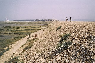
Hurst Spit is a one-mile-long (1.6 km) shingle bank near the village of Keyhaven, at the western end of the Solent, on the south coast of England. The spit shelters an area of saltmarsh and mudflats known as Keyhaven and Pennington marshes. At the end of the spit is Hurst Castle, an artillery fortress originally built on the orders of King Henry VIII, and much enlarged in the 19th century. Hurst Point Lighthouse was built on the end of Hurst Spit in the 1860s.

South Thames Estuary and Marshes is a 5,289-hectare (13,070-acre) biological Site of Special Scientific Interest which stretches between Gravesend and the mouth of the River Medway in Kent. Part of it is a Nature Conservation Review site, Grade I, and part is a Royal Society for the Protection of Birds nature reserve. It is part of the Thames Estuary and Marshes Ramsar internationally important wetland site and Special Protection Area under the European Union Directive on the Conservation of Wild Birds.

Adur Estuary is a 62.2-hectare (154-acre) biological Site of Special Scientific Interest on the western outskirts of Shoreham-by-Sea in West Sussex. Part is a Royal Society for the Protection of Birds nature reserve.