Lidar is a surveying method that measures distance to a target by illuminating the target with pulsed laser light and measuring the reflected pulses with a sensor. Differences in laser return times and wavelengths can then be used to make digital 3-D representations of the target. The name lidar, now used as an acronym of light detection and ranging, was originally a portmanteau of light and radar. Lidar sometimes is called 3D laser scanning, a special combination of a 3D scanning and laser scanning. It has terrestrial, airborne, and mobile applications.
Remote sensing is the acquisition of information about an object or phenomenon without making physical contact with the object and thus in contrast to on-site observation, especially the Earth. Remote sensing is used in numerous fields, including geography, land surveying and most Earth Science disciplines ; it also has military, intelligence, commercial, economic, planning, and humanitarian applications.
Thermal infrared spectroscopy is the subset of infrared spectroscopy that deals with radiation emitted in the infrared part of the electromagnetic spectrum. The emitted infrared radiation, though similar to blackbody radiation, is different in that the radiation is banded at characteristic vibrations in the material. The method measures the thermal infrared radiation emitted from a volume or surface. This method is commonly used to identify the composition of surface by analyzing its spectrum and comparing it to previously measured materials. It is particularly suited to airborne and spaceborne applications.
Lash or Lashing may refer to:
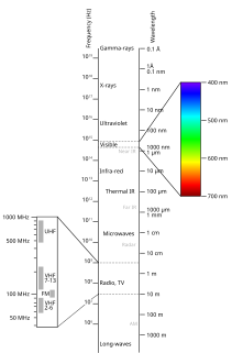
Spectral imaging is imaging that uses multiple bands across the electromagnetic spectrum. While an ordinary camera captures light across three wavelength bands in the visible spectrum, red, green, and blue (RGB), spectral imaging encompasses a wide variety of techniques that go beyond RGB. Spectral imaging may use the infrared, the visible spectrum, the ultraviolet, x-rays, or some combination of the above. It may include the acquisition of image data in visible and non-visible bands simultaneously, illumination from outside the visible range, or the use of optical filters to capture a specific spectral range. It is also possible to capture hundreds of wavelength bands for each pixel in an image.
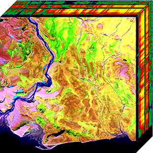
In imaging spectroscopy each pixel of an image acquires many bands of light intensity data from the spectrum, instead of just the three bands of the RGB color model. More precisely, it is the simultaneous acquisition of spatially coregistered images in many spectrally contiguous bands.
The Littoral Airborne Sensor/Hyperspectral (LASH) imaging system developed by the United States Navy combines optical imaging hardware, navigation and stabilization, and advanced image processing and algorithms to provide real-time submarine target detection, classification, and identification in littoral waters. Operating in visible and near infrared spectrum, LASH collects hyperspectral imagery using many spectral channels (colors) to exploit subtle color features associated with targets of interest. Developed as a pod-mounted system, LASH can be operated from a P-3C Orion, SH-60B Seahawk, or other platforms in support of anti-submarine warfare, mine detection, passive bathymetry, near-shore mapping, and land-based detection, discrimination and targeting.
The Florida Environmental Research Institute (FERI) is a 501(c)3 not-for-profit, research and education organization located in Tampa, Florida. Founded in 1998, FERI’s initial client was the Department of Defense (DoD) Office of Naval Research (ONR). It was ONR's funding that allowed for the development of the tools to rapidly assess the coastal ocean environment utilizing cutting edge environmental mapping and monitoring techniques, specifically hyperspectral remote sensing. Currently, FERI is responsible for a wide range of tasks spanning from the construction and aerial deployment of several digital sensor systems to the analysis of the data generated by these systems to produce informative and functional maps of U.S. coastal regions.

TacSat-3 was the third in a series of U.S. military reconnaissance satellites. It was assembled in an Air Force Research Laboratory Space Vehicles Directorate facility at Kirtland Air Force Base, New Mexico. The TacSat satellites are all designed to demonstrate the ability to provide real-time data collected from space to combatant commanders in the field. TacSat-3 includes three distinct payloads: the Advanced Responsive Tactically Effective Military Imaging Spectrometer (ARTEMIS) hyperspectral imager, the Ocean Data Telemetry Microsatellite Link and the Space Avionics Experiment.

Airborne Real-time Cueing Hyperspectral Enhanced Reconnaissance, also known by the acronym ARCHER, is an aerial imaging system that produces ground images far more detailed than plain sight or ordinary aerial photography can. It is the most sophisticated unclassified hyperspectral imaging system available, according to U.S. Government officials. ARCHER can automatically scan detailed imaging for a given signature of the object being sought, for abnormalities in the surrounding area, or for changes from previous recorded spectral signatures.
Electro-optical MASINT is a subdiscipline of Measurement and Signature Intelligence, (MASINT) and refers to intelligence gathering activities which bring together disparate elements that do not fit within the definitions of Signals Intelligence (SIGINT), Imagery Intelligence (IMINT), or Human Intelligence (HUMINT).
Multispectral remote sensing is the collection and analysis of reflected, emitted, or back-scattered energy from an object or an area of interest in multiple bands of regions of the electromagnetic spectrum. Subcategories of multispectral remote sensing include hyperspectral, in which hundreds of bands are collected and analyzed, and ultraspectral remote sensing where many hundreds of bands are used. The main purpose of multispectral imaging is the potential to classify the image using multispectral classification. This is a much faster method of image analysis than is possible by human interpretation.

Specim, Spectral Imaging Ltd is a European technology firm headquartered in Oulu, Finland. Specim manufactures and sells imaging spectrographs, hyperspectral cameras and systems. Specim's airborne AISA hyperspectral cameras have been utilized for example in monitoring the environmental effects of major industrial catastrophes such as Deepwater Horizon oil spill and Red mud spill.
Photon etc. is a Canadian manufacturer of infrared cameras, hyperspectral imaging and spectroscopic scientific instruments for academic and industrial applications. Its main technology is based on volume Bragg gratings, which are used as filters either for swept lasers or for global imaging.
PRISMA is an Italian Space Agency pre-operational and technology demonstrator mission focused on the development and delivery of hyperspectral products and the qualification of the hyperspectral payload in space.

Seafloor mapping, also called seabed imaging, is the measurement of water depth of a given body of water. Bathymetric measurements are conducted with various different methods, ranging from sonar and Lidar techniques to buoys and satellite altimetry. Various methods have advantages and disadvantages and the specific method used depends upon the scale of the area under study, financial means, desired measurement accuracy, and additional variables. Despite modern computer-based research, the ocean seabed in many locations is less measured than the topography of Mars.

HySIS is an Earth observation satellite which will provide hyperspectral imaging services to India for a range of applications in agriculture, forestry and in the assessment of geography such as coastal zones and inland waterways The data will also be accessible to India's defence forces.