Independence Avenue (Washington, D.C.)

Last updated
Independence Avenue
1900 Independence Ave SW - Washington DC.jpg
Street sign at 1900 Independence Avenue SW
Former name(s)B Street
Maintained by DDOT
Location Washington, D.C., US
West end Ohio Drive SW
Major
junctions
Maine Avenue SW
14th Street SW
Washington Avenue SW
Pennsylvania Avenue SE
Massachusetts Avenue SE
East end East Capitol Street
Construction
Commissioned1791
Completion1941

Independence Avenue is a major east-west street in the southwest and southeast quadrants of the city of Washington, D.C., in the United States, running just south of the United States Capitol. Originally named South B Street, Independence Avenue SW was constructed between 1791 and 1823. Independence Avenue SE was constructed in pieces as residential development occurred east of the United States Capitol and east of the Anacostia River. Independence Avenue SW received its current name after Congress renamed the street in legislation approved on April 13, 1934. Independence Avenue SW originally had its western terminus at 14th Street SW, but was extended west to Ohio Drive SW between 1941 and 1942. The government of the District of Columbia renamed the portion of the road in the southeast quadrant of the city (west of the Anacostia River) in 1950.

Contents

History

Map of the District of Columbia in 1818, showing the original terminus of South B Street. Washington 1818 edited.jpg
Map of the District of Columbia in 1818, showing the original terminus of South B Street.

In the District of Columbia's Cartesian-coordinate-based street-naming system, Independence Avenue was originally known as South B Street. Construction on the street began sometime after 1791. By October 1803, it existed definitively between New Jersey Avenue and 1st Street East, [1] and in 1809 it was opened between New Jersey Avenue and Pennsylvania Avenue. [2] By 1816, the entire length of the avenue appears to have been opened. [3] At the time, South B Street's western terminus was on the shore of the Potomac River, which at the time was located where 14th Street NW is now.

After terrible flooding inundated much of downtown Washington, D.C., in 1881, Congress ordered the United States Army Corps of Engineers to dredge a deep channel in the Potomac to lessen the chance of flooding. Congress also ordered that the dredged material be used to fill in what remained of the Tiber Creek estuary and build up much of the land near the White House and along Pennsylvania Avenue NW by nearly 6 feet (1.8 m) to form a kind of levee. [4] [5] [6] This "reclaimed land" — which today includes West Potomac Park, East Potomac Park, the Tidal Basin — was largely complete by 1890, and designated Potomac Park by Congress in 1897. [7] Congress first appropriated money for the beautification of the reclaimed land in 1902, which led to the planting of sod, bushes, and trees; grading and paving of sidewalks, bridle paths, and driveways; and the installation of water, drainage, and sewage pipes. [8] But South B Street was not extended through the newly reclaimed land.

In 1925, Congress authorized the construction of Arlington Memorial Bridge. The legislation specified that North B Street be treated as a major approach to Arlington Memorial Bridge. [9] The National Capital Park and Planning Commission approved the significant widening of North B Street into a ceremonial avenue. [10] On February 25, 1931, President Herbert Hoover signed legislation which renamed North B Street as Constitution Avenue. [11]

Planning for the creation of a similar ceremonial avenue to take the place of South B Street began in 1930. That year, the National Capital Park and Planning Commission (NCPPC) advocated turning the roadway into a much-widened ceremonial avenue as a counterpart to North B Street. [12] The NCPPC proposed extending South B Street west via a bridge over the Tidal Basin as a means of alleviating the traffic congestion that occurred after the closure of 13th Street NW south of Constitution Avenue. [13] The following year, the NCPPC proposed widening South B Street to 60 feet (18 m) between New Jersey Avenue SE and 12th Street SW. Between 12th and 14th Streets SW, the street would be 80 feet (24 m) wide, to accommodate the piers supporting the planned pedestrian skyways linking the United States Department of Agriculture headquarters building with the new United States Department of Agriculture South Building. All along the route, the north curb would remain in place, while the south curb moved to accommodate the new widths. [14] The NCPPC had already won the support of the Architect of the Capitol for the plan, which agreed in 1930 to move the new House office building to the south in order to accommodate the wider avenue. [12]

Planning map of the National Mall in 1932, showing the western terminus of South B Street still at 14th Street SW. National Mall and surrounding streets - Washington DC - 1932.jpg
Planning map of the National Mall in 1932, showing the western terminus of South B Street still at 14th Street SW.

The renaming of North B Street and the actions of the NCPPC encouraged local citizens to seek to rename South B Street as well. In April 1932, the Federation of Citizens Associations of Washington, D.C., petitioned Congress to rename South B Street "Washington Avenue" between the Washington Monument grounds and Pennsylvania Avenue SE. The idea was conceived by the federation's past president, Fred A. Emery, who observed that no major thoroughfare in the city commemorated George Washington (whose bicentennial birth was being celebrated that year). [15] But no action was taken in the 72nd United States Congress. Instead, Senate Joint Resolution 258 was introduced Arthur Capper (R-Kansas) in the United States Senate to change the name to Independence Avenue. [16] The Senate Committee on the District of Columbia favorably reported the bill on February 28, 1933. [17] But Congress adjourned on March 3 without further action.

The NCPPC had not given up on the idea, however. In November 1933, it approved changing the width of South B Street between 12th and 14th Streets SW to 80 feet (24 m), which helped cement in place its plan for a "future Independence Avenue". [18] At its meeting on January 18, 1934, it re-emphasized its support for the street's renaming. [19]

Congress acted swiftly to rename the street. On February 2, 1934, Senator James J. Davis (R-Pennsylvania) submitted S. 194 to accomplish this purpose. [20] The full Senate passed the bill on February 6. [21] The bill went to the United States House of Representatives, where the House Committee on the District of Columbia reported the bill favorably on March 10. [22] However, the bill was held up (along with all other D.C.-related legislation) as the House debated the Reciprocal Tariff Act. [23] Worried that the bill might stall, the Washington Board of Trade endorsed the legislation on March 30. [24] On April 5, Representative Mary T.Norton (D-New Jersey), chair of the House District of Columbia Committee, broke the logjam after appealing to the House leadership and won a full day's debate on all D.C.-related bills, including the South B Street naming bill. [25] The full House passed the bill April 9, [26] and President Franklin D. Roosevelt signed it into law on April 13, 1934. [22]

Independence Avenue on Capitol Hill, where it is a residential street for some of its length Independence Avenue on Capitol Hill.jpg
Independence Avenue on Capitol Hill, where it is a residential street for some of its length

Independence Avenue was finally extended westward through West Potomac Park in 1941 and 1942. For a decade, the NCPPC's proposal to extend the avenue westward had been opposed by the United States Department of the Interior, which opposed use of parkland for roads. There was also concern that the road would interfere with the Tidal Basin, which served as a flushing system of the downtown sewer network. But in October 1941, United States Secretary of the Interior Harold L. Ickes removed his opposition to the extension, citing the need to accommodate defense workers needing to access the national capital. The NCPPC voted on October 17, 1941, to extend the avenue west to the Potomac River. The agency was still unsure, however, whether to fill in the Tidal Basin's north bay, bridge it, or build a causeway. [27] A bridge over the north bay of the Tidal Basin was the solution, and construction on the new Kutz Memorial Bridge began in June 1942. [28]

The 1934 legislation only renamed B Street SW. B Street SE, both east and west of the Anacostia River, retained its original name. This proved immensely confusing for motorists, as the street named its named east of South Capitol Street. In 1950, the D.C. Commissioners voted to change the name of B Street SE between South Capitol Street and the Anacostia River to Independence Avenue SE. [29] B Street SE east of the Anacostia River continues to retain its original designation.

Route and landmarks

Standing on 15th Street NW, looking east at night along Independence Avenue SW USDA Bridges at Independence Avenue SW - Washington DC.jpg
Standing on 15th Street NW, looking east at night along Independence Avenue SW

The western terminus of Independence Avenue is south of the Lincoln Memorial at the intersection of Ohio Drive SW and 23rd Street SW. The street contains three lanes of traffic in each direction, and eastbound and westbound lanes are divided by a 55-foot (17 m) grassy median. The John Ericsson National Memorial is located southwest to this terminus. Going eastward, Independence Avenue passes through West Potomac Park, creating an informal boundary to the National Mall. The Korean War Veterans Memorial is adjacent to the avenue's north edge about 600 feet (180 m) east of the terminus. After passing West Basin Drive SW, motorists can see the Martin Luther King, Jr. Memorial adjacent to the roadway to the south and the District of Columbia War Memorial adjacent to the roadway to the north.

As Independence Avenue SW approaches the Tidal Basin, the westbound lanes curve north toward 17th Street SW to avoid a bay in the Basin. The John Paul Jones Memorial stands where 17th Street SW meets Independence Avenue SW. The eastbound lanes cross the Tidal Basin via the Kutz Bridge. Small off-ramps allow westbound traffic to return eastbound, and eastbound traffic to return westbound, essentially ringing the Tidal Basin bay with roadways. East of the Tidal Basin, Maine Avenue SW joins westbound Independence Avenue. An off-ramp allows eastbound Independence Avenue traffic to access Maine Avenue SW, and then an unnamed bridge creates a grade separation between elevated Independence Avenue and entrenched Maine Avenue. Both lanes of Independence Avenue curve gently through this area before moving northward to avoid the Sidney Yates Federal Building (the red brick, Romanesque Revival headquarters of the United States Forest Service). The two lanes merge into a single street with no median at Raoul Wallenberg Place SW (e.g., 14th Street SW) before curving slightly south to straighten into a formal east-west aligned ceremonial avenue.

Independence Avenue SE can be seen to the left of RFK Stadium and the D.C. Armory in this photograph. RFK Stadium aerial photo, looking towards Capitol, 1988.jpg
Independence Avenue SE can be seen to the left of RFK Stadium and the D.C. Armory in this photograph.

Between 14th Street SW and 2nd Street SW, Independence Avenue is lined with museums and federal office buildings. On the north side of the street (west to east) are the U.S. Department of Agriculture's headquarters (the Jamie L. Whitten Federal Building), the Freer Gallery of Art and Arthur M. Sackler Gallery (both art museums belonging to the Smithsonian Institution), the Smithsonian Institution Building, the National Museum of African Art, the Hirshhorn Museum and Sculpture Garden, the National Air and Space Museum, the National Museum of the American Indian, and the United States Botanic Garden. On the south side of the street (west to east) are the Department of Agriculture's South Building, the James V. Forrestal Building (headquarters of the United States Department of Energy), the Wilbur Wright Federal Building and the Orville Wright Federal Building (headquarters of the Federal Aviation Administration), the Wilbur J. Cohen Federal Building (occupied by the United States Department of Health and Human Services [HHS]), and the Hubert H. Humphrey Building (headquarters of HHS).

At 2nd Street SW, Independence Avenue SW meets Washington Avenue SW, a major thoroughfare providing access to Interstate 395 and South Capitol Street.

Independence Avenue SW/SE forms the southern boundary of the grounds of the United States Capitol. The Capitol is to the north of the street, while the Cannon, Longworth, and Rayburn House Office Buildings are to the south. Past the Capitol, Independence Avenue SE passes between the Library of Congress' Thomas Jefferson Building (north) and James Madison Memorial Building (south). The last major building along the avenue is the Library of Congress' John Adams Building (north), where Independence Avenue SE has a junction with Pennsylvania Avenue SE.

The wide, ceremonial Independence Avenue SE narrows to become a traditional residential street east of 2nd Street SE. There is a major intersection with Massachusetts Avenue SE between 14th and 15th Street SE. After 19th Street SE, Independence Avenue SE passes to the south of the D.C. Armory. The roadway then curves south and northeast around Robert F. Kennedy Memorial Stadium, passing through the stadium's parking lots.

At its eastern terminus, Independence Avenue SE becomes East Capitol Street as it reaches the Whitney Young Memorial Bridge over the Anacostia River.

Importance in the District of Columbia road network

Independence Avenue SW is a major commuting route, and carries very heavy automobile traffic during rush hour weekday mornings and evenings. At all other times, including weekends, it sees significant use by residents seeking to access Virginia via Arlington Memorial Bridge and by tour buses. From 23rd Street SW to Pennsylvania Avenue SE, Independence Avenue is part of the National Highway System.

Related Research Articles

<span class="mw-page-title-main">Pennsylvania Avenue</span> Street in Maryland and Washington, D.C., US

Pennsylvania Avenue is a primarily diagonal street in Washington, D.C. that connects the United States Capitol with the White House and then crosses northwest Washington, D.C. to Georgetown. Traveling through southeast Washington from the Capitol, it enters Prince George's County, Maryland, and becomes MD Route 4 and then MD Route 717 in Upper Marlboro, and finally Stephanie Roper Highway.

<span class="mw-page-title-main">National Mall</span> Landscaped park in Washington, D.C.

The National Mall is a landscaped park near the downtown area of Washington, D.C., the capital city of the United States. It contains and borders a number of museums of the Smithsonian Institution, art galleries, cultural institutions, and various memorials, sculptures, and statues. It is administered by the National Park Service (NPS) of the United States Department of the Interior as part of the National Mall and Memorial Parks unit of the National Park System. The park receives approximately 24 million visitors each year.

<span class="mw-page-title-main">Southwest (Washington, D.C.)</span> Southwestern quadrant of Washington, D.C.

Southwest is the southwestern quadrant of Washington, D.C., the capital of the United States, and is located south of the National Mall and west of South Capitol Street. It is the smallest quadrant of the city, and contains a small number of named neighborhoods and districts, including Bellevue, Southwest Federal Center, the Southwest Waterfront, Buzzard Point, and the military installation known as Joint Base Anacostia–Bolling.

<span class="mw-page-title-main">Congress Heights</span> Neighborhood in Washington, D.C., U.S.

Congress Heights is a residential neighborhood in Southeast Washington, D.C., in the United States. The irregularly shaped neighborhood is bounded by the St. Elizabeths Hospital campus, Lebaum Street SE, 4th Street SE, and Newcomb Street SE on the northeast; Shepard Parkway and South Capitol Street on the west; Atlantic Street SE and 1st Street SE on the south; Oxon Run Parkway on the southeast; and Wheeler Street SE and Alabama Avenue SE on the east. Commercial development is heavy along Martin Luther King, Jr. Avenue and Malcolm X Avenue.

<span class="mw-page-title-main">Constitution Avenue</span> Street in the city of Washington, D.C.

Constitution Avenue is a major east–west street in the northwest and northeast quadrants of the city of Washington, D.C., in the United States. It was originally known as B Street, and its western section was greatly lengthened and widened between 1925 and 1933. It received its current name on February 26, 1931, though it was almost named Jefferson Avenue in honor of Thomas Jefferson.

<span class="mw-page-title-main">Outdoor sculpture in Washington, D.C.</span>

There are many outdoor sculptures in Washington, D.C. In addition to the capital's most famous monuments and memorials, many figures recognized as national heroes have been posthumously awarded with his or her own statue in a park or public square. Some figures appear on several statues: Abraham Lincoln, for example, has at least three likenesses, including those at the Lincoln Memorial, in Lincoln Park, and the old Superior Court of the District of Columbia. A number of international figures, such as Mohandas Gandhi, have also been immortalized with statues. The Statue of Freedom is a 19½-foot tall allegorical statue that rests atop the United States Capitol dome.

<span class="mw-page-title-main">Whitney Young Memorial Bridge</span> Bridge in D.C., U.S.

The Whitney Young Memorial Bridge is a bridge that carries East Capitol Street across the Anacostia River in Washington, D.C. in the United States. Finished in 1955, it was originally called the East Capitol Street Bridge. It was renamed for civil rights activist Whitney Young in early 1974. The bridge is 1,800 feet (550 m) long, its six lanes are 82 feet (25 m) wide, and it has 15 spans resting on 14 piers.

<span class="mw-page-title-main">Frederick Douglass Memorial Bridge</span> Bridge crossing the Anacostia River in Washington, DC

The Frederick Douglass Memorial Bridge is a through arch bridge that carries South Capitol Street over the Anacostia River in Washington, D.C. It was completed in 2021 and replaced an older swing bridge that was completed in 1950 as the South Capitol Street Bridge. In 1965, the original bridge was renamed after abolitionist Frederick Douglass. In 2007, the original swing bridge was used by 77,000 daily commuters.

<span class="mw-page-title-main">Streetcars in Washington, D.C.</span> Streetcars that existed in Washington until 1962

Streetcars in Washington, D.C. transported people across the city and region from 1862 until 1962.

<span class="mw-page-title-main">South Capitol Street</span>

South Capitol Street is a major street dividing the southeast and southwest quadrants of Washington, D.C., in the United States. It runs south from the United States Capitol to the D.C.–Maryland line, intersecting with Southern Avenue. After it enters Maryland, the street becomes Indian Head Highway at the Eastover Shopping Center, a terminal or transfer point of many bus routes.

<span class="mw-page-title-main">M Street (Washington, D.C.)</span> Four streets of the same name in Washington, D.C.

The name "M Street" refers to two major roads in the United States capital of Washington, D.C. Because of the Cartesian coordinate system used to name streets in Washington, the name "M Street" can be used to refer to any east-west street located twelve blocks north or south of the dome of the United States Capitol. Thus, in all four quadrants of the city there are streets called "M Street", which are disambiguated by quadrant designations, namely, M Street NW, NE, SW, and SE.

<span class="mw-page-title-main">Ohio Drive</span> Street in the southwest quadrant of Washington, D.C., United States

Ohio Drive is a street in Southwest Washington, D.C., located in East and West Potomac Parks and bordering the Tidal Basin, Washington Channel, and the Potomac River. It is a central organizing feature of East Potomac Park, providing the only major vehicular route to and through the area. Unlike most roadways named after states in the District of Columbia, Ohio Drive is not an avenue, nor it is heavily used like Wisconsin or Rhode Island Avenues. However, the segment from Independence Avenue to the Rock Creek and Potomac Parkway is an important commuter route.

<span class="mw-page-title-main">Barney Circle</span> Neighborhood in the United States

Barney Circle is a small residential neighborhood located between the west bank of the Anacostia River and the eastern edge of Capitol Hill in southeast Washington, D.C., in the United States. The neighborhood is characterized by its sense of community, activism, walkability, and historic feel. The neighborhood's name derives from the eponymous former traffic circle Pennsylvania Avenue SE just before it crosses the John Philip Sousa Bridge over the Anacostia. The traffic circle is named for Commodore Joshua Barney, Commander of the Chesapeake Bay Flotilla in the War of 1812.

The streets and highways of Washington, D.C., form the core of the surface transportation infrastructure in Washington, D.C., the federal capital of the United States. Given that it is a planned city, the city's streets follow a distinctive layout and addressing scheme. There are 1,500 miles (2,400 km) of public roads in the city, of which 1,392 miles (2,240 km) are owned and maintained by city government.

<span class="mw-page-title-main">Washington Channel</span> River in the United States

The Washington Channel is a channel that parallels the Potomac River in Washington, D.C. It is located between the Southwest Waterfront on the east side and East Potomac Park on the west side. The channel is two miles (3.2 km) long, receives outflow from the Tidal Basin at its north end, and empties into the Anacostia River at Hains Point at its south end. The channel's depth ranges from 8.8 feet (2.7 m) to 23 feet (7.0 m).

<span class="mw-page-title-main">McMillan Plan</span> 1902 planning report for Washington, D.C.

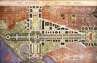
The McMillan Plan is a comprehensive planning document for the development of the monumental core and the park system of Washington, D.C., the capital of the United States. It was written in 1902 by the Senate Park Commission. The commission is popularly known as the McMillan Commission after its chairman, Senator James McMillan of Michigan.

<span class="mw-page-title-main">Greenway (Washington, D.C.)</span> Neighborhood in Ward 7, United States

Greenway is a residential neighborhood in Southeast Washington, D.C., in the United States. The neighborhood is bounded by East Capitol Street to the north, Pennsylvania Avenue SE to the south, Interstate 295 to the west, and Minnesota Avenue to the east.

<span class="mw-page-title-main">John Paul Jones Memorial</span> Statue by Charles Henry Niehaus in Washington, D.C, U.S.

The John Paul Jones Memorial, also known as Commodore John Paul Jones, is a monument in West Potomac Park, Washington, D.C. The memorial honors John Paul Jones, the United States' first naval war hero, and received the Congressional Gold Medal after the American Revolutionary War ended. Jones allegedly said "I have not yet begun to fight!" during the Battle of Flamborough Head.

<span class="mw-page-title-main">New York Avenue Bridge (Anacostia River)</span> Bridge in D.C., U.S.

The New York Avenue Bridge is a bridge carrying U.S. Route 50 and New York Avenue NE over the Anacostia River in Washington, D.C., in the United States. It was completed in 1954 as part of the Baltimore–Washington Parkway project.

<span class="mw-page-title-main">Anacostia Riverwalk Trail</span> 25 mile multi-use trail system in Washington D.C.

The Anacostia Riverwalk Trail is a multi-use trail system in Washington, DC, which, when complete, will be ~25 miles long, spanning both sides of the Anacostia River, the Washington Channel waterfront, and projecting into neighborhoods away from the Anacostia. It has more recently been branded as part of a larger Anacostia Riverwalk Trail Network which includes an additional 8 segments and 15 miles of trail. On the north end it connects to the Anacostia Tributary Trail System; on the south end it will connect to the Oxon Hill Farm Trail and on the west it connects to the Rock Creek Park Trail and the 14th Street Bridge. Of the 19 planned segments, 14 are complete for a combined total of 16 miles.

References

  1. Corporation of the City of Washington 1805, p. 20.
  2. Corporation of the City of Washington 1810, p. 7.
  3. Burch 1823, pp. 199, 207.
  4. Tindall 1914, p. 396.
  5. Gutheim & Lee 2006, pp. 94–97.
  6. Bednar 2006, p. 47.
  7. Gutheim & Lee 2006, pp. 96–97.
  8. Army Corps of Engineers 1918, p. 1891.
  9. "Grant Is Told Need of Bridge Restudy By Fine Arts Group". The Washington Post. December 28, 1926.
  10. "B Street Roadway Lines Established By Planning Group". The Washington Post. March 9, 1929.
  11. "Two Bills for District Are Signed By Hoover". The Washington Post. February 26, 1931.
  12. 1 2 National Capital Park and Planning Commission 1930, p. 59.
  13. National Capital Park and Planning Commission 1931, p. 16.
  14. National Capital Park and Planning Commission 1932, p. 40.
  15. "Steps to Rename B Street Washington Avenue Taken". The Washington Post. April 4, 1932.
  16. United States Congress 1932, p. 242.
  17. "Bingham to Speed D.C. Budget Action". The Washington Post. March 1, 1933.
  18. "Farm Buildings Will Be Linked By Single Arch". The Washington Post. November 17, 1933.
  19. "D.C. Planning Before Three Bodies Today". The Washington Post. January 18, 1934.
  20. United States Congress 1934, p. 111.
  21. "8 District Bills Are Advanced In Congress". The Washington Post. February 7, 1934.
  22. 1 2 Office of the Clerk 1934, p. 168.
  23. "House Debates Halt Action On D.C Bills". The Washington Post. March 25, 1934.
  24. "C. of C. Group Renews Move For Stadium". The Washington Post. March 31, 1934.
  25. "House Gives District Full Day on Bills". The Washington Post. April 6, 1934.
  26. "Racing, Fight Bills for D.C. Pass in House". The Washington Post. April 10, 1934.
  27. Gross, Gerald G. (October 18, 1941). "Park Board Backs Street Extension". The Washington Post.
  28. "District Awards Tidal Basin Overpass Contract". The Washington Post. June 6, 1942.
  29. "Renaming of B Street Seen As Helpful to Travellers". The Washington Post. June 20, 1950.

Bibliography

Template:Attached KML/Independence Avenue (Washington, D.C.)
KML is from Wikidata