Indian God Rock

Last updated
Indian God Rock Petroglyphs Site (36VE26)
Indian God Rock.jpg
Rear of Indian God Rock
USA Pennsylvania location map.svg
Red pog.svg
Usa edcp location map.svg
Red pog.svg
LocationSouthern side of the Allegheny River, Rockland Township, Venango County, Pennsylvania, United States [1]
Nearest city Brandon
Coordinates 41°19′48″N79°49′27″W / 41.33000°N 79.82417°W / 41.33000; -79.82417 Coordinates: 41°19′48″N79°49′27″W / 41.33000°N 79.82417°W / 41.33000; -79.82417
Area0.1 acres (0.040 ha)
Built1200
NRHP reference No. 84003585 [2]
Added to NRHPMay 14, 1984

Indian God Rock is a large boulder in the northwestern part of the U.S. state of Pennsylvania. Located near the unincorporated community of Brandon, it lies along the Allegheny River in Venango County's Rockland Township. It is significant for the large petroglyph on one of its sides. [3] :2, 3 Because of the petroglyph, the rock has been an explorers' landmark, a tourist attraction, and an object of scholarly investigation.

Contents

Geology

One of many large boulders lining the banks of the Allegheny River in Venango County, Indian God Rock is composed of sandstone and measures approximately 22×14×10 feet, [4] or 7×4×4 meters by another measurement. [3] :7 As sandstone is an easy material to carve, [5] the rock was an ideal surface for the creation of rock art. [3] :7

Early history

Among the fifty-five different figures present on Indian God Rock include geometric shapes and depictions of humans and animals in a range of positions. [3] :5 Two of the carvings appear to be images of archers; these two figures are the only known representations of archers in the Native American rock art of the Ohio River valley. [3] :2 One scholar has held that the resemblance between certain figures on the rock and drawings on extant birch bark scrolls indicates that the rock was used by tribal shamans, and he proposes that the rarity of martial themes among the carvings indicates that the carvers were members of a peaceful culture. [3] :5 Indian God Rock is not the only petroglyph site in Rockland Township; another, known as the "Rainbow Rocks Petroglyphs Site," is located at a significantly higher altitude near the community of Van, [6] :71 approximately 7.5 miles (12.1 km) to the east. [6] :115

The date of the petroglyph is uncertain; it is believed to have been carved at some point after AD 900, but most likely after 1200. The terminus ante quem for its creation is 1749, when it was recorded by multiple members of a French expedition along the Allegheny. At this time, the rock was plainly invested with religious meaning; according to one member of the expedition, accompanying Native American guides "regarded the rock with superstitious reverence." [4] Besides recording the rock and their disdain for the "savages" who created it, the expedition placed two lead plates at the site as evidence of their presence. [3] :3 During the nineteenth century, Indian God Rock became a popular tourist attraction — steamships on the Allegheny would often stop to allow their passengers to examine the petroglyph. [3] :3

Modern history

External video
Nuvola apps kaboodle.svg Weird Engravings of Indian God Rock - Petroglyphs Of Pennsylvania, Phenomenal Travel Videos [7]

Deterioration

In recent decades, the Indian God Rock has suffered significantly from erosion and vandalism. [3] :2 Since the nineteenth century, visitors have cut their names into the rock, and recent years have seen the use of spray paint by some individuals. Although archaeologists have highlighted the carvings in the past, [4] the figures are now somewhat difficult to see. [3] :2

Recognition

In the twentieth century, Indian God Rock became the object of significant archaeological investigation for the information potential of its carvings. Its place as the first Ohio River valley petroglyph to appear in written records and the continued scholarly attention to its carvings has caused it to be seen as the premier example of monumental rock art in its region. [3] :5 The United States Forest Service has recognized the rock as one of the most significant of the seventy-five Native American archaeological sites in the portion of the Allegheny River that has been designated a National Wild and Scenic River. [4] In 1984, it was further recognized when the National Park Service added it to the National Register of Historic Places. [2]

Accessibility

In 1982, the rock lay on the right-of-way for a railroad line operated by the Conrail. [3] :2 Today, the rail line is closed; [4] instead, the Middle Allegheny River Water Trail passes near the rock, and hikers can view the rock from a lookout along the trail. [8] As in the nineteenth century, Indian God Rock is also visible from watercraft on the Allegheny River. [4]

See also

Related Research Articles

Jefferson Township, Fayette County, Pennsylvania Township in Pennsylvania, United States

Jefferson Township is a township in Fayette County, Pennsylvania, United States. The population was 2,015 at the 2010 census, down from 2,259 at the 2000 census. It is named for former president Thomas Jefferson, and many of the township's streets are named after other U.S. presidents. Frazier School District serves the area.

Rockland Township, Venango County, Pennsylvania Township in Pennsylvania, United States

Rockland Township is a township in Venango County, Pennsylvania, United States. The population was 1,346 at the 2000 census. The township is quite remote, containing one general store, a Methodist church, and a volunteer fire department. A place of interest is Freedom Falls, where a waterfall and old iron furnace can be found.

Petroglyph Images carved on a rock surface as a form of rock art

A petroglyph is an image created by removing part of a rock surface by incising, picking, carving, or abrading, as a form of rock art. Outside North America, scholars often use terms such as "carving", "engraving", or other descriptions of the technique to refer to such images. Petroglyphs are found worldwide, and are often associated with prehistoric peoples. The word comes from the Greek prefix petro-, from πέτρα petra meaning "stone", and γλύφω glýphō meaning "carve", and was originally coined in French as pétroglyphe.

French Creek (Allegheny River tributary)

French Creek is a tributary of the Allegheny River in northwestern Pennsylvania and western New York in the United States.

National Register of Historic Places listings in Fayette County, Pennsylvania

This is a list of the National Register of Historic Places listings in Fayette County, Pennsylvania.

Washington State Park

Washington State Park is a public recreation area covering 2,147 acres (869 ha) in Washington County in the central eastern part of the state of Missouri. It is located on Highway 21 about 14 miles (23 km) northeast of Potosi or 7 miles (11 km) southwest of DeSoto on the eastern edge of the Ozarks. The state park is noted for its Native American rock carvings and for its finely crafted stonework from the 1930s.

Venango Path was a Native American trail between the Forks of the Ohio and Presque Isle, Pennsylvania, United States of America. The trail was named after the Native American village of Venango where French Creek flows into the Allegheny River. The village is now the site of the small city of Franklin, Pennsylvania.

Red Bird River Petroglyphs United States historic place

The Red Bird River Petroglyphs, also known as the Red Bird Petroglyphs are a series of petroglyphs, or carvings, on a stone in Clay County, Kentucky. The rock originally was situated along the Red Bird River but was moved to a park in Manchester after it fell onto the roadway below in 1994.

National Register of Historic Places listings in Belmont County, Ohio

This is a list of the National Register of Historic Places listings in Belmont County, Ohio.

National Register of Historic Places listings in Greene County, Pennsylvania

This is a list of the National Register of Historic Places listings in Greene County, Pennsylvania.

National Register of Historic Places listings in Monongalia County, West Virginia

This is a list of the National Register of Historic Places listings in Monongalia County, West Virginia.

Barnesville Petroglyph United States historic place

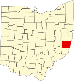
The Barnesville Petroglyph petroglyph site in the eastern part of the U.S. state of Ohio. Located approximately 3 miles (4.8 km) southwest of the village of Barnesville in Belmont County, the petroglyphs have been known both by archaeologists and the general public since the 1850s or earlier. Although the site was significantly damaged during the twentieth century, it is still a significant archaeological site, and has been named a historic site.

Sommerheim Park Archaeological District United States historic place

The Sommerheim Park Archaeological District includes a group of six archaeological sites west of Erie, Pennsylvania in the United States. The sites are in Sommerheim Park, one of the few undeveloped areas of the Lake Erie shoreline, in Millcreek Township. This district has been listed on the National Register of Historic Places. This is one of the leading archaeological sites in the Erie area and along the southern shoreline of Lake Erie, due to the amount of artifacts and the lack of disturbance on the site.

Francis Farm Petroglyphs United States historic place

The Francis Farm Petroglyphs are a group of petroglyphs in the southwestern part of the U.S. state of Pennsylvania. Located on a boulder in Jefferson Township in the northwestern portion of Fayette County, it has been known to archaeologists since at least the middle of the nineteenth century. Despite damage in the 1930s, it remains an important archaeological site, and accordingly, it has been designated a historic site.

James L. Swauger

James L. Swauger was an American archaeologist known for his work on the petroglyphs of the Ohio River valley of the United States. A native of West Newton in Westmoreland County, Pennsylvania, he moved to the Pittsburgh suburb of Edgewood in his youth; there he lived for most of the rest of his life.

Sugar Grove Petroglyphs United States historic place

The Sugar Grove Petroglyphs are a group of petroglyphs in the southwestern part of the U.S. state of Pennsylvania. Located on an outcrop of sandstone in Monongahela Township near the eastern edge of Greene County, the petroglyphs have been known since at least the 1930s. Due to their value as an archaeological site, the petroglyphs have been named a historic site.

Judaculla Rock United States historic place

Judaculla Rock is the name of an archeological site that features a curvilinear-shaped outcrop of soapstone known for its ancient carvings and petroglyphs. It is located on a 0.85-acre rectangular-shaped property, now owned by Jackson County. It is approximately 60 meters east of Caney Fork Creek, a major branch of the northwestward-trending Tuckasegee River, in the mountains of Western North Carolina.

Big and Little Indian Rock Petroglyphs United States historic place

Big and Little Indian Rock Petroglyphs is a prehistoric archaeological site located at Conestoga Township in Lancaster County, Pennsylvania. It consists of two large rocks located in the Susquehanna River. Big Indian Rock is 60 feet by 40 feet, and has carvings on all sides. The Little Indian Rock measures 38 feet by 32 feet and has carvings on the north side. The petroglyphs were first studied in 1934, and are believed to be by an Algonkian tribe.

References

  1. U.S. Geological Survey Geographic Names Information System: Indian God Rock
  2. 1 2 "National Register Information System". National Register of Historic Places . National Park Service. March 13, 2009.
  3. 1 2 3 4 5 6 7 8 9 10 11 12 Cowin, Verna L. (April 15, 1982). "National Register of Historic Places InventoryNomination Form: Indian God Rock Petroglyphs Site (36VE26)" (PDF). National Park Service. Retrieved December 8, 2009.
  4. 1 2 3 4 5 6 Hopey, Don. "Heavy History". Pittsburgh Post-Gazette , 15 April 1993. C1, C2.
  5. Archaeology Education Program Archived 2012-03-06 at the Wayback Machine . 22:1 (Winter 2004). Mississippi Valley Archaeology Center at the University of Wisconsin–La Crosse. Accessed 2009-12-08.
  6. 1 2 Swauger, James L. Rock Art of the Upper Ohio Valley. Graz: Akademische Druck und Verlagsanstalt, 1974.
  7. "Indian God Rock - Forgotten Petroglyphs Of Pennsylvania". Phenomenal place.com. Retrieved November 6, 2015.
  8. Middle Allegheny River Water Trail - Trail Guide, Pennsylvania Fish and Boat Commission. Accessed 2009-12-08.

Further reading