The land in the Ingleburn area was originally inhabited by the Tharawal people prior to the arrival of settlers from the First Fleet in 1788.[2][3] The first land grants in the area were made in 1809 to William Neale, Joshua Alliot, all previously soldiers in the NSW Corps. As such, the area became known as "Soldier Flat".[4]
In 1869, a rail platform was built on the old Neale grant and given the name Macquarie Fields Station after a property to the north. However, in 1881 the Macquarie Fields estate subdivided to become the new village of Macquarie Fields. The fact that the station was a long way from the village caused confusion so a new name was sought for the station and Ingleburn was chosen in 1883. One theory has it was named after a local house formerly owned by Mary Ruse, daughter of pioneer James Ruse. Other records indicate it was named after a British town although the corresponding town has not been identified. Ingleburn is Scottish for "bend in the river", referring to the significant bend in the nearby Georges River.
The village of Ingleburn was established in 1885 when the land owned by a developer called Fitz Stubbs was subdivided. A public school was opened in 1887. Ingleburn Post Office opened on 15 November 1886.[5] By 1896, the town was large enough to have its own municipal council. Town improvements such as street lights and water did not arrive until after World War I. In 1948 the Council was merged with the City of Campbelltown Council.
In the mid 1970’s, a large area west of the railway line was rezoned to become an industrial estate. Protests from local residents saw the plan halted temporarily but within ten years, the west side of the town had become largely industrial and remains so to this day. Multiple changes of zoning has occurred over lime from light industrial to heavy industrial. This was despite reassurances from the council that it would not affect the remaining residents. More housing subdivisions were made on the outskirts of town in the 1970s including Housing Commission developments.
Heritage listings
Ingleburn has a number of heritage-listed sites, including:
Ingleburn's central business district is adjacent to the railway station and includes two shopping centres called Ingleburn Village and Ingleburn Town Centre as well as a small shopping area on Lagonda Drive. In 2017 Ingleburn Mall was renovated and many new stores were added and relocated.
Ingleburn is the home of television playout centre MediaHub, a facility established through a joint partnership with WIN Television and ABC Television. Apart from the two networks, it also houses HD-ready playout for Seven, Imparja Television, and Fox International channels.
Ingleburn is serviced by six Interline bus routes:
868 Ingleburn Station to Edmondson Park Station
869 Ingleburn Station to Liverpool Station
870 Campbelltown Hospital to Liverpool Station
871 Campbelltown Hospital to Liverpool Station
872 Campbelltown Hospital to Liverpool Station
873 Ingleburn Station to Minto Station
Street names
Ingleburn has many themes for the naming of streets. Chester Road, Cumberland Road, Cambridge Street, Oxford Road, Suffolk Street, Carlisle Street, Norfolk Street Raglan Avenue, Belford Street, Salford Street and Phoenix Avenue were some of the first streets in the town and are named after English localities.
Birds are another theme with the main thoroughfares Warbler Avenue, Lorikeet Avenue, Currawong Street, Kingfisher Street, Oriole Place, Wagtail Crescent and Kookaburra Street, and smaller streets named after the magpie, jabiru, falcon, lark, ibis, dove, egret, kestrel, swift, heron, miner, jacana, honeyeater, lyrebird, whistler, fantail, swallow, sitella, brolga, swan, owl, quail, and triller.
There is also a car theme with Lancia Drive, Lagonda Drive, Bugatti Drive, Mercedes Road, Maserati Drive and Peugeot Drive becoming main thoroughfares and Fiat, Ferrari, Cadillac, Ford, Alfa, Renault, Rambler, Vauxhall, Buick, Leyland, Delaunay, Daimler, Stutz, Morgan, Sunbeam Place, Pontiac Place, Chevrolet Place, Delage Place and Oldsmobile Place being named after cars too.
Milton Park, shared by the boundaries of Ingleburn and Macquarie Fields is a popular venue for football and softball teams. It is also used as the presentation area for the annual Ingleburn Alive festival's evening fireworks.
Other sporting parks include Wood Park, behind Ingleburn High School where rugby league and cricket are played.
Smaller recreational reserves and parks are located between Kingfisher Road and Currawong Street, on Matthew Square, on Currawong Street behind Holy Family Catholic School and another behind Sackville Street Public School.
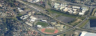
Memorial Oval can also be found on the western side of the railway line adjacent to the Ingleburn RSL Club.
Ingleburn RSL is located on Chester Road. Annually at dawn on ANZAC Day, a service is held to remember those that lost their lives serving for Australia.
Population
At the 2021 Australian census, there were 15,264 residents in Ingleburn. 52.5% of people were born in Australia. The next most common countries of birth were Bangladesh 5.4%, India 5.3% Philippines 4.2%, Nepal 4.1% and New Zealand 2.6%. 52.1% of people spoke only English at home. Other languages spoken at home included Bengali 7.2%, Hindi 4.8%, Tagalog 2.5% and Arabic 2.0%. The most common responses for religion were Catholic 22.1%, No Religion 19.5%, Islam 11.7%, Anglican 10.2% and Hinduism 9.7%.[1]
Related Research Articles
Liverpool is a suburb of South Western Sydney, in the state of New South Wales, Australia. It is located approximately 31 kilometres (19 mi) south-west of the Sydney CBD. Liverpool is the administrative seat of the local government area of the City of Liverpool and is situated in the Cumberland Plain.
The Georges River, also known as Tucoerah River, is an intermediate tide-dominated drowned valley estuary, that is located in Sydney in the state of New South Wales, Australia. The Georges River is located south and south-west from the Sydney CBD, with the mouth of the river being at Botany Bay.
Campbelltown is a suburb located on the outskirts of the metropolitan area of Sydney, New South Wales, Australia. It is located in Greater Western Sydney 53 kilometres (33 mi) south-west of the Sydney central business district by road. Campbelltown is the administrative seat of the local government area of the City of Campbelltown. It is also acknowledged on the register of the Geographical Names Board of New South Wales as one of only four cities within the Sydney metropolitan area.
Hornsby is a suburb on the Upper North Shore of Sydney in the state of New South Wales, Australia, approximately 23 kilometres (14 mi) north-west of the Sydney central business district. It is the administrative centre of the local government area of Hornsby Shire.
Eastwood is a suburb of Sydney, Australia. Eastwood is located 17 kilometres north-west of the Sydney central business district in the local government areas of the City of Ryde and the City of Parramatta. Eastwood is in the Western Sydney region. The area is best known for being an ethnic enclave for immigrant populations in Sydney, mainly of East Asian origin but the suburb also has a significant number of other immigrant populations. Eastwood was originally its own town but due to the expansion of Sydney, was eventually absorbed.
Macquarie Fields is a suburb of Sydney, in the state of New South Wales, Australia. Macquarie Fields is located 38 kilometres south-west of the Sydney central business district, in the local government area of the City of Campbelltown and is part of the Macarthur region.
Liverpool railway station is a heritage-listed railway station located on the Main South line, serving the Sydney suburb of Liverpool in Australia. It is served by Sydney Trains T2 Inner West & Leppington, T3 Bankstown and T5 Cumberland services. It was added to the New South Wales State Heritage Register on 2 April 1999.
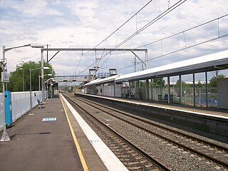
Ingleburn railway station is located on the Main South line, serving the Sydney suburb of Ingleburn. It is served by Sydney Trains T8 Airport & South line services.
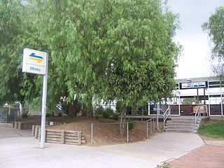
Minto railway station is located on the Main South line, serving the Sydney suburb of Minto. It is served by Sydney Trains T8 Airport & South line services.
The City of Campbelltown is a local government area in the Macarthur region of south-western Sydney, in New South Wales, Australia. The area is located about 55 kilometres (34 mi) south west of the Sydney central business district and comprises 312 square kilometres (120 sq mi).
Minto is a suburb of Sydney, in the state of New South Wales, Australia. Minto is located 50 kilometres south-west of the Sydney central business district, in the local government area of the City of Campbelltown and is part of the Macarthur region.
Leumeah is a suburb of Sydney, in the state of New South Wales, Australia 52 kilometres south-west of the Sydney central business district, in the local government area of the City of Campbelltown. It is north of the suburb of Campbelltown and is part of the Macarthur region.
Lidcombe is a suburb in western Sydney, in the state of New South Wales, Australia. Lidcombe is located 15 km (9.32 mi) west of the Sydney central business district, in the local government area of Cumberland Council, with a small industrial part in the north in the City of Parramatta. Post code: 2141, sharing it with Berala.
Edmondson Park is a suburb in the South West of Sydney, in the state of New South Wales, Australia. Edmondson Park is located 32 kilometres from the Sydney central business district, in the local government area of the City of Liverpool.
Guildford is a suburb of Sydney, in the state of New South Wales, Australia. Guildford is located 27 kilometres west of the Sydney central business district, in the local government area of Cumberland City Council. Guildford is part of the Western Sydney region. Guildford is the home of the first KFC in Australia.
Appin is a town on the south-west fringe of Sydney in the Macarthur Region in Tharawal country near its boundary with Gandangara country, New South Wales, Australia in Wollondilly Shire. It is situated about 16 kilometres (9.9 mi) south of Campbelltown and 35 kilometres (22 mi) northwest of Wollongong.
The Dubbo Regional Council is a local government area located in the Central West and Orana regions of New South Wales, Australia. The council was formed on 12 May 2016 through a merger of the City of Dubbo and Wellington Council as part of a widespread council amalgamation program. It was initially named Western Plains Regional Council for almost four months, and its name was changed to Dubbo Regional Council on 7 September 2016.
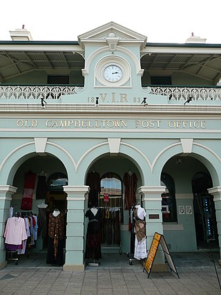
The Campbelltown Post Office is a heritage-listed former post office and now shops and office space at 261 Queen Street, Campbelltown, City of Campbelltown, New South Wales, Australia. It was designed by James Barnet and built in 1881. It is also known as Campbelltown Post Office (former). The property is privately owned. It was added to the New South Wales State Heritage Register on 2 April 1999.
Dredges Cottage is a heritage-listed former cottage and now office located at 303 Queen Street, Campbelltown in the City of Campbelltown local government area of New South Wales, Australia. The property is owned by Campbelltown City Council. It was added to the New South Wales State Heritage Register on 2 April 1999.
Macquarie Field House is a heritage-listed former farm, private school and homestead and now residence at Quarter Sessions Road, Macquarie Fields, City of Campbelltown, New South Wales, Australia. It was designed by James Meehan, James Hume and built from 1810 to 1843 by James Meehan ; Mr Burns. It is also known as Macquarie Field House and the Meehan remains; Macquariefield, Macquarie Fields and Macquarie Field. The property is privately owned. It was added to the New South Wales State Heritage Register on 2 April 1999.
This page is based on this Wikipedia article Text is available under the CC BY-SA 4.0 license; additional terms may apply. Images, videos and audio are available under their respective licenses.