
Bryce Canyon National Park is an American national park located in southwestern Utah. The major feature of the park is Bryce Canyon, which despite its name, is not a canyon, but a collection of giant natural amphitheaters along the eastern side of the Paunsaugunt Plateau. Bryce is distinctive due to geological structures called hoodoos, formed by frost weathering and stream erosion of the river and lake bed sedimentary rocks. The red, orange, and white colors of the rocks provide spectacular views for park visitors. Bryce Canyon National Park is much smaller, and sits at a much higher elevation than nearby Zion National Park. The rim at Bryce varies from 8,000 to 9,000 feet.

Thomas Moran was an American painter and printmaker of the Hudson River School in New York whose work often featured the Rocky Mountains. Moran and his family, wife Mary Nimmo Moran and daughter Ruth, took residence in New York where he obtained work as an artist. He was a younger brother of the noted marine artist Edward Moran, with whom he shared a studio. A talented illustrator and exquisite colorist, Thomas Moran was hired as an illustrator at Scribner's Monthly. During the late 1860s, he was appointed the chief illustrator for the magazine, a position that helped him launch his career as one of the premier painters of the American landscape, in particular, the American West.

The Yellowstone River is a tributary of the Missouri River, approximately 692 miles (1,114 km) long, in the western United States. Considered the principal tributary of the upper Missouri, the river and its tributaries drain a wide area stretching from the Rocky Mountains in the vicinity of Yellowstone National Park across the mountains and high plains of southern Montana and northern Wyoming.

The Grand Canyon of the Yellowstone is the first large canyon on the Yellowstone River downstream from Yellowstone Falls in Yellowstone National Park in Wyoming. The canyon is approximately 24 miles (39 km) long, between 800 and 1,200 ft deep and from .25 to .75 mi wide.

The Gallatin River is a tributary of the Missouri River, approximately 120 mi, in the U.S. states of Wyoming and Montana. It is one of three rivers, along with the Jefferson and Madison, that converge near Three Forks, Montana, to form the Missouri.

U.S. Route 89 is a north–south United States Highway with two sections, and one former section. The southern section runs for 848 miles from Flagstaff, Arizona, to the southern entrance of Yellowstone National Park. The northern section runs for 404 miles from the northern entrance of Yellowstone National Park in Montana, ending at the Canada–US border. Unnumbered roads through Yellowstone connect the two sections. Before 1992, U.S. Highway 89 was a Canada to Mexico, border-to-border, highway that ended at Nogales, Arizona, on its southern end.

U.S. Route 191 is a spur of U.S. Route 91 that has two branches. The southern branch runs for 1,465 miles (2,358 km) from Douglas, Arizona on the Mexican border to the southern part of Yellowstone National Park. The northern branch runs for 440 miles (710 km) from the northern part of Yellowstone National Park to Loring, Montana, at the Canada–US border. Unnumbered roads within Yellowstone National Park connect the two branches. The highway passes through the states of Arizona, Utah, Wyoming, and Montana.

The Lewis River is an 18.1-mile-long (29.1 km) tributary of the Snake River. The entire course of the river is located within the boundaries of Yellowstone National Park in Wyoming, US. The river is named for Meriwether Lewis, commander of the Lewis and Clark Expedition.

Yellowstone Falls consist of two major waterfalls on the Yellowstone River, within Yellowstone National Park, Wyoming, United States. As the Yellowstone river flows north from Yellowstone Lake, it leaves the Hayden Valley and plunges first over Upper Yellowstone Falls and then a quarter mile downstream over Lower Yellowstone Falls, at which point it then enters the Grand Canyon of the Yellowstone, which is up to 1,000 feet deep.

The Cook–Folsom–Peterson Expedition of 1869 was the first organized expedition to explore the region that became Yellowstone National Park. The privately financed expedition was carried out by David E. Folsom, Charles W. Cook and William Peterson of Diamond City, Montana, a gold camp in the Confederate Gulch area of the Big Belt Mountains east of Helena, Montana. The journals kept by Cook and Folsom, as well as their personal accounts to friends were of significant inspirational value to spur the organization of the Washburn-Langford-Doane Expedition which visited Yellowstone in 1870.

The Manhattan Waterfront Greenway is a foreshoreway for walking or cycling, 32 miles (51 km) long, around the island of Manhattan, in New York City. The largest portions are operated by the New York City Department of Parks and Recreation. It is separated from motor traffic, and many sections also separate pedestrians from cyclists. There are three principal parts — the East, Harlem and Hudson River Greenways.

The Hudson River Waterfront Walkway, also known as the Hudson River Walkway, is an ongoing and incomplete project located on Kill van Kull and the western shore of Upper New York Bay and the Hudson River, implemented as part of a New Jersey state-mandated master plan to connect the municipalities from the Bayonne Bridge to the George Washington Bridge with an urban linear park and provide contiguous unhindered access to the water's edge.

The Grand Loop Road Historic District encompasses the primary road system in Yellowstone National Park. Much of the 140-mile (230 km) system was originally planned by Captain Hiram M. Chittenden of the US Army Corps of Engineers in the early days of the park, when it was under military administration. The Grand Loop Road provides access to the major features of the park, including the Upper, Midway and Lower geyser basins, Mammoth Hot Springs, Tower Fall, the Grand Canyon of the Yellowstone and Yellowstone Lake.

The Gardner River is a tributary of the Yellowstone River, approximately 25 miles (40 km) long, in northwestern Wyoming and south central Montana in the United States. The entire river is located within Yellowstone National Park. It rises on the slope of Joseph Peak, Gallatin Range in the northwestern part of the park, and winds southeast through Gardner's Hole, a broad subalpine basin which is a popular trout fishing location. Angling on the Gardner is governed by Yellowstone National Park fishing regulations. After merging with Panther Creek, Indian Creek and Obsidian Creek, it then turns north and flows through a steep canyon where it cuts through a basaltic flow from approximately 500,000 years ago known as Sheepeater Cliffs. Below Sheepeater, Glen Creek out of Golden Gate Canyon and Lava Creek out of Lava Creek Canyon join the Gardner near Mammoth Hot Springs. The river crosses the 45th parallel in Gardner Canyon and is also home to a popular hot spring known as The Boiling River. The river continues north through Gardner Canyon and empties into the Yellowstone near Gardiner, Montana.

The following articles relate to the history, geography, geology, flora, fauna, structures and recreation in Yellowstone National Park.

Firehole Falls is a waterfall on the Firehole River in southwestern Yellowstone National Park in the United States. The falls are located approximately 0.5 miles (0.80 km) upstream from the confluence of the Firehole and Gibbon Rivers at Madison Junction. Firehole Falls has a drop of approximately 40 feet (12 m). The falls are located within Firehole Canyon on Firehole Canyon Drive, a one-way road that parallels the main Madison Junction to Old Faithful road.

Plaza Lafayette is a small, 0.09-acre (0.036 ha) park and surrounding streets in the Hudson Heights neighborhood of Washington Heights, Manhattan, New York City. Named after the Marquis de Lafayette, the French hero of the American Revolution, the park is roughly trapezoidal in shape, and is bounded by Riverside Drive – originally called Boulevard Lafayette in this area – on the west, the westbound lane of West 181st Street – also called "Plaza Lafayette" here – on the north, the eastbound lane of West 181st Street/Plaza Lafayette on the south, and Haven Avenue on the east. The land was acquired by the city on February 23, 1918.
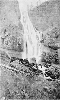
Osprey Falls is a waterfall on the Gardner River in northwestern Yellowstone National Park in the United States. Osprey Falls has a drop of approximately 150 feet (46 m). The falls are located within Sheepeater Canyon and are reachable via the Osprey Falls trail.


