Sucha Wielka is a village in the administrative district of Gmina Zawonia, within Trzebnica County, Lower Silesian Voivodeship, in south-western Poland. Prior to 1945 it was in Germany.

Nowy Śleszów is a village in the administrative district of Gmina Żórawina, within Wrocław County, Lower Silesian Voivodeship, in south-western Poland. Prior to 1945 it was in Germany. It lies approximately 7 kilometres (4 mi) south-east of Żórawina and 22 km (14 mi) south of the regional capital Wrocław.
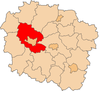
Niwki is a village in the administrative district of Gmina Tuchola, within Tuchola County, Kuyavian-Pomeranian Voivodeship, in north-central Poland.
Ruda is a village in the administrative district of Gmina Rogowo, within Rypin County, Kuyavian-Pomeranian Voivodeship, in north-central Poland. It lies approximately 5 kilometres (3 mi) north-west of Rogowo, 11 km (7 mi) south-west of Rypin, and 48 km (30 mi) east of Toruń.
Hutki is a settlement in the administrative district of Gmina Czarna Białostocka, within Białystok County, Podlaskie Voivodeship, in north-eastern Poland.
Ludwinów is a village in the administrative district of Gmina Niemce, within Lublin County, Lublin Voivodeship, in eastern Poland. It lies approximately 4 kilometres (2 mi) south of Niemce and 10 km (6 mi) north-east of the regional capital Lublin.
Łysaków Kawęczyński is a village in the administrative district of Gmina Jędrzejów, within Jędrzejów County, Świętokrzyskie Voivodeship, in south-central Poland. It lies approximately 6 kilometres (4 mi) south of Jędrzejów and 39 km (24 mi) south-west of the regional capital Kielce.
Świerczyn-Bęchy is a village in the administrative district of Gmina Drobin, within Płock County, Masovian Voivodeship, in east-central Poland.
Zielonki is a village in the administrative district of Gmina Krasne, within Przasnysz County, Masovian Voivodeship, in east-central Poland. It lies approximately 16 kilometres (10 mi) south of Przasnysz and 74 km (46 mi) north of Warsaw.
Janów is a village in the administrative district of Gmina Młodzieszyn, within Sochaczew County, Masovian Voivodeship, in east-central Poland.
Korzecznik-Podlesie is a village in the administrative district of Gmina Babiak, within Koło County, Greater Poland Voivodeship, in west-central Poland.
Rogóźno is a village in the administrative district of Gmina Przedecz, within Koło County, Greater Poland Voivodeship, in west-central Poland. It lies approximately 11 kilometres (7 mi) north of Przedecz, 28 km (17 mi) north-east of Koło, and 138 km (86 mi) east of the regional capital Poznań.
Stefanowo is a village in the administrative district of Gmina Sompolno, within Konin County, Greater Poland Voivodeship, in west-central Poland.
Laska is a settlement in the administrative district of Gmina Brusy, within Chojnice County, Pomeranian Voivodeship, in northern Poland. It lies approximately 14 kilometres (9 mi) north-west of Brusy, 26 km (16 mi) north of Chojnice, and 87 km (54 mi) south-west of the regional capital Gdańsk.
Widno is a village in the administrative district of Gmina Brusy, within Chojnice County, Pomeranian Voivodeship, in northern Poland. It lies approximately 13 kilometres (8 mi) north-west of Brusy, 26 km (16 mi) north of Chojnice, and 86 km (53 mi) south-west of the regional capital Gdańsk.
Pogorzała Wieś is a village in the administrative district of Gmina Miłoradz, within Malbork County, Pomeranian Voivodeship, in northern Poland. It lies approximately 5 kilometres (3 mi) south of Miłoradz, 10 km (6 mi) south-west of Malbork, and 48 km (30 mi) south-east of the regional capital Gdańsk.
Pruski is a village in the administrative district of Gmina Iłowo-Osada, within Działdowo County, Warmian-Masurian Voivodeship, in northern Poland. It lies approximately 5 kilometres (3 mi) north-east of Iłowo-Osada, 11 km (7 mi) east of Działdowo, and 66 km (41 mi) south of the regional capital Olsztyn.
Imno is a village in the administrative district of Gmina Goleniów, within Goleniów County, West Pomeranian Voivodeship, in north-western Poland. It lies approximately 8 kilometres (5 mi) east of Goleniów and 28 km (17 mi) north-east of the regional capital Szczecin.
Stołąż is a village in the administrative district of Gmina Brojce, within Gryfice County, West Pomeranian Voivodeship, in north-western Poland. It lies approximately 3 kilometres (2 mi) south of Brojce, 11 km (7 mi) east of Gryfice, and 77 km (48 mi) north-east of the regional capital Szczecin.
Marijan is a village in Behrestagh Rural District, in the Central District of Amol County, Mazandaran Province, Iran. At the 2006 census, its population was 28, in 7 families.