Jamnica, Prevalje

Last updated
Jamnica
Zgornja Jamnica (1955–1998)
Slovenia location map.svg
Red pog.svg
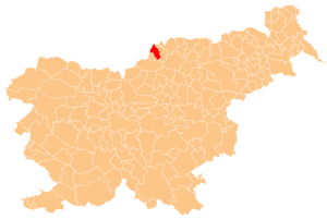
Jamnica
Location in Slovenia
Coordinates: 46°35′43.66″N14°52′35.1″E / 46.5954611°N 14.876417°E / 46.5954611; 14.876417 Coordinates: 46°35′43.66″N14°52′35.1″E / 46.5954611°N 14.876417°E / 46.5954611; 14.876417
Country Flag of Slovenia.svg Slovenia
Traditional region Carinthia
Statistical region Carinthia
Municipality Prevalje
Area
  Total 6.04 km2 (2.33 sq mi)
Elevation 785.7 m (2,577.8 ft)
Population (2002)
  Total 71
[1]

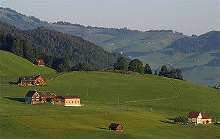
Jamnica (pronounced  [jaˈmniːtsa] ) is a dispersed settlement in the hills northwest of Prevalje in the Carinthia region in northern Slovenia, right on the border with Austria. [2]

Dispersed settlement Rural settlement type, typically consists of widely spaced farmsteads without an actual nucleus

A dispersed settlement, also known as a scattered settlement, is one of the main types of settlement patterns used by landscape historians to classify rural settlements found in England and other parts of the world. Typically, there are a number of separate farmsteads scattered throughout the area. A dispersed settlement contrasts with a nucleated village.

Prevalje Town and Municipality in Slovenia

Prevalje is a settlement and a municipality in northern Slovenia. It lies in the traditional Slovenian province of Carinthia. On 1 January 1999 Prevalje became an independent municipality. Prevalje lies in a valley where the Meža River emerges from a narrow gorge, full of fluvioglacial sediments. To the north the settlement is limited by the Strojna, Stražišče, and Dolga Brda hills. To the south are Navrski vrh and Riflov vrh.

Slovenia republic in Central Europe

Slovenia, officially the Republic of Slovenia, is a sovereign state located in southern Central Europe at a crossroads of important European cultural and trade routes. It is bordered by Italy to the west, Austria to the north, Hungary to the northeast, Croatia to the southeast, and the Adriatic Sea to the southwest. It covers 20,273 square kilometers (7,827 sq mi) and has a population of 2.07 million. One of the successor states of the former Yugoslavia, Slovenia is a parliamentary republic and a member of the United Nations, of the European Union, and of NATO. The capital and largest city is Ljubljana.

Contents

Name

The name of the settlement was changed from Jamnica to Zgornja Jamnica (literally, 'upper Jamnica') in 1955. [3] This corresponded to the name change of Šentanel to Spodnja Jamnica (literally, 'lower Jamnica') the same year. The name Jamnica was restored in 1998. [4]

Šentanel in Carinthia, Slovenia

Šentanel is a settlement in the hills northwest of Prevalje in the Carinthia region in northern Slovenia.


Related Research Articles

Benedikt, Benedikt Place in Styria, Slovenia

Benedikt is the central settlement in the Municipality of Benedikt in northeastern Slovenia. Before 1998, it was part of the Municipality of Lenart. It lies in the Slovene Hills. The area was part of the traditional region of Styria. It is now included in the Drava Statistical Region.

Škocjan, Koper Village in Littoral, Slovenia

Škocjan is a settlement on the outskirts of Koper in the Littoral region of Slovenia.

Jamnica can refer to:

Gozd Martuljek Place in Upper Carniola, Slovenia

Gozd Martuljek is a settlement in the Municipality of Kranjska Gora in the Upper Carniola region of Slovenia. The settlement was once called Rute and even today divided into Spodnje Rute and Zgornje Rute.

Koprivnik v Bohinju Place in Upper Carniola, Slovenia

Koprivnik v Bohinju is a settlement on the Pokljuka Plateau in the Municipality of Bohinj in the Upper Carniola region of Slovenia.

Sveti Lenart, Škofja Loka Place in Upper Carniola, Slovenia

Sveti Lenart is a village in the Municipality of Škofja Loka in the Upper Carniola region of Slovenia.

Rovte v Selški Dolini Place in Upper Carniola, Slovenia

Rovte v Selški Dolini is a settlement in the Municipality of Škofja Loka in the Upper Carniola region of Slovenia.

Kneške Ravne Place in Slovenian Littoral, Slovenia

Kneške Ravne is a dispersed settlement in the hills north of the Bača Valley in the Municipality of Tolmin in the Littoral region of Slovenia. It lies in the southern border area of Triglav National Park and is a popular starting point for hikes in the southwestern Julian Alps. The settlement has been part of the park since 2010.

Kot pri Prevaljah in Carinthia, Slovenia

Kot pri Prevaljah is a dispersed settlement in the hills south of Prevalje in the Carinthia region in northern Slovenia.

Strmec pri Svetem Florijanu Place in Styria, Slovenia

Strmec pri Svetem Florijanu is a settlement in the Municipality of Rogaška Slatina in eastern Slovenia. The entire area was traditionally part of the region of Styria. It is now included in the Savinja Statistical Region.

Draga pri Sinjem Vrhu Place in White Carniola, Slovenia

Draga pri Sinjem Vrhu is a small settlement south of Sinji Vrh in the Municipality of Črnomelj in the White Carniola area of southeastern Slovenia. The area is part of the traditional region of Lower Carniola and is now included in the Southeast Slovenia Statistical Region.

Prevalje pod Krimom Place in Inner Carniola, Slovenia

Prevalje pod Krimom is a settlement in the Municipality of Brezovica in central Slovenia. The municipality is part of the traditional region of Inner Carniola and is now included in the Central Slovenia Statistical Region.

Mala Sela, Litija Place in Styria, Slovenia

Mala Sela is a small settlement west of Vače in the Municipality of Litija in central Slovenia. Traditionally the area was part of Styria and is now included with the rest of the municipality in the Central Slovenia Statistical Region.

Čeče Place in Styria, Slovenia

Čeče is a settlement in central Slovenia. It lies in the hills northeast of the town of Trbovlje. Administratively it is divided between the municipalities of Trbovlje and Hrastnik. Traditionally the area was part of the Styria region. It is now included in the Central Sava Statistical Region.

Podgaj, Šentjur Place in Styria, Slovenia

Podgaj is a small settlement south of Ponikva in the Municipality of Šentjur in eastern Slovenia. Traditionally the area is part of Styria. The municipality is now included in the Savinja Statistical Region.

Vavpča Vas pri Dobrniču Place in Lower Carniola, Slovenia

Vavpča Vas pri Dobrniču is a settlement in the Municipality of Trebnje in eastern Slovenia. It lies in a small valley north of Dobrnič. Traditionally the area was part of Lower Carniola. The municipality is now included in the Southeast Slovenia Statistical Region.

Hrastje pri Grosupljem in Lower Carniola, Slovenia

Hrastje pri Grosupljem is a settlement between Grosuplje and Šmarje-Sap in central Slovenia. The Slovenian A2 motorway runs across the settlement's territory. The area is part of the historical region of Lower Carniola. The Municipality of Grosuplje is now included in the Central Slovenia Statistical Region.

Podgorica pri Šmarju in Lower Carniola, Slovenia

Podgorica pri Šmarju is a small settlement just north of Šmarje–Sap in the Municipality of Grosuplje in central Slovenia. The area is part of the historical region of Lower Carniola and is now included in the Central Slovenia Statistical Region.

References

  1. Statistical Office of the Republic of Slovenia
  2. Prevalje municipal site
  3. Spremembe naselij 1948–95. 1996. Database. Ljubljana: Geografski inštitut ZRC SAZU, DZS.
  4. "Odlok o spremembi območij, razdružitvi in poimenovanju naselij v Občini Ravne-Prevalje." Uradni list Republike Slovenije, no. 13/1998