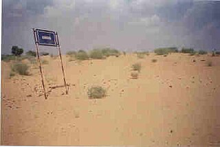
Thathawata is a village located in Churu District of Rajasthan state in India. At the 2001 census, the village had a total population of 2500.

Ratangarh (रतनगढ) is a town in the Churu district in Rajasthan, India. Ratangarh was previously called Kolasar. It is famous for grand havelis (mansions) with frescoes, which is an architectural specialty of the Shekhawati region. Ratangarh is also famous for its handicraft work.
Sujangarh is a city in the Churu district in the Shekhawati region of Rajasthan, India. Sujangarh is on the Ambala-Pali Highway and Hanumangarh-Kishangarh Mega Highway.

Churu district is a district of the Indian state of Rajasthan in northern India. The town of Churu is the administrative headquarters of the district.
Chhapar is a small town and a municipality in Churu district in the state of Rajasthan, India. Chhapar and Tal chhapar is located in the Churu district of Northwestern Rajasthan in the Shekhawati region of India. It is 210 km from Jaipur and situated on the road from Ratangarh to Sujangarh. The Tal Chappar lies in the Sujangarh Tehsil of Churu district. It lies on the Nokha-Sujangarh state highway and is situated at a distance of 85 km from Churu and about 132 km from Bikaner. The nearest railway station is Chappar which lies on Degana-Churu-Rewari broad gauge line of Northern Western Railways. The nearest Airport is Jaipur International Airport (Sanganer) which is at a distance of 215 km from Chappar. It is known for black bucks but it is also home to a variety of birds. Here is a famous sanctuary known as Tal Chhapar Sanctuary
Churu Lok Sabha constituency is one of the 25 Lok Sabha (parliamentary) constituencies in Rajasthan state in India.
Bana is a village situated in Bikaner district in Rajasthan, India. It is situated 10 km south of Sri Dungargarh city. It was founded by Bana (clan) Jats.
Bhukaredi is a village in Ratangarh tehsil of Churu district in Rajasthan. This village was founded by Bhukar gotra Jats.
Mangloona is a village in Laxmangarh tehsil in Sikar district, Rajasthan. It is situated on Laxmangarh to Salasar Road near the border of Churu district.
Rosawa is a village in Fatehpur tehsil of Sikar district of Rajasthan. It is located in west direction at a distance of about 15 km from Fatehpur. It had the oldest middle school in the area which played a great role in educating Jats of the area.
Biramsar is a village in Ratangarh tehsil of Churu district of Rajasthan, India.
{{Infobox settlement | name = Gagarwas | native_name = | native_name_lang = | other_name = | nickname = | settlement_type = village | image_skyline = | image_alt = | image_caption = | pushpin_map = India Rajasthan#India | pushpin_label_position = right | pushpin_map_alt = | pushpin_map_caption = Location in Rajasthan, India, India | coordinates = 28°39′N75°31′E | subdivision_type = Country | subdivision_name = India | subdivision_type1 = State | subdivision_name1 = [[Rajasthan, India]] | subdivision_type2 = District | subdivision_name2 = Churu | established_title = | established_date = | founder = | named_for = | government_type = | governing_body = | unit_pref = Metric | area_footnotes = | area_rank = | area_total_km2 = | elevation_footnotes = | elevation_m = | population_total = 2500 | population_as_of = 2010 | population_rank = | population_density_km2 = auto | population_demonym = | population_footnotes = | demographics_type1 = Languages | demographics1_title1 = Official | demographics1_info1 = | timezone1 = IST | utc_offset1 = +5:30 | postal_code_type = | postal_code = | registration_plate = | blank1_name_sec1 = Nearest city | blank1_info_sec1 = Sadulpur | blank1_name_sec2 = Climate | blank1_info_sec2 = warm (Köppen) | website = | iso_code = RJ-IN | footnotes =
Rajiasar is a cluster of three villages located in the Churu district of Rajasthan.
Nimakidhani is a village located in Ramgarh Shekhawati tehsil, Sikar district, within the Jaipur division, in the Indian state of Rajasthan. The village was founded by late Shri Nyoldanji Kavia in the year 1539 of the Vikram Samwat calendar. Lying on the border of three districts, Sikar, Jhunjhunu, and Churu, it is part of the historical region of Shekhawati and has a sub-tropical semi-arid climate.The nearest railway station Ramgarh Shekhawati is well connected by trains with Jaipur and Churu. The Karanimata mandir of this village is very important, statue was placed by Baldanji kavia and regular Puja Archana (worshiping) is being performed by shri Prabhudan ji kavia. Overview Neema Ki Dhani is a small village located in Fatehpur Tehsil of Sikar district, Rajasthan with total 75 families residing. The Neema Ki Dhani village has population of 431 of which 226 are males while 205 are females as per Population Census 2011.

Sardarshahar Assembly constituency is one of constituencies of Rajasthan Legislative Assembly in the Churu.
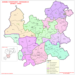
Ratangarh Assembly constituency is one of constituencies of Rajasthan Legislative Assembly in the Churu.

Malwas is a village and post in the Churu district of northern Rajasthan state, India.
Deengli is a village in Rajgarh, Churu, Rajasthan, India. As per 2011 Census of India, the village has population of 2197 of which 1144 are males while 1053 are females. It comes under ‘’’Sulkhnia chhotta’’’ Panchayath. It belongs to Bikaner Division. As per constitution of India and Panchyati Raaj Act, Deengli village is administrated by Sarpanch who is elected representative of village. It is located 65 km towards East from District headquarters Churu. 230 km from State capital Jaipur. The most famous place in Deengli is Net Dada JI temple.
Randhisar (रणधीसर) is a small village and a Panchayat in Churu district in the state of Rajasthan, India. It is located in the Shekhawati region. The local language is Hindi. It is 220 km from Jaipur and situated on the road from Ratangarh to Sujangarh. The village of Randhisar lies in Sujangarh tehsil of Churu district. The nearest Railway station is Chappar, which lies on Degana-Churu-Rewari broad gauge rail line. The nearest Airport is at Sanganer, 225 km away. Randhisar is famous for their mining industries and good quality of building material grit. Most of the residents are Rajpurohit, and maintain traditions that are similiar to the Brahmins and Rajputs.The Sarpanch is Bhawani Singh Randhisar. There are three temples associated with the village: Ambe Maa Temple, Shivdayalya Temple, thakur ji tample, Balaji Temple. It also has the distinction of being Sujangarh District's first ODF Village.
