Related Research Articles

The blizzard of 1977 hit Western New York and Southern Ontario from January 28 to February 1 of that year. Daily peak wind gusts ranging from 46 to 69 mph were recorded by the National Weather Service in Buffalo,with snowfall as high as 100 in (254 cm) recorded in areas,and the high winds blew this into drifts of 30 to 40 ft. There were 23 total storm-related deaths in Western New York,with five more in northern New York.
This article describes severe weather terminology used by the National Weather Service (NWS) in the United States. The NWS is a government agency operating as an arm of the National Oceanic and Atmospheric Administration (NOAA) branch. It defines precise meanings for nearly all of its weather terms.

North Dakota's climate is typical of a continental climate with cold winters and warm-hot summers. The state's location in the Upper Midwest allows it to experience some of the widest variety of weather in the United States,and each of the four seasons has its own distinct characteristics. The eastern half of the state has a humid continental climate with warm to hot,somewhat humid summers and cold,windy winters,while the western half has a semi-arid climate with less precipitation and less humidity but similar temperature profiles. The areas east of the Missouri River get slightly colder winters,while those west of the stream get higher summer daytime temperatures. In general,the diurnal temperature difference is prone to be more significant in the west due to higher elevation and less humidity.

The February 25–27,2010 North American blizzard was a winter storm and severe weather event that occurred in the Mid-Atlantic and New England regions of the United States between February 24 and 26,2010. The storm dropped its heaviest snow of 12 to 24 inches across a wide area of interior New England,New York,and Pennsylvania. The storm also brought flooding rains to coastal sections of New England,with some areas experiencing as much as 4 inches (10 cm). Aside from precipitation,the nor'easter brought hurricane-force sustained winds to coastal New England.
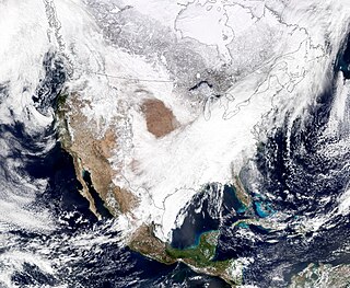
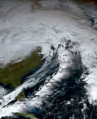
Global weather activity of 2007 profiles the major worldwide weather events,including blizzards,ice storms,tornadoes,tropical cyclones,and other weather events,from January 1,2007,to December 31,2007. Winter storms are events in which the dominant varieties of precipitation are formed during cold temperatures;they include snow or sleet,or a rainstorm where ground temperatures are cold enough to allow ice,including freezing rain,to form. Thehy may be marked by strong wind,thunder,lightning thunderstorms,heavy precipitation,including ice storm,wind transporting some substance through the atmosphere,including dust storms,snowstorms,and hail storms. Other major non winter events such as large dust storms,hurricanes,cyclones,tornados,gales,flooding,and rainstorms are also caused by such phenomena.

The 2011 Groundhog Day blizzard was a powerful and historic winter storm that affected large swaths of the United States and Canada from January 31 to February 2,2011,especially on Groundhog Day. During the initial stages of the storm,some meteorologists predicted that the system would affect over 100 million people in the United States. The storm brought cold air,heavy snowfall,blowing snow,and mixed precipitation on a path from New Mexico and northern Texas to New England and Eastern Canada. The Chicago area saw 21.2 inches (54 cm) of snow and blizzard conditions,with winds of over 60 mph (100 km/h). With such continuous winds,the blizzard continued to the north and affected Eastern and Atlantic Canada. Blizzard conditions affected many other large cities along the storm's path,including Tulsa,Oklahoma City,Kansas City,St. Louis,Springfield,El Paso,Las Cruces,Des Moines,Milwaukee,Detroit,Indianapolis,Dayton,Cleveland,New York City,New York's Capital District,and Boston. Many other areas not normally used to extreme winter conditions,including Albuquerque,Dallas and Houston,experienced significant snowfall or ice accumulation. The central Illinois National Weather Service in Lincoln,Illinois,issued only their fourth blizzard warning in the forecast office's 16-year history. Snowfall amounts of 20 to 28 inches were forecast for much of Northern and Western Illinois.

The January–March 2014 North American cold wave was an extreme weather event that extended through the late winter months of the 2013–2014 winter season,and was also part of an unusually cold winter affecting parts of Canada and parts of the north-central and northeastern United States. The event occurred in early 2014 and was caused by a southward shift of the North Polar Vortex. Record-low temperatures also extended well into March.

The 2013–14 North American winter was one of the most significant for the United States,due in part to the breakdown of the polar vortex in November 2013,which allowed very cold air to travel down into the United States,leading to an extended period of very cold temperatures. The pattern continued mostly uninterrupted throughout the winter and numerous significant winter storms affected the Eastern United States,with the most notable one being a powerful winter storm that dumped ice and snow in the Southeastern United States and the Northeastern United States in mid-February. Most of the cold weather abated by the end of March,though a few winter storms did affect the Western United States towards the end of the winter.

The 2015–16 North American winter was not as frigid across North America and the United States as compared to the 2013–14 and 2014–15 winters. This was mainly due to a strong El Niño,which caused generally warmer-than-average conditions. However,despite the warmth,significant weather systems still occurred,including a snowstorm and flash flooding in Texas at the end of December and a large tornado outbreak at the end of February. The main event of the winter season,by far and large,was when a crippling and historic blizzard struck the Northeastern United States in late January,dumping up to 3 feet of snow in and around the metropolitan areas. Several other smaller snow events affected the Northeast as well,but for the most part the heaviest snowstorms and ice stayed out further west,such as a severe blizzard in western Texas in late December,and a major late-season snowstorm in Colorado in mid-April.

The 2011–12 North American winter by and large saw above normal average temperatures across North America,with the Contiguous United States encountering its fourth-warmest winter on record,along with an unusually low number of significant winter precipitation events. The primary outlier was Alaska,parts of which experienced their coldest January on record.

The 2016–17 North American winter was quite warm across North America in general,due in part to a weak La Niña that was expected to influence weather conditions across the continent. Several notable events occurred during the season,including a potent winter storm that affected the East Coast of the United States in early January,the second-largest winter tornado outbreak on record later that month,and an unusually warm February. In addition,towards the end of the season,a large cyclonic storm system that caused a large tornado outbreak,flooding,and a potent blizzard occurred in the Heartland of the country. However,the most notable event of the winter was a powerful blizzard that impacted the Northeast and New England in mid-March,towards the end of the season.

The 2017–18 North American winter saw weather patterns across North America that were very active,erratic,and protracted,especially near the end of the season,resulting in widespread snow and cold across the continent during the winter. Significant events included rare snowfall in the South,an outbreak of frigid temperatures that affected the United States during the final week of 2017 and early weeks of January,and a series of strong nor'easters that affected the Northeastern United States during the month of March. In addition,flooding also took place during the month of February in the Central United States. Finally the winter came to a conclusion with a powerful storm system that caused a tornado outbreak and blizzard in mid-April. The most intense event,however,was an extremely powerful cyclonic blizzard that impacted the Northeastern United States in the first week of 2018. Similar to the previous winter,a La Niña was expected to influence the winter weather across North America.

The January 2018 North American blizzard caused widespread severe disruption and blizzard conditions across much of the East Coasts of the United States and Canada in early January 2018. The storm dropped up to 2 feet of snow in the Mid-Atlantic states,New England,and Atlantic Canada,while areas as far south as southern Georgia and far northern Florida had brief wintry precipitation,with 0.1 inches of snow measured officially in Tallahassee,Florida. The storm originated on January 3 as an area of low pressure off the coast of the Southeast. Moving swiftly to the northeast,the storm explosively deepened while moving parallel to the Eastern Seaboard,causing significant snowfall accumulations. The storm received various unofficial names,such as Winter Storm Grayson,Blizzard of 2018 and Storm Brody. The storm was also dubbed a "historic bomb cyclone".

The 2018–19 North American winter was unusually cold within the Northern United States,with frigid temperatures being recorded within the middle of the season. Several notable events occurred,such as a rare snow in the Southeast in December,a strong cold wave and several major winter storms in the Midwest,and upper Northeast and much of Canada in late January and early February,record snowstorms in the Southwest in late February,deadly tornado outbreaks in the Southeast and a historic mid-April blizzard in the Midwest,but the most notable event of the winter was a record-breaking bomb cyclone that affected much of the Central United States and Canada in mid-March. Unlike previous winters,a developing weak El Niño was expected to influence weather patterns across North America. Overall,however,winter of 2018–19 had many La Niña like conditions,being mild along the mid- and lower parts of the East Coast,the West Coast,and most of the southern Plains. Overall,the meteorological winter of 2018-19 became the wettest on record for the United States.

The 2019–20 North American winter was unusually warm for many parts of the United States;in many areas,neutral ENSO conditions controlled the weather patterns,resulting in strong El Niño like conditions and the sixth-warmest winter on record,and many areas in the Northeastern United States saw one of the least snowy winters in years. In fact,Baltimore and Islip saw no snow in February for the first time. Some notable events still occurred,such as a powerful blizzard that impacted the Western United States in late November,a series of cold shots in January and February,a snowstorm within the Texas Panhandle and a late-season blizzard in the High Plains.

The 2020–21 North American winter was the most significant winter season to affect North America in several years,and the costliest on record,with a damage total of at least $33.35 billion. The season featured six storms ranking on the Regional Snowfall Index scale (RSI),with four storms ranking as at least a Category 3. Most of the winter's damage and fatalities occurred due to a historic and major cold wave in mid-February. Several other significant events occurred,including a crippling early-season ice storm in the Southern Plains,a powerful nor'easter in mid-December,another major nor'easter in early February,two major and widespread winter storms in mid-February,and a major blizzard in the Rocky Mountains in mid-March. The winter-related events were responsible for at least 358 fatalities,making it the deadliest season since 1992–93. A La Niña pattern influenced much of the winter in North America.
The 2021–22 North American winter was not as significant and record-breaking as the previous winter season. Despite this,several notable and significant events still occurred,including two separate record-breaking tornado outbreaks in mid-December,a significant winter storm in the South in mid-January,a powerful blizzard that impacted the Northeast coast at the end of January and a wide-ranging,significant winter storm that affected most of the eastern half of the country in early February. Additional significant events included a late-season winter storm in March that affected the Appalachian Mountains,and a major blizzard that affected North and South Dakota in mid-April. Additionally,a very late out-of-season snowstorm struck the Rocky Mountains in late May. During the season,four storms have been ranked on the Regional Snowfall Index (RSI),although none attained the “Major”category. Similar to the previous winter,a developing La Niña was expected to influence weather patterns across the continent.
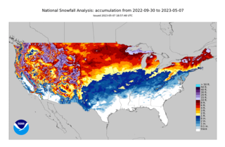
The 2022–23 North American winter was an unusually warm winter for the east and an unusually cold winter for the west in North America,as it occurred across the continent from late 2022 to early 2023. The winter season in North America began at the winter solstice,which occurred on December 21,2022,and it ended at the March equinox,which occurred on March 20,2023. The first day of meteorological winter began on December 1 and unofficially ended on February 28;winter storms may still occur outside of these limits.
From December 21 to 26,2022,an extratropical cyclone created crippling winter storm conditions,including blizzards,high winds,snowfall,and record cold temperatures across the majority of the United States and parts of Canada. Areas which experienced blizzard conditions included parts of Minnesota,Iowa,Wisconsin,Michigan,Ohio,Pennsylvania,New York and Ontario,with the Buffalo area of New York and the Fort Erie and Kingston areas of Ontario experiencing almost two full days of blizzard/zero-visibility conditions starting from December 23. The cold wave affected all U.S. states from Colorado to the Eastern Seaboard,with effects felt as far south as Miami,Florida. On December 24,110 million people across 36 states were subject to wind chill alerts.

The 2023–24 North American winter was the warmest winter on record across the contiguous United States,with below-average snowfall primarily in the Upper Midwest and parts of the Northeastern United States. However,some areas,especially in the states of Pennsylvania,New Jersey and New York saw considerably more snow than the previous winter. Notable winter events were also more prevalent across the eastern half of the country this winter,including a series of winter storms in mid-January that brought snow from the South to Northeast states,a period of very cold temperatures across much of the country in mid-to-late January,and a disruptive nor'easter that affected much of the Mid-Atlantic in mid-February. 2 storms have been rated so far on the Regional Snowfall Index (RSI),although none have attained a "Major" rating. A strong El Niño was expected to influence the winter weather patterns across the continent.
References
- 1 2 3 Winter Storm Gerri Wraps Up In Great Lakes After Bringing Blizzard To Midwest, Northwest (RECAP), The Weather Channel, January 13, 2024
- ↑ Vicious storm triggers historic coastal flooding as Arctic chill tees up the South’s first snow, CNN, January 14, 2024
- ↑ Winter storm Gerri blasts much of the U.S., United Press International, January 12, 2024
- ↑ CRATER LAKE NATIONAL PARK CLOSED DUE TO STORMY CONDITIONS, KQEN News Radio 1240, January 12, 2024
- ↑ Winter Storm Gerri A Second Late-Week Strike Of Snow, Severe Weather, Winds, Rain, Then Coldest Air Of Season, The Weather Channel, January 15, 2024
- ↑ Seattle area could see coldest temps in 33 years as brutal chill sweeps through region, KIRO7, January 13, 2024
- ↑ Brutal arctic blast blanketing much of the US is set to deliver record cold temperatures as the South braces for snow and ice, CNN, January 15, 2023
- ↑ Portland area winter storm: 3 dead; hundreds of thousands lose power, KGW8, January 13, 2024
- ↑ Arctic Blast of January 2024, ARCGIS, February 28, 2024
- ↑ Hundreds of Flights Canceled, Airlines Issue Advisories, As Winter Storm Slams Midwest, Travel and Leisure, January 12, 2024
- ↑ Winter Storm Gerri: Dangerous Cold Moves In; Travel Remains Hazardous, Weather Underground, January 14, 2024
- ↑ Great Lakes region faces feet of lake-effect snow as Midwest winter storm winds down, Fox Weather, January 13, 2024
- ↑ Almost every US state is under a weather alert as storms sweep across the country, ABC News, January 13, 2024
- ↑ AMTRAK SERVICE RESUMES FOLLOWING SUSPENSION DUE TO FLOODING; SOME METRO-NORTH SERVICE SUSPENDED, ABC7NY, January 13, 2024
- ↑ WEATHER: NYS prepares for winter storm, flooding continues across the Tri-State and a chilly NYC could soon see snow, Audacy, January 13, 2024
- ↑ Coastal flooding inundates parts of New York City after storm, Gothamist, January 13, 2024
- ↑ Most roads in Mystic and Groton reopen now that water has receded, NBC Connecticut, January 13, 2024
- ↑ Storm brings more rain, with power outages, high coastal water, and possible flooding, Boston.com, January 13, 2024
- ↑ Field Observations: Real-Time Data from the January 13 Storm & Flooding in Boston, Stone Living Lab, January 16, 2024
- ↑ Vicious storm triggers historic coastal flooding as Arctic chill tees up the South’s first snow, CNN, January 14, 2024
- ↑ Maine Event Reports: January 13-14, 2024, NCEI
- ↑ Cold weather, power failures continue in aftermath of Oregon storm, OPB, January 14, 2024
- ↑ ‘All-hands-on-deck’ effort, diverse energy sources aid storm response, The Wire, January 17, 2024