
Amarkantak is a pilgrim town and a Nagar Panchayat in Anuppur, Madhya Pradesh, India. The Amarkantak region is a unique natural heritage area and is the meeting point of the Vindhya and the Satpura Ranges, with the Maikal Hills being the fulcrum. This is where the Narmada River, the Son River and Johilla River originate.

Harda District is a district of Madhya Pradesh state of central India. The town of Harda is the district headquarters. The district is part of Narmadapuram Division. Harda district was organized in 1998.Harda is also known as 'Hridaynagari'.

Datia District is in Gwalior Division in the Indian state of Madhya Pradesh. The town of Datia is its district headquarters.
Panna district is a district of the Sagar Division, within the Madhya Pradesh state in central India. The town of Panna is the district headquarters.

Mandla District is a district of Madhya Pradesh in central India. The town of Mandla is the administrative headquarters of the district. It is part of Jabalpur Division.

Guna district is one of the 52 districts of Madhya Pradesh in central India. Its administrative headquarters is Guna. The district has a population of 1,241,519. It has an area of 6390 km², and is bounded on the northeast by Shivpuri District, on the east by Ashoknagar District, on the southeast by Vidisha District, on the southwest by Rajgarh District, on the west and northwest by Jhalawar and Baran districts of Rajasthan state. The Sindh River flows northward along the eastern edge of the district, forming part of the boundary with Ashoknagar District, and the Parvati River flows northwestward through the southern portion of the district, forming part of the boundary with Baran District before flowing into Rajasthan.

Jhabua is a district of Madhya Pradesh state in central India. The town of Jhabua is the administrative headquarters of the district.
Barwani district is one of the districts of Madhya Pradesh state of India. The administrative headquarters of the district is at Barwani. Barwani district has an area of 5,427 km² and a population 1,385,881. The district lies in the southwestern corner of Madhya Pradesh; the Narmada River forms its northern boundary. The Satpura Range lies to its south. The district is bordered by Maharashtra state to the south, Gujarat state to the west, Dhar District to the north and Khargone District to the east.

Damoh District is a district of Madhya Pradesh state in central India. The town of Damoh is the district headquarters. The district is part of the Sagar Division.

Ujjain district is a district of Madhya Pradesh state in central India. The historic city of Ujjain is the district headquarters. The district has an area of 6,091 km², and a population of 19,86,864, a 16.12% increase from its 2001 population of 17,10,982.

Bhopal District is a district of Madhya Pradesh state in central India. The city of Bhopal serves as its administrative headquarters. The district is part of Bhopal Division.
The Sanskrit revival is a resurgence of interest in and use of the Sanskrit language, both in India and in Western countries such as Germany, the United Kingdom, the United States and in many European countries..",
The Gadaria or Gadariya is a herding caste that was traditionally involved professionally in livestock breeding, especially sheep. They are primarily found in Uttar Pradesh and in some parts of Punjab, Rajasthan, Madhya Pradesh and Bihar. In Gujarat, they are called Bharwad.

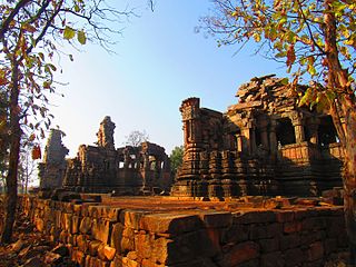
Sanchi Town is a Nagar panchayat, near Raisen town in Raisen District of the state of Madhya Pradesh, India, it is located 46 km (29 mi) north east of Bhopal, and 10 km (6.2 mi) from Besnagar or Vidisha in the central part of the state of Madhya Pradesh. Known for its "Sanchi Stupas", it is the location of several Buddhist monuments dating from the 3rd century BC to the 12th CE and is one of the important places of Buddhist pilgrimage.
Babukhedi is a village in the Bhopal district of Madhya Pradesh, India. It is located in the Berasia tehsil.
Bhatni is a village in the Bhopal district of Madhya Pradesh, India. It is located in the Berasia tehsil.
Mugaliyachhap, also called Mungaliya Chhap, is a village in the Bhopal district of Madhya Pradesh, India. It is located in the Huzur tehsil and the Phanda block.
Pipaliya Dhakad is a village in the Bhopal district of Madhya Pradesh, India. It is located in the Huzur tehsil and the Phanda block.
Samarda, also spelled Samardha, is a village in the Bhopal district of Madhya Pradesh, India. It is located in the Huzur tehsil and the Phanda block.
Sagoni Khurd is a village in the Bhopal district of Madhya Pradesh, India. It is located in the Berasia tehsil.
