John Daniel (ship's captain)

Last updated

John Daniel was an English sea captain who, in the ship New London, charted part of the coast of Western Australia in 1681. Daniel and the New London are believed to have been the second group of English mariners to sight the mainland of Australia, after the Tryall was wrecked in 1620 (and preceding William Dampier's Roebuck, in 1688).

Kingdom of England Historic sovereign kingdom on the British Isles (927–1649; 1660–1707)

The Kingdom of England was a sovereign state on the island of Great Britain from 927, when it emerged from various Anglo-Saxon kingdoms until 1707, when it united with Scotland to form the Kingdom of Great Britain.

Western Australia State in Australia

Western Australia is a state occupying the entire western third of Australia. It is bounded by the Indian Ocean to the north and west, and the Southern Ocean to the south, the Northern Territory to the north-east, and South Australia to the south-east. Western Australia is Australia's largest state, with a total land area of 2,529,875 square kilometres, and the second-largest country subdivision in the world, surpassed only by Russia's Sakha Republic. The state has about 2.6 million inhabitants – around 11 percent of the national total – of whom the vast majority live in the south-west corner, 79 per cent of the population living in the Perth area, leaving the remainder of the state sparsely populated.

Australia Country in Oceania

Australia, officially the Commonwealth of Australia, is a sovereign country comprising the mainland of the Australian continent, the island of Tasmania, and numerous smaller islands. It is the largest country in Oceania and the world's sixth-largest country by total area. The neighbouring countries are Papua New Guinea, Indonesia, and East Timor to the north; the Solomon Islands and Vanuatu to the north-east; and New Zealand to the south-east. The population of 26 million is highly urbanised and heavily concentrated on the eastern seaboard. Australia's capital is Canberra, and its largest city is Sydney. The country's other major metropolitan areas are Melbourne, Brisbane, Perth, and Adelaide.

A surviving copy of Daniel's chart indicates that the "Dangerous Rocks" he sighted was the Wallabi Group; the northernmost islands in the Houtman Abrolhos. A printed copy of Daniel's journal of the voyage has also survived, including a brief description of the islands.

Wallabi Group island group in Western Australia

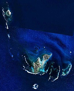
The Wallabi Group is the northern-most group of islands in the Houtman Abrolhos. Nominally located at 28°28′S113°42′E, it is 58 kilometres from the Australian mainland, and about 9 kilometres from the Easter Group.

Houtman Abrolhos archipelago off the west coast of Australia

The Houtman Abrolhos is a chain of 122 islands, and associated coral reefs, in the Indian Ocean off the west coast of Australia. Nominally located at 28°43′S113°47′E, it lies about eighty kilometres (50 mi) west of Geraldton, Western Australia. It is the southernmost true coral reef in the Indian Ocean, and one of the highest latitude reef systems in the world. It is one of the world's most important seabird breeding sites, and is the centre of Western Australia's largest single-species fishery, the western rock lobster fishery. It has a small seasonal population of fishermen, and a limited number of tourists are permitted for day trips, but most of the land area is off limits as conservation habitat. It is well known as the site of numerous shipwrecks, the most famous being the Dutch ships Batavia, which was wrecked in 1629, and Zeewijk, wrecked in 1727.

With the wind S.W. by W. steering by compass N.E. by E. at 10 a.m. the water was discoloured. A man at the foretop saw a breach rise ahead of us. We put our helm hard a starboard...and weathered the N.W. end of it about half a mile...The breach that we first saw happened to be the northernmost of all, there being several and by our computation [they] are 20 miles in length. Within the breaches, several small white sandy islands were seen, with some bushes on them. A very heavy sea broke against the south part of these shoals. When close to them the mainland was not seen. [1]

Daniel also bestowed the name "Maiden's Isle" upon an island that may have been Rottnest Island.

Rottnest Island Western Australia

Rottnest Island is an island off the coast of Western Australia, located 18 kilometres (11 mi) west of Fremantle. A sandy, low-lying island formed on a base of aeolianite limestone, Rottnest is an A-class reserve, the highest level of protection afforded to public land. Together with Garden Island, Rottnest Island is a remnant of Pleistocene dune ridges.

Footnotes

  1. Lee 1934.

Related Research Articles

George Vancouver 18th-century English naval explorer

Captain George Vancouver was a British officer of the Royal Navy best known for his 1791–95 expedition, which explored and charted North America's northwestern Pacific Coast regions, including the coasts of what are now the American states of Alaska, Washington, and Oregon, as well as the province of British Columbia in Canada. He also explored the Hawaiian Islands and the southwest coast of Australia.

James Cook 18th-century British explorer

Captain James Cook was a British explorer, navigator, cartographer, and captain in the Royal Navy. He made detailed maps of Newfoundland prior to making three voyages to the Pacific Ocean, during which he achieved the first recorded European contact with the eastern coastline of Australia and the Hawaiian Islands, and the first recorded circumnavigation of New Zealand.

Atoll Ring-shaped coral reef, generally formed over a subsiding oceanic volcano, with a central lagoon and perhaps islands around the rim

An atoll, sometimes called a coral atoll, is a ring-shaped coral reef including a coral rim that encircles a lagoon partially or completely. There may be coral islands or cays on the rim. The coral of the atoll often sits atop the rim of an extinct seamount or volcano which has eroded or subsided partially beneath the water. The lagoon forms over the volcanic crater or caldera while the higher rim remains above water or at shallow depths that permit the coral to grow and form the reefs. For the atoll to persist, continued erosion or subsidence must be at a rate slow enough to permit reef growth upward and outward to replace the lost height.

Possession Island (Queensland) island of Queensland, Australia

Possession Island is a small island in the Torres Strait Islands group off the coast of far northern Queensland, Australia. It is known as Bedanug or Bedhan Lag by the one of the indigenous Australian inhabitants, the Kaurareg though the Ankamuti were also indigenous to the island.

Torres Strait strait which lies between Australia and the Melanesian island of New Guinea

The Torres Strait is a strait which lies between Australia and the Melanesian island of New Guinea. It is approximately 150 km (93 mi) wide at its narrowest extent. To the south is Cape York Peninsula, the northernmost extremity of the Australian mainland. To the north is the Western Province of Papua New Guinea. It is named after navigator Luís Vaz de Torres, who passed through the Strait in 1606.

John Ross (Royal Navy officer) British naval officer and Arctic explorer

Sir John Ross was a British Royal Navy officer and Polar explorer. He was the uncle of Sir James Clark Ross, who explored the Arctic with him, and later led expeditions to Antarctica.

The human history of Western Australia commenced between 40,000 and 60,000 years ago with the arrival of Indigenous Australians on the northwest coast. The first inhabitants expanded the range of their settlement to the east and south of the continent. The first recorded European contact was in 1616, when Dutch explorer Dirk Hartog landed on the west coast, having been blown off course while en route to Batavia, nowadays called Jakarta.

Edward Bransfield was an Irish sailor who rose to become an officer in the British Royal Navy, serving as a master on several ships, after being impressed into service at the age of 18 in Ireland. He is noted for exploring parts of Antarctica, sighting the Trinity Peninsula in January 1820.

Chukchi Sea A marginal sea of the Arctic Ocean north of the Bering Strait

Chukchi Sea, sometimes referred to as the Chukotsk Sea or the Sea of Chukotsk, is a marginal sea of the Arctic Ocean. It is bounded on the west by the Long Strait, off Wrangel Island, and in the east by Point Barrow, Alaska, beyond which lies the Beaufort Sea. The Bering Strait forms its southernmost limit and connects it to the Bering Sea and the Pacific Ocean. The principal port on the Chukchi Sea is Uelen in Russia. The International Date Line crosses the Chukchi Sea from northwest to southeast. It is displaced eastwards to avoid Wrangel Island as well as the Chukotka Autonomous Okrug on the Russian mainland.

Tweed River (New South Wales) river in Australia

The Tweed River is a river situated in the Northern Rivers district of New South Wales, Australia. It has a mature wave dominated, barrier estuary. From the middle reaches of its course, the state boundary between New South Wales and Queensland is located approximately 10 kilometres (6.2 mi) north of the Tweed River.

Point Hicks point in Australia

Point Hicks or Tolywiarar, is a coastal headland in the East Gippsland region of Victoria, Australia, located within the Croajingolong National Park. The point is marked by the Point Hicks Lighthouse that faces the Tasman Sea.

Matthew Flinders English navigator and cartographer

Captain Matthew Flinders was an English navigator and cartographer who led the second circumnavigation of New Holland that he would subsequently call "Australia or Terra Australis" and identified it as a continent. Abel Tasman had circumnavigated it more widely in 1642-43 and had charted its north coast in 1644.

Tryal Rocks reef in Australia

Tryal Rocks, sometimes spelled Trial Rocks or Tryall Rocks, formerly known as Ritchie's Reef or Greyhound's Shoal, is a reef of rock located in the Indian Ocean off the northwest coast of Australia, 14 kilometres (8.7 mi) northwest of the outer edge of the Montebello Islands group. It is named for the Tryall, the first known shipwreck in Australian waters, which sunk after striking the then-uncharted rocks in 1622. Described as "the theme and dread of every voyager to the eastern islands", their location was sought for over three centuries before finally being determined in 1969.

Mercator Cooper American whaler

Mercator Cooper was a ship's captain who is credited with the first formal American visit to Edo, Japan and the first formal landing on the mainland East Antarctica.

First voyage of James Cook Combined Royal Navy and Royal Society expedition to the south Pacific

The first voyage of James Cook was a combined Royal Navy and Royal Society expedition to the south Pacific Ocean aboard HMS Endeavour, from 1768 to 1771. It was the first of three Pacific voyages of which Cook was the commander. The aims of this first expedition were to observe the 1769 transit of Venus across the Sun, and to seek evidence of the postulated Terra Australis Incognita or "unknown southern land".

Dampier Strait (Papua New Guinea) strait

Dampier Strait in Papua New Guinea separates Umboi Island and New Britain, linking the Bismarck Sea to the north with the Solomon Sea to the south.

Luís Vaz de Torres Portuguese explorer

Luís Vaz de Torres, or Luis Váez de Torres in the Spanish spelling, was a 16th- and 17th-century maritime explorer of a Spanish expedition noted for the first recorded European navigation of the strait which separates the mainland of Australia from the island of New Guinea, and which now bears his name.

Timeline of European exploration timeline

This timeline of European exploration lists major geographic discoveries and other firsts credited to or involving Europeans during the Age of Discovery and the following centuries, between the years AD 1418 and 1957.

2007 Alderney UFO sighting

On 23 April 2007, captain Ray Bowyer was flying a routine passenger flight for the civilian airliner Aurigny Air Services, when he and his passengers gained progressively clearer views of two UFOs during a 12- to 15-minute period. Bowyer had 18 years of flying experience, and the 45-minute flight was one that he had completed every working day for more than 8 years.

The Woppaburra were an indigenous Australian people who lived on Greater and South Keppel islands. They are often considered to be a branch of the Darumbal.

References

Ida Louisa Lee,, historian and poet, was born at Kelso, New South Wales. She was elected a Fellow of the Royal Geographical Society (F.R.G.S.) in 1914 and an Honorary Fellow of the Royal Australian Historical Society. Lee wrote a number of historical texts, some of which contain previously unpublished material.

<i>The Geographical Journal</i> journal

The Geographical Journal is a quarterly peer-reviewed academic journal of the Royal Geographical Society. It publishes papers covering research on all aspects of geography. It also publishes shorter Commentary papers and Review Essays. Since 2001, The Geographical Journal has been published in collaboration with Wiley-Blackwell. The journal was established in 1831 as the Journal of the Royal Geographical Society of London. Prior to 2000, The Geographical Journal published society news alongside articles and it continues to publish the proceedings of the society's annual general meeting and presidential address in the September issue.