Lhotse is the fourth highest mountain in the world at 8,516 metres (27,940 ft), after Mount Everest, K2, and Kangchenjunga. The main summit is on the border between Tibet Autonomous Region of China and the Khumbu region of Nepal.

Cho Oyu is the sixth-highest mountain in the world at 8,188 metres (26,864 ft) above sea level. Cho Oyu means "Turquoise Goddess" in Tibetan. The mountain is the westernmost major peak of the Khumbu sub-section of the Mahalangur Himalaya 20 km west of Mount Everest. The mountain stands on the China Tibet–Nepal Koshi Pradesh border.

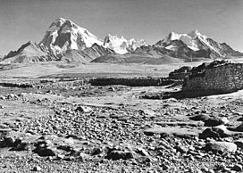
Shishapangma, or Shishasbangma or Xixiabangma, is the 14th-highest mountain in the world, at 8,027 metres (26,335 ft) above sea level. It is located entirely within Tibet. In 1964, it became the final eight-thousander to be climbed.

Chomo Lonzo is a mountain in Tibet, 5 km northeast of Makalu in the Mahalungur (Mohalingor) or Khumbu Himalayas. Alternate spellings of the same name include Chomolonzo, Chomolönzo, Chomo Lönzo, Jomolönzo, and Lhamalangcho.

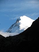
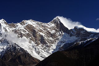
Gangkhar Puensum is the highest mountain in Bhutan and the highest unclimbed mountain in the world, with an elevation of 7,570 metres (24,836 ft) and a prominence of 2,995 metres (9,826 ft). In Dzongkha language, its name means "White Peak of the Three Spiritual Brothers".

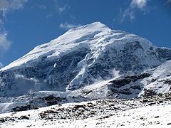
Mount Gongga, also known as Minya Konka and colloquially as "The King of Sichuan Mountains", is the highest mountain in Sichuan province, China. It has an elevation of 7,556 m (24,790 ft) above sea level. This makes it the third highest peak in the world outside of the Himalaya/Karakoram range, after Tirich Mir and Kongur Tagh, and the easternmost and most isolated 7,000-metre (23,000 ft) peak in the world. It is situated in the Daxue Shan mountain range, between Dadu River and Yalong River, and is part of the Hengduan mountainous region. From it comes the Hailuogou glacier.
An unclimbed mountain is a mountain peak that has yet to be climbed to the top. Determining which unclimbed peak is highest is often a matter of controversy. In some parts of the world, surveying and mapping are still unreliable. There are no comprehensive records of the routes of explorers, mountaineers, and local inhabitants. In some cases, even modern ascents by larger parties have been poorly documented and, with no universally recognized listing, the best that can be achieved in determining the world's highest unclimbed peaks is somewhat speculative. Most sources indicate that Gangkhar Puensum on the Bhutan–China border is the tallest mountain in the world that has yet to be fully summited. Gangkhar Puensum has been off limits to climbers since 1994 when Bhutan prohibited all mountaineering above 6,000 m (20,000 ft) due to spiritual/religious beliefs.
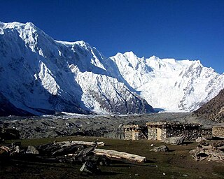
Namcha Barwa or Namchabarwa is a mountain peak lying in Tibet in the region of Pemako. The traditional definition of the Himalaya extending from the Indus River to the Brahmaputra would make it the eastern anchor of the entire mountain chain, and it is the highest peak of its own section as well as Earth's easternmost peak over 7,600 metres (24,900 ft). It lies in the Nyingchi Prefecture of Tibet. It is the highest peak in the 180 km long Namcha Barwa Himal range, which is considered the easternmost syntaxis/section of the Himalaya in southeastern Tibet and northeastern India where the Himalaya are said to end, although high ranges actually continue another 300 km to the east.

The Chumbi Valley, called Dromo or Tromo in Tibetan, is a valley in the Himalayas that projects southwards from the Tibetan plateau, intervening between Sikkim and Bhutan. It is coextensive with the administrative unit Yadong County in the Tibet Autonomous Region of China. The Chumbi Valley is connected to Sikkim to the southwest via the mountain passes of Nathu La and Jelep La.

Gurla Mandhata, also Naimona'nyi or Namu Nani, is the highest peak of the Nalakankar Himal, a small subrange of the Himalaya. It lies in the northwest corner of Nepal. It is the 34th-highest peak in the world. It is also notable for being well within the interior of the Tibetan Plateau and relatively far away from other peaks with heights greater than 7,500 metres. It sits roughly across Lake Manasarovar from the sacred peak of Mount Kailash.
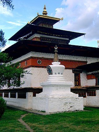
Kyichu Lhakhang, is an important Himalayan Buddhist temple situated in Lango Gewog of Paro Dzongkhag in Bhutan.

Rinpung Dzong, sometimes referred to as Paro Dzong, is a large dzong - Buddhist monastery and fortress - of the Drukpa Lineage of the Kagyu school in Paro District, Bhutan. It houses the district Monastic Body as well as government administrative offices of Paro Dzongkhag. It is listed as a tentative site in Bhutan's Tentative List for UNESCO inclusion.
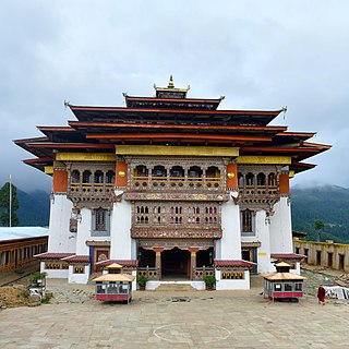
Gangteng Monastery, also known as Gangtey Gonpa or Gangtey Monastery, is a monastery of Nyingmapa school of Tibetan Buddhism, the main seat of the Pema Lingpa tradition, located in the Wangdue Phodrang District in central Bhutan. The monastery, also known by the Gangten village that surrounds it, is in the Phobjikha Valley where winter visitors – the black-necked cranes – visit central Bhutan to roost, circling the monastery three times on arrival and repeating this circling when returning to Tibet. The monastery's history traces to the early 17th century and back to the prophecies made by the terton Pema Lingpa in the late 15th century.

Paro Taktsang, is a sacred Vajrayana Himalayan Buddhist site located in the cliffside of the upper Paro valley in Bhutan. It is one of thirteen Tiger's Nest caves in historical Tibet in which Padmasambhava practiced and taught Vajrayana.

Lingzhi Yügyal Dzong, is an important Drukpa Kagyu monastery and administrative center situated at an altitude of 4150 metres in Lingzhi, Thimphu District, Bhutan. There are about thirty monks headed by a Lama Neten resident in the Dzong. The office of the Drungpa is also housed in the Dzong.
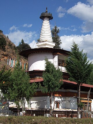
Jangtsa Dumgtseg Lhakhang[zlum brtshegs lha khang] is a Buddhist temple in western Bhutan. The temple is notable as it is in the form of a chorten, very rare in Bhutan. It is located on the edge of a hill between the Paro valley and the Dopchari valley, across the bridge from Paro. The Buddhist iconography depicted in the Chorten is considered a unique repository of the Drukpa Kagyu school.

Chomo Yummo is a 6,829 m (22,405 ft) mountain in the Himalayas on the border between Sikkim in India and Tibet in China.
Chomolhari Kang is a 7046m mountain in the Himalayas in Gasa District, Bhutan near the border with Tibet, China. Quotes on its height vary from 7034m to 7121m, but 7046m is the most common figure. A Chinese crew who first climbed the mountain in 2013 reported a GPS height of 7,054m.

Druk Wangditse Lhakhang("Temple of the Peak of Conquest"),(འབྲུག་དབང་འདུས་རྩེ་ལྷ་ཁང་) is located high on a forested ridge to the south of Tashichho Dzong and overlooks the whole Thimphu valley. It was established in 1715 as the seat of the 8th Druk Desi, Druk Rabgye.