Josephine County, Oregon

Last updated

Josephine County
Josephine County Courthouse - Grants Pass Oregon.jpg
Miller's Chapel (9939448605).jpg
"It's the Climate" sign in Grants Pass, Oregon.jpg
The Wild & Scenic Rogue River (48205898602).jpg
Illinois River State Park (Josephine County, Oregon scenic images) (josDA0086).jpg
From clockwise: Josephine County Courthouse, the "It's the Climate" banner in downtown Grants Pass, Miller's Chapel in the Oregon Caves National Monument, the Rogue River from Hellgate Canyon, Illinois River Forks State Park
Map of Oregon highlighting Josephine County.svg
Location within the U.S. state of Oregon
Oregon in United States.svg
Oregon's location within the U.S.
Coordinates: 42°22′N123°34′W / 42.36°N 123.56°W / 42.36; -123.56
CountryFlag of the United States.svg United States
StateFlag of Oregon.svg  Oregon
FoundedJanuary 22, 1856
Named for Virginia “Josephine” Rollins
Seat Grants Pass
Largest cityGrants Pass
Area
  Total1,642 sq mi (4,250 km2)
  Land1,640 sq mi (4,200 km2)
  Water2.2 sq mi (6 km2)  0.1%
Population
 (2020)
  Total88,090
  Estimate 
(2023)
87,821 Decrease2.svg
  Density50/sq mi (20/km2)
Time zone UTC−8 (Pacific)
  Summer (DST) UTC−7 (PDT)
Congressional district 2nd
Website josephinecounty.gov

Josephine County is one of the 36 counties in the U.S. state of Oregon. As of the 2020 census, the population was 88,090. [1] The county seat is Grants Pass. [2] The county is named after Virginia Josephine Rollins (1834-1912), a settler who was the first white woman to live in the county's boundaries. Josephine County comprises the Grants Pass, OR Metropolitan Statistical Area, which is included in the Medford-Grants Pass, OR Combined Statistical Area.

Contents

History

The discovery of rich placers at Sailor Diggings (later known as Waldo) in 1852 and the resulting gold rush brought the first settlers to this region. Several U.S. Army forts were maintained in the county and many engagements during the Rogue River Indian War (1855–1858) took place within its boundaries. In 1851, a group of prospectors moved to the Illinois Valley and made the first discovery of gold in Southern Oregon. In this group was Floyd Rollins and his daughter, Josephine Rollins Ort, after whom the county is named. [3] On January 22, 1856, a bill was passed by the territorial legislature separating what is now Josephine County from Jackson County. The bill made Sailor Diggings (later known as Waldo) the county seat. [4] It was the nineteenth, and last, county created before statehood.[ citation needed ]

In 1885, the county seat was relocated to Kerby, where the county's first jail was built. [5] In 1885, the Oregon Legislature adjusted the boundary between Jackson and Josephine County, making Grants Pass a part of Josephine County. This was done primarily to have a railroad head within the new county. [6] In June 1886 the voters of Josephine County considered three towns for the new county seat. These were: Kerby, Wilderville and Grants Pass. Grants Pass won with 116 votes out of the 716 ballots cast. [6] [7]

In the 1920s, the county improved its tourist facilities. [8] In 1922, the Grants Pass Cavemen booster club was created, where members dressed in furs and wielded clubs at events. Events organized by the club ranged from simply blocking traffic, to bidding on the construction of the San Francisco–Oakland Bay Bridge (at a cost of 23,756,000 deer hides), to initiating politicians into their club including Mark Hatfield and Thomas E. Dewey during his 1948 presidential campaign. Russian newspapers used images of the Grants Pass Cavemen to show 'how the rich "cavort" in America.' [9] Although bridges had been built across the Rogue River by the 1920s, ferries were still used to convey people and cars across. The first Grants Pass bridge was destroyed by a flood in 1890. [10] The first newspaper in Josephine County was the Argus, which began publication on March 13, 1885. It lasted only a few months, but the Grants Pass Courier began three weeks later. [11] The Illinois Valley News published in Cave Junction started in 1937 and is still a paper of record in Josephine County publishing every Wednesday. In 1897, the first legal hanging took place in Josephine County. Lemson W. Melson [12] confessed to the murder of Charles Perry while the noose was around his neck. [13]

Ethnic history

Although several tribes of Native Americans lived in the area from which Josephine County was created, most of their members had been moved to the reservation at Grand Ronde by the end of the Rogue River Indian War. Soon afterwards all Indians in southwest Oregon, with the exception of a few small bands, were moved to the Coast reservation (later known as the Siletz Reservation). [7]

Josephine County was also the home to a large Chinese population. Most had come to the area to work gold claims purchased from whites no longer interested in working them. Even though they could not own land, they had to pay a tax to mine gold, and were usually relegated to inferior claims.[ citation needed ]

Geography

Map of Josephine County Josephine County.svg
Map of Josephine County

According to the United States Census Bureau, the county has a total

area of 1,642 square miles (4,250 km2), of which 1,640 square miles (4,200 km2) is land and 2.2 square miles (5.7 km2) (0.1%) is water. [14]

Adjacent counties

National protected areas

Demographics

Historical population
CensusPop.Note
1860 1,623
1870 1,204−25.8%
1880 2,485106.4%
1890 4,87896.3%
1900 7,51754.1%
1910 9,56727.3%
1920 7,655−20.0%
1930 11,49850.2%
1940 16,30141.8%
1950 26,54262.8%
1960 29,91712.7%
1970 35,74619.5%
1980 58,85564.6%
1990 62,6496.4%
2000 75,72620.9%
2010 82,7139.2%
2020 88,0906.5%
2023 (est.)87,821 [15] −0.3%
U.S. Decennial Census [16]
1790–1960 [17] 1900–1990 [18]
1990–2000 [19] 2010–2020 [1]

2000 census

As of the 2000 census, there were 75,726 people, 31,000 households, and 21,359 families residing in the county. The population density was 46 people per square mile (18 people/km2). There were 33,239 housing units at an average density of 20 units per square mile (7.7/km2). The racial makeup of the county was 93.90% White, 0.27% Black or African American, 1.25% Native American, 0.63% Asian, 0.11% Pacific Islander, 1.17% from other races, and 2.68% from two or more races. 4.26% of the population were Hispanic or Latino of any race. 18.5% were of German, 14.3% English, 10.4% Irish and 9.3% American ancestry according to Census 2000. 95.6% spoke English and 2.8% Spanish as their first language.

There were 31,000 households, out of which 26.90% had children under the age of 18 living with them, 54.40% were married couples living together, 10.40% had a female householder with no husband present, and 31.10% were non-families. 25.40% of all households were made up of individuals, and 12.10% had someone living alone who was 65 years of age or older. The average household size was 2.41 and the average family size was 2.85.

In the county, the population was spread out, with 23.10% under the age of 18, 6.50% from 18 to 24, 23.20% from 25 to 44, 27.20% from 45 to 64, and 20.10% who were 65 years of age or older. The median age was 43 years. For every 100 females there were 94.60 males. For every 100 females age 18 and over, there were 91.10 males.

The median income for a household in the county was $31,229, and the median income for a family was $36,894. Males had a median income of $30,798 versus $22,734 for females. The per capita income for the county was $17,234. About 11.30% of families and 15.00% of the population were below the poverty line, including 21.10% of those under age 18 and 6.80% of those age 65 or over.

2010 census

As of the 2010 census, there were 82,713 people, 34,646 households, and 22,498 families residing in the county. [20] The population density was 50.4 inhabitants per square mile (19.5/km2). There were 38,001 housing units at an average density of 23.2 units per square mile (9.0 units/km2). [21] The racial makeup of the county was 92.4% white, 1.4% American Indian, 0.8% Asian, 0.4% black or African American, 0.2% Pacific islander, 1.5% from other races, and 3.2% from two or more races. Those of Hispanic or Latino origin made up 6.3% of the population. [20] In terms of ancestry, 26.3% were German, 15.6% were Irish, 15.5% were English, 5.5% were Italian, and 5.5% were American. [22]

Of the 34,646 households, 25.5% had children under the age of 18 living with them, 49.2% were married couples living together, 11.0% had a female householder with no husband present, 35.1% were non-families, and 28.3% of all households were made up of individuals. The average household size was 2.34 and the average family size was 2.82. The median age was 47.3 years. [20]

The median income for a household in the county was $38,035 and the median income for a family was $48,180. Males had a median income of $38,675 versus $27,926 for females. The per capita income for the county was $21,539. About 13.5% of families and 17.8% of the population were below the poverty line, including 27.3% of those under age 18 and 9.1% of those age 65 or over. [23]

Communities

Cities

Census-designated places

Unincorporated communities

Economy

Most of the commercial activity during the territorial period centered on gold mining and the supply of provisions to miners. Miners had been active in the Rogue and Illinois valleys since 1851. By the late 1850s, however, gold mining was beginning to decline and population dwindled as well. In 1859, gold was discovered along the Fraser River in British Columbia and numerous people left Josephine County to search for valuable claims there.

Josephine County shares the Rogue Valley and Applegate Valley wine appellations with Jackson County. The U.S. government owns the majority of the land within the county boundaries, with the Bureau of Land Management owning 28% of the lands within the county boundaries, most of which are Oregon and California Railroad lands, and the Forest Service owning 39%.

Grants Pass is now the departure point for most Rogue River scenic waterway guided fishing and boat trips, one of the destinations being Hellgate canyon. The Illinois River, one of the Rogue's tributaries, has also been designated a scenic waterway.

Transportation

Initially, freight was brought into Josephine County by pack train. As the trails improved, freight wagons were used. Stage coaches were the primary mode of transportation until 1914, when auto stages took over, halving the time from Crescent City to Grants Pass from 24 to 12 hours. [24]

In 1883, the Oregon and California Railroad reached Grants Pass, in Jackson County at the time. [25] The first through train from Portland, Oregon arrived in Grants Pass on Christmas Eve of 1883. Due to delays in completing a railroad through the Siskiyou Mountains, the first train from California didn't arrive until 1887. Josephine County was served by the Oregon and California Railroad. [26] In 1923, commercial flight in Josephine County began when airplanes began taking off from the American Legion Air Field. The airfield has since been replaced by an industrial park. [27]

Politics

Josephine County has been among the most consistently Republican counties in Oregon with regard to presidential elections. In 1964, it was along with Malheur County one of two Oregon counties to give a majority to Barry Goldwater. [28] This is the county in Oregon to have gone the longest without voting for a Democrat in a presidential election; the last Democratic candidate to win the county was Franklin D. Roosevelt in 1936, [29] and the solitary Democrat since 1900 to win an absolute majority was Roosevelt in 1932 (though, in 1916, the county was won by Charles Evans Hughes by just four votes). Prior to the 1890s, Josephine was a generally Democratic county as the Rogue Valley and adjacent areas, like the San Joaquin Valley in California, had considerable anti-Union sympathies. [30]

As of 2023, Josephine County lies within Oregon's 2nd congressional district, which is represented by the Republican Congressman Cliff Bentz. In the Oregon House of Representatives, Josephine County is split between two districts. A portion in the northeast is in the 4th District (extending into Douglas and Jackson counties), represented by Republican Christine Goodwin. The majority of Josephine County, including the core of Grants Pass, lies within the 3rd District represented by Republican Lily Morgan. The whole of Josephine County is within Oregon's 2nd Senate District, represented by Republican Art Robinson.

In 2004 Democrat Dennis Kucinich spoke publicly while campaigning in Josephine County, making appearances in both Grants Pass and Cave Junction. Robert Kennedy made a campaign stop in Grants Pass in late May 1968 at the conclusion of a whistle stop campaign tour by train originating in Portland. Kennedy spoke to a crowd of several hundred in a supermarket parking lot on the site of the former Southern Pacific passenger station which had been demolished some years previously just a week before his assassination in California on June 5, 1968. [31]

United States presidential election results for Josephine County, Oregon [32]
Year Republican Democratic Third party
No.%No.%No.%
2020 31,75161.48%18,45135.73%1,4392.79%
2016 26,92360.42%13,45330.19%4,1849.39%
2012 23,67358.83%14,95337.16%1,6124.01%
2008 22,97354.63%17,41241.41%1,6643.96%
2004 26,24162.07%15,21435.99%8201.94%
2000 22,18660.40%11,86432.30%2,6837.30%
1996 16,04849.98%11,11334.61%4,95015.42%
1992 13,00338.75%11,00732.80%9,54928.45%
1988 15,87658.21%10,64639.04%7502.75%
1984 19,47069.38%8,53930.43%530.19%
1980 16,82763.89%7,11627.02%2,3939.09%
1976 10,72650.81%9,06142.92%1,3236.27%
1972 9,91158.55%5,09030.07%1,92611.38%
1968 8,45657.64%4,35129.66%1,86412.71%
1964 6,91850.13%6,85749.68%260.19%
1960 7,38757.57%5,41942.23%250.19%
1956 7,96762.10%4,86337.90%00.00%
1952 8,20070.36%3,35328.77%1020.88%
1948 5,00458.27%3,29038.31%2943.42%
1944 4,01054.52%3,21443.70%1311.78%
1940 3,96457.18%2,88841.66%801.15%
1936 1,99233.45%2,84047.69%1,12318.86%
1932 1,75733.80%3,06058.87%3817.33%
1928 2,62571.31%95926.05%972.64%
1924 1,75653.91%65019.96%85126.13%
1920 1,60662.22%81931.73%1566.04%
1916 1,66046.20%1,65646.09%2777.71%
1912 30513.68%70231.48%1,22354.84%
1908 96747.47%73235.94%33816.59%
1904 91460.89%32721.79%26017.32%

Libraries

In May 2007, all libraries in Josephine County were closed due to lack of county government funding. In September 2007, committed community members formed Josephine Community Libraries, Inc., a nonprofit, nongovernmental organization. On December 20, 2008, the Grants Pass library opened again. On September 5, 2009, the Illinois Valley library was reopened. On November 7, 2009, the Williams library was reopened. With the reopening of the Wolf Creek branch on December 19, 2009, all four library branches in Josephine County were restored. Josephine Community Libraries, Inc. (JCLI) is a nonprofit, nongovernmental library system serving the 82,000 residents of Josephine County. In May 2017, citizens placed a measure on the ballot to permanently fund the libraries, which passed by 53 percent of the vote. For 10 years, the libraries were supported by generous donations and the heroic contributions of more than 360 volunteers annually. Now, JCLI is committed to a seamless transition of library services to the newly formed library district and is working to support the district effort until the anticipated transition is completed in 2018. [33]

See also

Related Research Articles

<span class="mw-page-title-main">Washington County, Oregon</span> County in Oregon, United States

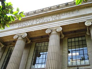
Washington County is one of 36 counties in the U.S. state of Oregon and part of the Portland metropolitan area. The 2020 census recorded the population as 600,372, making it the second most populous county in the state and most populous "Washington County" in the United States. Hillsboro is the county seat and largest city, while other major cities include Beaverton, Tigard, Cornelius, Banks, Gaston, Sherwood, North Plains, and Forest Grove, the county's oldest city. Originally named Twality when created in 1843, the Oregon Territorial Legislature renamed it for the nation's first president in 1849 and included the entire northwest corner of Oregon before new counties were created in 1854. The Tualatin River and its drainage basin lie almost entirely within the county, which shares its boundaries with the Tualatin Valley. It is bordered on the west and north by the Northern Oregon Coast Range, on the south by the Chehalem Mountains, and on the north and east by the Tualatin Mountains, or West Hills.

<span class="mw-page-title-main">Wahkiakum County, Washington</span> County in Washington, United States

Wahkiakum County is a county located in the U.S. state of Washington. As of the 2020 census, the population was 4,422, making it one of least populous counties in Washington. The county seat and only incorporated town is Cathlamet. The county was formed out of Cowlitz County in April 1854 and is named for Chief Wahkiakum of the Chinook, who is buried in the Pioneer Cemetery in Cathlamet.

<span class="mw-page-title-main">Yamhill County, Oregon</span> County in Oregon, United States

Yamhill County is one of the 36 counties in the U.S. state of Oregon. As of the 2020 census, the population was 107,722. The county seat is McMinnville. Yamhill County was named after the Yamhelas, members of the Kalapuya Tribe.

<span class="mw-page-title-main">Wheeler County, Oregon</span> County in Oregon, United States

Wheeler County is a county in the U.S. state of Oregon. As of the 2020 census, the population was 1,451, making it Oregon's least populous county. It is named in honor of Henry H. Wheeler. an early settler who owned a farm near Mitchell. The county seat is Fossil, and Wheeler County is known for having Oregon's largest deposit of fossils.

<span class="mw-page-title-main">Wasco County, Oregon</span> County in Oregon, United States

Wasco County is one of the 36 counties in the U.S. state of Oregon. As of the 2020 census, the population was 25,213. Its county seat is The Dalles. The county is named for a local tribe of Native Americans, the Wasco, a Chinook tribe who live on the south side of the Columbia River. It is near the Washington state line. Wasco County comprises The Dalles Micropolitan Statistical Area.

<span class="mw-page-title-main">Union County, Oregon</span> County in Oregon, United States

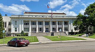
Union County is one of the 36 counties in the U.S. state of Oregon, and one of the 8 counties of eastern Oregon. As of the 2020 census, the population was 26,196. The county comprises the La Grande micropolitan statistical area and the county seat is La Grande.

<span class="mw-page-title-main">Polk County, Oregon</span> County in Oregon, United States

Polk County is one of the 36 counties in the U.S. state of Oregon. As of the 2020 census, the population was 87,433. The county seat is Dallas. The county is named for James Knox Polk, the 11th president of the United States.

<span class="mw-page-title-main">Linn County, Oregon</span> County in Oregon, United States

Linn County is one of the 36 counties in the U.S. state of Oregon. As of the 2020 census, the population was 128,610. The county seat is Albany. The county is named in the honor of Lewis F. Linn, a U.S. Senator from Missouri who advocated the American settlement of the Oregon Country. Linn County comprises the Albany, OR Metropolitan Statistical Area, which is included in the Portland-Vancouver-Salem, OR-WA Combined Statistical Area. It is located in the Willamette Valley. In 2010, the center of population of Oregon was located in Linn County, near the city of Lyons.

<span class="mw-page-title-main">Klamath County, Oregon</span> County in Oregon, United States

Klamath County is one of the 36 counties in the U.S. state of Oregon. As of the 2020 census, the population was 69,413. The county seat is Klamath Falls. The county was named for the Klamath, the tribe of Native Americans living in the area at the time the first European explorers entered the region. Klamath County comprises the Klamath Falls, OR Micropolitan Statistical Area.

<span class="mw-page-title-main">Jackson County, Oregon</span> County in Oregon, United States

Jackson County is one of the 36 counties in the U.S. state of Oregon. As of the 2020 census, the population was 223,259. The county seat is Medford. The county is named for Andrew Jackson, the seventh president of the United States.

<span class="mw-page-title-main">Gilliam County, Oregon</span> County in Oregon, United States

Gilliam County is one of the 36 counties in the U.S. state of Oregon. As of the 2020 census, the population was 1,995, making it the third-least populous county in Oregon. The county seat is Condon. The county was established in 1885 and is named for Cornelius Gilliam, a colonel who commanded the forces of the provisional government of Oregon after the Whitman Massacre.

<span class="mw-page-title-main">Douglas County, Oregon</span> County in Oregon, United States

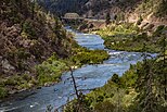
Douglas County is one of the 36 counties in the U.S. state of Oregon. As of the 2020 census, the population was 111,201. The county seat is Roseburg. The county is named after Stephen A. Douglas, an American politician who supported Oregon statehood. Douglas County comprises the Roseburg, OR Micropolitan Statistical Area. In regards to area, Douglas County is the largest county west of the Oregon Cascades.

<span class="mw-page-title-main">Curry County, Oregon</span> County in Oregon, United States

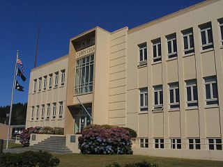
Curry County is the southwesternmost county in the U.S. state of Oregon located on the South Coast. As of the 2020 census, the population was 23,446. The county seat is Gold Beach. The county is named for George Law Curry, a two-time governor of the Oregon Territory. Curry County includes the Brookings, OR Micropolitan Statistical Area.

<span class="mw-page-title-main">Benton County, Oregon</span> County in Oregon, United States

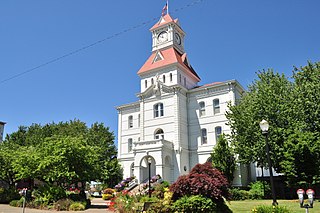
Benton County is one of the 36 counties in the U.S. state of Oregon. As of the 2020 census, the population was 95,184. Its county seat is Corvallis. The county was named after Thomas Hart Benton, a U.S. Senator who advocated American control over the Oregon Country. Benton County is designated as the Corvallis, OR Metropolitan Statistical Area, which is included in the Portland–Vancouver–Salem, OR–WA Combined Statistical Area. It is in the Willamette Valley.

<span class="mw-page-title-main">Baker County, Oregon</span> County in Oregon, United States

Baker County is one of the 36 counties in the U.S. state of Oregon. As of the 2020 census, the population was 16,668. The county seat and largest city is Baker City. The county was organized on September 22, 1862, when a portion of Wasco County was partitioned off. The new county's area was reduced in 1864 when Union County was partitioned off, and again in 1887 when Malheur County was partitioned off. The county's lines were last adjusted in 1901 when a parcel was added to the county.

<span class="mw-page-title-main">Grant County, New Mexico</span> County in New Mexico, United States

Grant County is a county located in the U.S. state of New Mexico. At the 2020 census, the population was 28,185. Its county seat is Silver City. The county was founded in 1868 and named for Ulysses S. Grant, the 18th President of the United States.

<span class="mw-page-title-main">Central Point, Oregon</span> City in Oregon, United States

Central Point is a city in Jackson County, Oregon, United States. The population was 17,169 as of 2010. The city shares its southern border with Medford and is a part of the Medford metropolitan area. Central Point is home of the Jackson County Fair that occurs in July.

<span class="mw-page-title-main">Rogue River, Oregon</span> City in Oregon, United States

Rogue River is a city in Jackson County, Oregon, United States. As of the 2020 census the population was 2,407.

<span class="mw-page-title-main">Grants Pass, Oregon</span> City in Oregon, United States

Grants Pass is a city in and the county seat of Josephine County, Oregon, United States. The city is located on Interstate 5, northwest of Medford, along the Rogue River. The population is 39,194 according to the 2020 census, making it the 15th most populous city in Oregon.

<span class="mw-page-title-main">Redwood, Oregon</span> Unincorporated community in the state of Oregon, United States

Redwood is a census-designated place (CDP) in Josephine County, Oregon, United States. The population was 2,627 at the 2010 census, down from 5,844 at the 2000 census as it has lost territory to the neighboring city of Grants Pass.

References

  1. 1 2 "State & County QuickFacts". United States Census Bureau. Retrieved May 15, 2023.
  2. "Find a County". National Association of Counties. Archived from the original on May 31, 2011. Retrieved June 7, 2011.
  3. Sutton, p. 6.
  4. Sutton, p. 10.
  5. Sutton, pp. 15-17.
  6. 1 2 Sutton, p. 18.
  7. 1 2 Edna May Hill (1976). "Josephine County Historical Highlights". Josephine County Library System & Josephine County Historical Society. pp. 73, 74.
  8. Sutton, p. 65.
  9. Sutton, pp. 59-61.
  10. Sutton, pp. 59-74.
  11. Sutton, pp. 59-76-78.
  12. https://www.oregongeology.org/milo/archive/HistoricalSociety/Josephine/GrantsPassCourier1937Section2Newspaper.pdf [ bare URL PDF ]
  13. Sutton, pp. 59-79.
  14. "2010 Census Gazetteer Files". United States Census Bureau. August 22, 2012. Retrieved February 26, 2015.
  15. "Annual Estimates of the Resident Population for Counties: April 1, 2020 to July 1, 2023". United States Census Bureau. Retrieved March 24, 2024.
  16. "U.S. Decennial Census". United States Census Bureau. Retrieved February 26, 2015.
  17. "Historical Census Browser". University of Virginia Library. Retrieved February 26, 2015.
  18. Forstall, Richard L., ed. (March 27, 1995). "Population of Counties by Decennial Census: 1900 to 1990". United States Census Bureau. Retrieved February 26, 2015.
  19. "Census 2000 PHC-T-4. Ranking Tables for Counties: 1990 and 2000" (PDF). United States Census Bureau. April 2, 2001. Archived from the original (PDF) on February 26, 2015. Retrieved February 26, 2015.
  20. 1 2 3 "DP-1 Profile of General Population and Housing Characteristics: 2010 Demographic Profile Data". United States Census Bureau. Archived from the original on February 13, 2020. Retrieved February 23, 2016.
  21. "Population, Housing Units, Area, and Density: 2010 - County". United States Census Bureau. Archived from the original on February 13, 2020. Retrieved February 23, 2016.
  22. "DP02 SELECTED SOCIAL CHARACTERISTICS IN THE UNITED STATES – 2006-2010 American Community Survey 5-Year Estimates". United States Census Bureau. Archived from the original on February 13, 2020. Retrieved February 23, 2016.
  23. "DP03 SELECTED ECONOMIC CHARACTERISTICS – 2006-2010 American Community Survey 5-Year Estimates". United States Census Bureau. Archived from the original on February 13, 2020. Retrieved February 23, 2016.
  24. Sutton, pp. 86.
  25. Sutton, p. 201.
  26. Sutton, pp. 92-94.
  27. Sutton, pp. 99.
  28. David Leip Presidential Election Atlas
  29. Geographie Electorale
  30. Menendez, Albert J.; The Geography of Presidential Elections in the United States, 1868-2004, pp. 284-286 ISBN   0786422173
  31. Archived at Ghostarchive and the Wayback Machine : Oregon Collegiate Broadcast System. "Oregon 1968 - RFK Campaign Train". Youtube. R.W. Rynerson. Retrieved June 5, 2016.
  32. Leip, David. "Dave Leip's Atlas of U.S. Presidential Elections". uselectionatlas.org. Retrieved April 11, 2018.
  33. "Josephine Community Libraries" . Retrieved June 7, 2010.
General

42°22′N123°34′W / 42.36°N 123.56°W / 42.36; -123.56