
Hudson Strait links the Atlantic Ocean and Labrador Sea to Hudson Bay in Canada. This strait lies between Baffin Island and Nunavik, with its eastern entrance marked by Cape Chidley in Newfoundland and Labrador and Resolution Island off Baffin Island. The strait is about 750 km long with an average width of 125 km, varying from 70 km at the eastern entrance to 240 km at Deception Bay.

The Gulf of St. Lawrence is the outlet of the North American Great Lakes via the St. Lawrence River into the Atlantic Ocean. The gulf is a semi-enclosed sea, covering an area of about 226,000 square kilometres (87,000 sq mi) and containing about 34,500 cubic kilometres (8,300 cu mi) of water, which results in an average depth of 152 metres (499 ft).

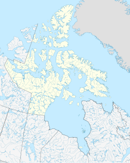
The Arctic Archipelago, also known as the Canadian Arctic Archipelago, is an archipelago lying to the north of the Canadian continental mainland, excluding Greenland.

The Mid-Atlantic Ridge is a mid-ocean ridge located along the floor of the Atlantic Ocean, and part of the longest mountain range in the world. In the North Atlantic, the ridge separates the North American from the Eurasian Plate and the African Plate, north and south of the Azores Triple Junction respectively. In the South Atlantic, it separates the African and South American plates. The ridge extends from a junction with the Gakkel Ridge northeast of Greenland southward to the Bouvet Triple Junction in the South Atlantic. Although the Mid-Atlantic Ridge is mostly an underwater feature, portions of it have enough elevation to extend above sea level, for example in Iceland. The ridge has an average spreading rate of about 2.5 centimetres (1 in) per year.

Unorganized North Algoma District is an unorganized area in northeastern Ontario, Canada, comprising all areas in Algoma District, north of the Sault Ste. Marie to Elliot Lake corridor, which are not part of an incorporated municipality or a First Nation. It covers 44,077.03 km2 (17,018.24 sq mi) of land, and had a population of 5739 in 2016.
Leoville is a Canadian rural community located on Route 158, 3.50–5.00 miles SW of Tignish in western Prince County, Prince Edward Island.

Ordas is a village and municipality in Bács-Kiskun county, in the Southern Great Plain region of southern Hungary.

Tignish-Palmer Road is a provincial electoral district for the Legislative Assembly of Prince Edward Island, Canada. It was formerly Tignish-DeBlois from 1996 to 2007.
Berry Mills is a small, unincorporated community north-west of Moncton, New Brunswick. It is located around the main Canadian National Railway line, which was formerly the Intercolonial Railway of Canada line. Major Intersections include New Brunswick Route 128 and New Brunswick Route 2 as well as Homestead Road and New Brunswick Route 128. Berry Mills also includes the mostly forest area of Lutesville, New Brunswick.
Murchison Promontory, a cape (promontory) in the northern Canadian Arctic, is the northernmost mainland point of the Americas and of Canada. Located 1,087 nautical miles from the North Pole, it is 64 km (40 mi) farther north than Point Barrow, Alaska, the northernmost point of all U.S. territory.
Brooklyn may refer to one of two unincorporated settlements in Prince Edward Island, Canada:
Helena College University of Montana is a public community college in Helena, Montana. It was established in 1939 and was previously known as The University of Montana – Helena College of Technology, Helena College of Technology, and the Helena Vocational-Technical Center. The school offers associate degrees in arts, science, and applied science as well as technical proficiency certificates in various fields.

The Church of St. Jude, located at 3815 Tenth Avenue at the corner of West 205th Street in the Inwood neighborhood of Manhattan, New York City, is a Catholic parish church in the Archdiocese of New York. Established in 1949, the current sanctuary was built in 1975-76 and was designed by Clark & Warren in the Brutalist style. The School of St. Jude, located around the corner at 431 West 204th Street and built in 1949–51 to designs by Voorhees, Walker, Foley & Smith, was originally the sanctuary as well. A two-story rectory at 411-445 West 204th Street was built in 1957 to designs by architect P. Goodman.
Skrugar Point is a peninsula in Qikiqtaaluk Region, Nunavut, Canada. It is located on Amund Ringnes Island 40 miles (64 km) northwest of Cape Southwest. It rises to 290 metres (950 ft) above sea level and forms an entrance point to Sand Bay.
German submarine U-292 was a Type VIIC/41 U-boat of Nazi Germany's Kriegsmarine during World War II.
This page is based on this
Wikipedia article Text is available under the
CC BY-SA 4.0 license; additional terms may apply.
Images, videos and audio are available under their respective licenses.
