Kōnosu-shuku

Last updated
Keisai Eisen's print of Konosu-shuku, part of the Sixty-nine Stations of the Kiso Kaido series Kisokaido07 Konosu.jpg
Keisai Eisen's print of Kōnosu-shuku, part of the Sixty-nine Stations of the Kiso Kaidō series

Kōnosu-shuku(鴻巣宿,Kōnosu-shuku) was the seventh of the sixty-nine stations of the Nakasendō highway connecting Edo with Kyoto during the Edo period. It was located in the present-day city of Kōnosu, Saitama Prefecture, Japan.

69 Stations of the Nakasendō

The 69 Stations of the Nakasendō are the rest areas along the Nakasendō, which ran from Nihonbashi in Edo to Sanjō Ōhashi in Kyoto. The route stretched approximately 534 km (332 mi) and was an alternate trade route to the Tōkaidō.

Nakasendō

The Nakasendō, also called the Kisokaidō (木曾街道), was one of the five routes of the Edo period, and one of the two that connected Edo to Kyoto in Japan. There were 69 stations (staging-posts) between Edo and Kyoto, crossing through Musashi, Kōzuke, Shinano, Mino and Ōmi provinces. In addition to Tokyo and Kyoto, the Nakasendō runs through the modern-day prefectures of Saitama, Gunma, Nagano, Gifu and Shiga, with a total distance of about 534 km (332 mi).

Edo Former city in Musashi, Japan

Edo, also romanized as Jedo, Yedo or Yeddo, is the former name of Tokyo. It was the seat of power for the Tokugawa shogunate, which ruled Japan from 1603 to 1868. During this period, it grew to become one of the largest cities in the world and home to an urban culture centered on the notion of a "floating world".

Contents

History

The original Kōnosu-shuku was located in what is now the city of Kitamoto; however, when the system of post stations on the Nakasendō was formalized by the Tokugawa shogunate in 1602, the post station relocated to the north to its current location. The new location was approximately 18 ri, 8-chō from the starting point of the Nakasendō at Nihonbashi, or approximately 48 kilometers. It was 16.4 kilometers from Kumagai-shuku and 7.2 kilometers from the following Okegawa-juku. Due to the distance between Kōnosu-shuku and Kumagai-shuku, an ai no shuku , Fukiage-shuku was located in-between.

Kitamoto, Saitama City in Kantō, Japan

Kitamoto is a city in Saitama Prefecture, Japan. As of 1 February 2016, the city had an estimated population of 67,319, and a population density of 3400 persons per km². Its total area is 19.82 square kilometres (7.65 sq mi).

<i>Shukuba</i> post stations of Japan in the Edo period

Shukuba (宿場) were post stations during the Edo period in Japan, generally located on one of the Edo Five Routes or one of its sub-routes. They were also called shuku-eki (宿駅). These post stations were places where travelers could rest on their journey around the nation. They were created based on policies for the transportation of goods by horseback that were developed during the Nara and Heian periods.

Tokugawa shogunate Last feudal Japanese military government which existed between 1600 and 1868

The Tokugawa Shogunate, also known as the Tokugawa Bakufu (徳川幕府) and the Edo Bakufu (江戸幕府), was the last feudal Japanese military government, which existed between 1603 and 1867. The head of government was the shōgun, and each was a member of the Tokugawa clan. The Tokugawa shogunate ruled from Edo Castle and the years of the shogunate became known as the Edo period. This time is also called the Tokugawa period or pre-modern.

The reason for the move is unclear today, but in its new location the Nakasendō was not the only road running through Kōnosu-shuku. It also had roads connecting to Matsuyama (present-day Higashimatsuyama), Nin (present-day Gyōda), and Kisaichi (present-day Kisai). Most of the post station burned down in a fire in 1767, but was soon rebuilt.

Higashimatsuyama, Saitama City in Kantō, Japan

Higashimatsuyama is a city located in Saitama Prefecture, Japan. As of 1 February 2016, the city had an estimated population of 91,520, with a population density of 1,400 persons per km². The total area is 65.33 km2 (25.22 sq mi).

Kisai, Saitama Former municipality in Kantō, Japan

Kisai was a town located in Kitasaitama District, Saitama Prefecture, Japan.

Monument to the location of the honjin of Konosu-shuku Monument of the Konosu-juku on the Nakasendo.jpg
Monument to the location of the honjin of Kōnosu-shuku

Per an 1843 guidebook issued by the Inspector of Highways(道中奉行,Dōchu-būgyō), the town stretched for about 1.9 kilometers along the highway, with a population of 2274 in 556 houses, and boasted one honjin , one waki-honjin, one tonya and 58 hatago .

<i>Honjin</i>

Honjin (本陣) is the Japanese word for an inn for government officials, generally located in post stations (shukuba) during the later part of the Edo period.

Hatago (旅籠) were Edo period lodgings for travelers at shukuba along the national highways, including the Edo Five Routes and the subroutes. In addition to a place to rest, hatago also offered meals and other foods to the travelers. They were also called hatagoya (旅籠屋).

At the entrance to the post station is Shōgan-ji, a large temple in the Jōdoshū sect. [1] T

Pure Land Buddhism A school of Mahāyāna Buddhism

Pure Land Buddhism, also referred to as Amidism in English, is a broad branch of Mahayana Buddhism and one of the most widely practiced traditions of Buddhism in East Asia. Pure Land is a tradition of Buddhist teachings that are focused on the Buddha Amitābha. The three primary texts of the tradition, known as the "Three Pure Land Sutras", are the Longer Sukhāvatīvyūha Sūtra, Amitayurdhyana Sutra and the Shorter Sukhāvatīvyūha Sūtra.

Kōnosu-shuku in The Sixty-nine Stations of the Kiso Kaidō

Keisai Eisen's ukiyo-e print of Kōnosu-shuku dates from 1835–1838. The print does now actually show the post station at all, but a landscape with a zig-zag road presumably between Kōnosu and Kumagaya, dominated by a large snow-capped Mount Fuji in the background. In the foreground is a "komusō" mendicant monk with a distinctive straw hat, and a porter heading in the opposite direction with a "kiseru" Japanese smoking pipe. Four other travelers are on the road, hearing in the direction of Mount Haruna and Mount Akagi.

Keisai Eisen Japanese ukiyo-e woodblock print artist

Keisai Eisen was a Japanese ukiyo-e artist who specialised in bijin-ga. His best works, including his ōkubi-e, are considered to be masterpieces of the "decadent" Bunsei Era (1818–1830). He was also known as Ikeda Eisen, and wrote under the name of Ippitsuan.

Ukiyo-e A genre of Japanese art which flourished from the 17th through 19th centuries

Ukiyo-e is a genre of Japanese art which flourished from the 17th through 19th centuries. Its artists produced woodblock prints and paintings of such subjects as female beauties; kabuki actors and sumo wrestlers; scenes from history and folk tales; travel scenes and landscapes; flora and fauna; and erotica. The term ukiyo-e (浮世絵) translates as "picture[s] of the floating world".

Mount Fuji Volcano in Yamanashi and Shizuoka Prefectures, Japan

Mount Fuji, located on Honshū, is the highest volcano in Japan at 3,776.24 m (12,389 ft), 2nd-highest peak of an island (volcanic) in Asia, and 7th-highest peak of an island in the world. It is a dormant stratovolcano that last erupted in 1707–1708. Mount Fuji lies about 100 kilometers (60 mi) south-west of Tokyo, and can be seen from there on a clear day. Mount Fuji's exceptionally symmetrical cone, which is snow-capped for about 5 months a year, is a well-known symbol of Japan and it is frequently depicted in art and photographs, as well as visited by sightseers and climbers.

Neighboring post towns

Nakasendō
Okegawa-shuku - Kōnosu-shuku – (Fukiage-shuku) - Kumagai-shuku

Related Research Articles

Kōnosu City in Kantō, Japan

Kōnosu is a city located in Saitama Prefecture, Japan. As of 1 February 2016, the city had an estimated population of 118,087, and a population density of 1750 persons per km². Its total area is 67.44 square kilometres.

Ageo-shuku

Ageo-shuku was the fifth of the sixty-nine stations of the Nakasendō highway connecting Edo with Kyoto during the Edo period. It was located in the present-day city of Ageo, Saitama Prefecture, Japan.

Shiojiri-shuku

Shiojiri-shuku was the thirtieth of the sixty-nine stations of the Nakasendō. It is located in the central part of the present-day city of Shiojiri, Nagano Prefecture, Japan.

Shimosuwa-shuku

Shimosuwa-shuku was the twenty-ninth of the sixty-nine stations of the Nakasendō, as well as being the ending location of the Kōshū Kaidō. It is located in the present-day town of Shimosuwa, Suwa District, Nagano Prefecture, Japan.

Warabi-shuku

Warabi-shuku was the second of the sixty-nine stations of the Nakasendō highway connecting Edo with Kyoto during the Edo period. It was located in the present-day city of Warabi, Saitama Prefecture, Japan.

Wada-shuku

Wada-shuku was the twenty-eighth of the sixty-nine stations of the Nakasendō highway connecting Edo with Kyoto during the Edo period. It was located in the present-day town of Nagawa, in the Chiisagata District of Nagano Prefecture, Japan.

Nagakubo-shuku

Nagakubo-shuku was the twenty-seventh of the sixty-nine stations of the Nakasendō highway connecting Edo with Kyoto during the Edo period. It is located in the present-day town of Nagawa, in the Chiisagata District of Nagano Prefecture, Japan.

Iwamurada-shuku

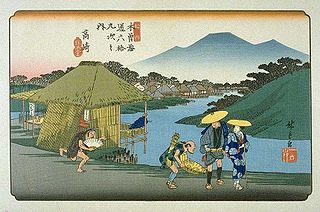
Iwamurada-shuku was the twenty-second of the sixty-nine stations of the Nakasendō. It is located in the present-day city of Saku, in Nagano Prefecture, Japan.

Kumagai-shuku

Kumagai-shuku was the eighth of the sixty-nine stations of the Nakasendō highway connecting Edo with Kyoto during the Edo period. It was located in the present-day city of Kuamagaya, Saitama Prefecture, Japan.

Oiwake-shuku

Oiwake-shuku was the twentieth of the sixty-nine stations of the Nakasendō. It is located in the present-day town of Karuizawa, in the Kitasaku District of Nagano Prefecture, Japan.

Fukaya-shuku

Fukaya-shuku was the ninth of the sixty-nine stations of the Nakasendō highway connecting Edo with Kyoto during the Edo period It was located in the present-day city of Fukaya, Saitama Prefecture, Japan.

Honjō-shuku

Honjō-shuku was the tenth of the sixty-nine stations of the Nakasendō highway connecting Edo with Kyoto during the Edo period. It was the largest of the stations in terms of population and number of buildings. It was located in the present-day city of Honjō, Saitama Prefecture, Japan.

Okegawa-shuku

Okegawa-shuku was the sixth of the sixty-nine stations of the Nakasendō highway connecting Edo with Kyoto during the Edo period. It was located in the present-day city of Okegawa, Saitama Prefecture, Japan.

Kuragano-shuku

Kuragano-shuku was the twelfth of the sixty-nine stations of the Nakasendō. It is located in the present-day city of Takasaki, Gunma Prefecture, Japan.

Takasaki-shuku

Takasaki-shuku was the thirteenth of the sixty-nine stations of the Nakasendō. It is located in the present-day city of Takasaki, Gunma Prefecture, Japan.

Ai no Shuku were unofficial post stations along historical routes in Japan. These post stations formed organically along routes when the distance between two places was too far or when there were difficult passes nearby. Because they were not officially designated rest areas, travelers along the roads were not allowed to stay in these post stations. Sometimes the Japanese is shortened to 間宿.

<i>The Sixty-nine Stations of the Kiso Kaidō</i>

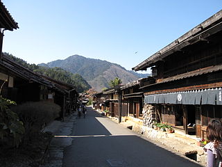
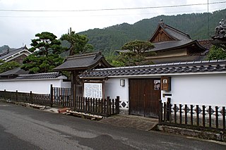
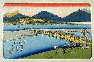
The Sixty-nine Stations of the Kiso Kaidō or Sixty-nine Stations of the Kiso Road, is a series of ukiyo-e works created by Utagawa Hiroshige and Keisai Eisen. There are 71 total prints in the series. The common name for the Kiso Kaidō is "Nakasendō," so this series is sometimes referred to as the Sixty-nine Stations of the Nakasendō. It is a follow up to Hiroshige's The Fifty-three Stations of the Tōkaidō and he produced 47 of the prints, with Eisen being responsible for the rest.

Fukiage-shuku

Fukiage-shuku was a mid-station along the Nakasendō in Edo period Japan. It was in between the post stations of Kōnosu-juku and Kumagai-juku. It is located in the present-day town of Kōnosu, Saitama Prefecture, Japan. In addition to being a rest stop along the Nakasendō, it was also an officially designated post station on the Nikkō Wakiōkan.

References

Izzard, Sebastian (2008). The Sixty-Nine Stations of the Kisokaido. George Braziller. ISBN   0807615935.

Notes

  1. Kōnosu-shi Kankō Mapppu Archived 2005-03-17 at the Wayback Machine .. Kōnosu Tourist Association. Accessed August 27, 2007.

Coordinates: 36°03′32.83″N139°30′48.63″E / 36.0591194°N 139.5135083°E / 36.0591194; 139.5135083