
Articles about people, places, things, and concepts related to or originating from Fiji, include:
The House of Chiefs in Fiji consists of the Fijian nobility, composed of about seventy chiefs of various ranks, majority of which are related. It is not a formal political body and is not the same as the former Great Council of Chiefs, which was a political body with a prescribed constitutional role, although the membership of the two bodies did overlap to a great extent.
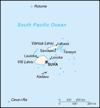
Kadavu, with an area of 411 square kilometres (159 sq mi), is the fourth largest island in Fiji, and the largest island in the Kadavu Group, a volcanic archipelago consisting of Kadavu, Ono, Galoa and a number of smaller islands in the Great Astrolabe Reef. Its main administrative centre is Vunisea, which has an airport, a high school, a hospital, and a government station, on the Namalata Isthmus where the island is almost cut in two. Suva, Fiji's capital, lies 88 kilometres to the north of Kadavu. The population of the island province was 10,167 at the most recent census in 2007.
Burebasaga is the largest of the three confederacies that make up Fiji's House of Chiefs, to which some of the Fijian chiefs belong.
Sir James Michael Ah Koy,, is a Fijian businessman, politician, and diplomat. He is Executive Chairman of Kelton Investments, the IT service provider Datec Group Ltd., Honorary Consul of the Republic of Georgia to Fiji and a board director of forty-six companies. He served as a Cabinet Minister in the 1990s, and was a Senator from 2001 to 2006. He is Fiji's past ambassador to China. He served until December 2010, and was replaced by Esala Teleni.
Naming conventions in Fiji differ greatly, both between and within ethnic groups in Fiji. Indigenous Fijians have a set of cultural practices which today are more loosely followed, and to some extent blended with elements of European culture with regard to names. In the Indian community, traditional Indian naming practices co-exist with influence from the Fijian and European cultures.
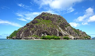
Ono Island is a member of the Kadavu Group, an outlier to Kadavu Island, to the south of Viti Levu, one of Fiji's two main islands. It is separated from Kadavu Island by the Ono Channel. Located at 18.88° South and 178.50° East, this volcanic island is enclosed by the Great Astrolabe Reef. It covers an area of 30 square kilometers. Its maximum altitude is 354 meters. There are seven villages: Vabea (south), Waisomo (south), Narikoso (southeast), Naqara (northeast), Nabouwalu (northwest), Buliya, Dravuni.

Bau is a small island in Fiji, off the east coast of the main island of Viti Levu. Bau rose to prominence in the mid-1800s and became Fiji's dominant power; until its cession to Britain, it has maintained its influence in politics and leadership right through to modern Fiji.

Moala is a volcanic island in the Moala subgroup of Fiji's Lau archipelago. It has an area of 62.5 square kilometers (24.1 sq mi), making it the ninth largest island of Fiji. The highest point on the island of Moala, at a maximum elevation of 468 meters (1,535 ft), is called Delaimoala which has rich vegetation and consists of dark thick forest. The population of around 3000 live in eight villages. The chief village of Naroi, whose population is over 500, was formalised during the colonial era to entertain those that would not be entertained elsewhere. Economic activities include coconut farming, cocoa production, fishing and yaqona (kava) production.
Naitasiri is one of the 14 provinces of Fiji and one of eight located on Viti Levu, Fiji's largest island.
Ra is one of the fourteen provinces of Fiji. Occupying the northern area of Viti Levu, the largest island, it is one of eight Viti Levu-based Provinces. With a land area of 1,341 square kilometers, it had a population of 30,432 in 2017 census. The main urban centre is at Vaileka, with a population of 3,361 in 1996.

Tailevu is one of the 14 provinces of Fiji. Its capital town is Nausori which lies along the banks of the Rewa River.
Bulou is a title used by Fijian women of chiefly rank, in the Provinces of Nadroga-Navosa and Kadavu, and parts of Serua Province, in Fiji.

Lomaloma is a village at the south of the island of Vanua Balavu in the Lau archipelago of Fiji. The settlement is part of the tribal district of Tikina, Lomaloma and consists of 9 villages, 13 Yavusa (tribes), 42 Mataqali (clans), and 54 family units known as Tokatoka. The nine villages of Lomaloma Tikina are Lomaloma, Sawana, Susui, Narocivo, Namalata, Uruone, Levukana, Dakuilomaloma, and Tuvuca.
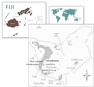
Turaga na Rasau is a traditional Fijian chiefly title of the Lau Islands. Prior to Fiji's colonial days, Fiji had many different Vanua with their own Paramount Chieftain which exercised no authority over the other; a saying from the island of Kadavu aptly summarises it "Nomu Turaga o sega na noqu Turaga" or "Your Chief is not my Chief" also the people of Beqa Island were of a similar opinion saying "Qali Cuva Ki Lagi" or "Subject only to heaven" and would bow to no outside Chieftain, but at the turn of the 20th century aspects of the traditional social structure remained, but for administrative purposes three main Matanitu were solidified and formed as they were the dominant consolidated powers at the time being that of Kubuna, Burebasaga and Tovata. With regard to the Rasau while its traditional origins were in Kubuna on Bau the titles traditional authority in modern Fiji is now in Tovata, Lau in particular Lomaloma Tikina on the Island of Vanua Balavu.

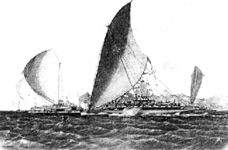
The Lasakau Sea Warriors were a 19th-century warrior sub-culture in the pre-colonial state of Bau, in Fiji. The sea warriors were instrumental in spreading Bau's political power throughout the South Pacific archipelagic islands. The rise of the eminent islet of Bau amongst other embryonic states was due mainly to the projection of sea power through its naval forces. Bauan chief Ratu Loaloadravu Tubuanakoro was praised by French Captain Dumont D'Urville in May 1827 for his geographic knowledge of the Fijian archipelago signifying Bau's naval influence. More far-ranging than Bau's land warriors led by the Vusaradave clan, the Lasakau clan became the leading proponents of war and tribute for the emerging island kingdom. They became known as the Bai kei Bau or 'War fence of Bau'. Sahlins made the crucial observation that," The kings of Bau based their rule not on native cultivators but on native sailors and fishers-which is to say in Fijian categories, as in political strategies, not on the land but on the sea". This was the great political transformation that catapulted Bau to power over other pre-colonial kingdoms.
Lelean Memorial School is the largest school in Fiji. It was established in 1943 and is run by the Methodist Church of Fiji and Rotuma. It is co-located at the Davuilevu Methodist Compound with the Davuilevu Theological College and the Young People's Department, which runs training for Methodist catechists.

Navatu is a sub district in Cakaudrove; one of 3 provinces situated in Vanua Levu, the second largest island in Fiji. The sub-district, or "tikina" as it is known in the iTaukei language, comprises nine villages mainly occupying the eastern peninsular of the Natewa Bay. While Copra has been the main source of income for villages in the Navatu tikina, kava or yaqona is also becoming a fast growing commodity for villages within the Navatu sub-district.