Petropavlovsk-Kamchatsky is a city and the administrative center of Kamchatka Krai, Russia. It is located in the far east of the country and lies along the coast of Avacha Bay by the Pacific Ocean. As of the 2021 census, it had a population of 164,900.

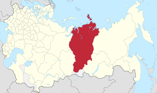
Irkutsk Oblast is a federal subject of Russia, located in southeastern Siberia in the basins of the Angara, Lena, and Nizhnyaya Tunguska Rivers. The administrative center is the city of Irkutsk. It borders the Republic of Buryatia and the Tuva Republic in the south and southwest, which separate it from Khövsgöl Province in Mongolia; Krasnoyarsk Krai in the west; the Sakha Republic in the northeast; and Zabaykalsky Krai in the east. It had a population of 2,370,102 at the 2021 Census.

Chukotka, officially the Chukotka Autonomous Okrug, is the easternmost federal subject of Russia. It is an autonomous okrug situated in the Russian Far East, and shares a border with the Republic of Sakha to the west, Magadan Oblast to the south-west, and Kamchatka Krai to the south, as well as a maritime border on the Bering Strait with the U.S. state of Alaska to the east. Anadyr is the largest town and the capital, and the easternmost settlement to have town status in Russia.

The KamchatkaPeninsula is a 1,250-kilometre-long (777 mi) peninsula in the Russian Far East, with an area of about 270,000 km2 (104,248 sq mi). The Pacific Ocean and the Sea of Okhotsk make up the peninsula's eastern and western coastlines, respectively. Immediately offshore along the Pacific coast of the peninsula runs the 10,500-metre-deep (34,449 ft) Kuril–Kamchatka Trench.

The modern administrative-territorial structure of Russia is a system of territorial organization which is a product of a centuries-long evolution and reforms.

Anadyr is a port town and the administrative center of Chukotka Autonomous Okrug, Russia, located at the mouth of the Anadyr River at the tip of a peninsula that protrudes into Anadyrsky Liman. Anadyr is the easternmost town in Russia; more easterly settlements, such as Provideniya and Uelen, do not have town status. It was previously known as Novo–Mariinsk.

Primorskaya Oblast was an administrative division of the Russian Empire and the early Russian SFSR, created on October 31, 1856 by the Governing Senate. The name of the region literally means "Maritime" or "Coastal." The region was established upon a Russian conquest of Daur people that used to live along Amur River. Before the Russian conquest of Russian Manchuria, the territory belonged to the Chinese region of Manchuria.

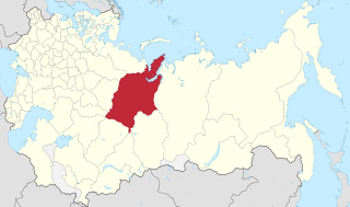
Kamchatka Krai is a federal subject of Russia, situated in the Russian Far East. It is administratively part of the Far Eastern Federal District. Its administrative center and largest city is Petropavlovsk-Kamchatsky, home to over half of its population of 291,705.

The Kherson Governorate, known until 1803 as the Nikolayev Governorate, was a province (guberniya) of the Russian Empire, with its centеr in Kherson. The governorate encompassed 71,936 square kilometres (27,775 sq mi) in area and had a population of 2,733,612 inhabitants. At the time of the census in 1897, it bordered the Podolia Governorate to the northwest, the Kiev Governorate to the north, the Poltava Governorate to the northeast, the Yekaterinoslav Governorate to the east, the Taurida Governorate to the southeast, the Black Sea to the south, and the Bessarabia Governorate to the west. It roughly corresponds to what is now most of Mykolaiv, Kirovohrad and Odesa Oblasts and some parts of Kherson and Dnipropetrovsk Oblasts.

The Yekaterinoslav Governorate, also known by Ukrainian common name Katerynoslavshchyna, was a governorate of the Russian Empire, with its capital located in Yekaterinoslav. The governorate covered 63,392 square kilometres (24,476 sq mi) of area, and was composed of the inhabitant of 2,113,674 by the census of 1897. The Yekaterinoslav Governorate bordered the Poltava Governorate to the north, the Don Host Oblast to the east, the Sea of Azov to the southeast, the Taurida Governorate to the south, and the Kherson Governorate to the east, and covered the area of the Luhansk, Donetsk, Dnipropetrovsk, and Zaporizhzhia Oblasts of Ukraine.

The Extreme North or Far North is a large part of Russia located mainly north of the Arctic Circle and boasting enormous mineral and natural resources. Its total area is about 5,500,000 square kilometres (2,100,000 sq mi), comprising about one-third of Russia's total area. Formally, the regions of the Extreme North comprise the whole of Chukotka Autonomous Okrug, Kamchatka Krai, Magadan Oblast, Murmansk Oblast and Sakha, as well as certain parts and cities of Arkhangelsk Oblast, Irkutsk Oblast, Khabarovsk Krai, Komi Republic, Krasnoyarsk Krai, Republic of Karelia, Sakhalin Oblast, Tuva, Tyumen Oblast, as well as all islands of the Arctic Ocean, its seas, the Bering Sea, and the Sea of Okhotsk.

Novgorod Governorate was an administrative division of the Russian Empire and the Russian SFSR, which existed from 1727 to 1776 and from 1796 to 1927. Its administrative center was in the city of Novgorod. The governorate was located in the northwest of the European part of the Russian Empire.
Yeniseysk Governorate was a governorate (guberniya) of the Russian Empire and later of the Russian Republic, Russian Socialist Federative Soviet Republic in 1822-1925.

Vologda Governorate, also known as the Government of Vologda, was an administrative division of the Russian Empire and the Russian SFSR, which existed from 1796 until 1929. Its administrative center was in the city of Vologda. The governorate was located in the north of Russian Empire.

Arkhangelsk Governorate was an administrative division of the Russian Empire and Russian SFSR, which existed from 1796 until 1929. Its seat was in Arkhangelsk. The governorate was located in the north of the Russian Empire and bordered Tobolsk Governorate in the east, Vologda Governorate in the south, Olonets Governorate in the southwest, Sweden in the west, and Norway in north-west. In the north, the governorate was limited by the White and Barents Seas.
Tobolsk Governorate was an administrative division of the Russian Empire, Russian Republic and RSFSR located in the Ural Mountains and Siberia. It existed from 1796 to 1920; its seat was in the city of Tobolsk, in 1919–1920 in the city of Tyumen.
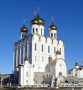
The Diocese of Magadan and Sinegorye is an eparchy of the Russian Orthodox Church. The Eparchy Cathedral is the Holy Trinity Cathedral in Magadan.

Tver Governorate was an administrative division of the Russian Empire and Russian SFSR, which existed from 1796 until 1929. Its seat was in Tver. The governorate was located in the center of the European part of the Russian Empire and bordered Novgorod Governorate in the north, Yaroslavl Governorate in the east, Vladimir Governorate in the southeast, Moscow Governorate in the south, Smolensk Governorate in the southwest, and Pskov Governorate in the west.
Saratov Governorate, was an administrative division of the Russian Empire and the Russian Socialist Federative Soviet Republic, which existed from 1797 to 1928. Its administrative center was in the city of Saratov.
The Military Governor was the highest government and military official in a Governorate or Oblast, who was also the commander of troops in his area in the Russian Empire until 1917.