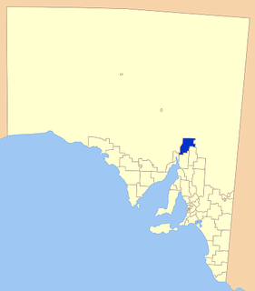
Flinders Ranges Council is a local government area (LGA) located in the Flinders Ranges of South Australia.

Simmonston was a former town in South Australia which was abandoned before completion in the early 1880s. The town was originally intended to be on the new railway extending north from Quorn, but the final route passed through Gordon instead. Today, the stone ruins of a hotel and its cellars are still visible. The town is reported as being "named after Sir Lintorn Simmons, Field Marshal and Commandant of the Royal Engineers" by William Jervois, the 10th Governor of South Australia. The creation of the town was announced in April 1880 as follows: "Portions of Crown Lands in the Hundred of Kanyaka have been reserved as a site for the new town of Simmonston." Plans to build the hotel were announced three weeks later in May 1880 by a D. McFie. The site of the former town is currently located in the gazetted locality of Kanyaka and within the local government area of the Flinders Ranges Council.
Edward Nowell Twopeny was an Australian politician who represented the South Australian House of Assembly multi-member seat of Newcastle from 1917 to 1918, representing the Liberal Union.

The District Council of Woolundunga was a local government area in South Australia from 1888 until 1933.
The District Council of Wilmington was a local government area in South Australia, centred on the town of Wilmington from 1888 to 1980.
The District Council of Hawker was a local government area in South Australia from 1888 to 1997, centred on the town of Hawker. At its creation it was the northernmost local government area in the state.

The Corporate Town of Quorn was a local government area in South Australia from 1883 to 1969, centred on the town of Quorn.
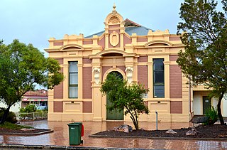
The Quorn Town Hall is a heritage-listed former town hall at 20 Railway Terrace, Quorn, South Australia. It was added to the South Australian Heritage Register on 12 January 1984; it is also listed on the Register of the National Estate.

Kanyaka is a rural locality in the Far North region of South Australia, situated in the Flinders Ranges Council.
The Hundred of Boolcunda is a cadastral hundred of the County of Newcastle in South Australia. It was proclaimed by Governor Anthony Musgrave in 1876.

The County of Newcastle is one of the 49 counties of South Australia spanning the central Flinders Ranges. It was named in 1876 for Francis Pelham-Clinton-Hope, the eighth Duke of Newcastle.

The Hundred of Wonoka is a cadastral unit of hundred in the County of Blachford, South Australia.
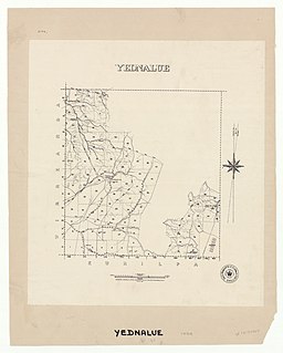
The Hundred of Yednalue is a cadastral unit of hundred in the County of Granville, South Australia.

The Hundred of Wirreanda is a cadastral unit of hundred in the County of Granville, South Australia. The township of Cradock is at the hundred's centre.

The County of Frome is one of the 49 cadastral counties of South Australia in straddling the Mid North and Flinders Ranges regions. It was proclaimed in 1851 by Governor Henry Young and was named for the former Surveyor-General of South Australia, Edward Charles Frome. The iconic Mount Remarkable in the Hundred of Gregory is at the centre of the county.

The County of Granville is one of the 49 counties of South Australia located in the Flinders Ranges region. It was proclaimed in 1876 by Governor Anthony Musgrave and was named for the Granville Leveson-Gower, the second Earl of Granville and the Secretary of State for the Colonies until a few years prior.
This page is based on this
Wikipedia article Text is available under the
CC BY-SA 4.0 license; additional terms may apply.
Images, videos and audio are available under their respective licenses.