Albania is a small country in Southern, Southeastern Europe and Western Balkans strategically positioned on the Adriatic and Ionian Sea inside the Mediterranean Sea, with a coastline of about 476 km (296 mi). It is bounded by Montenegro to the northwest, Kosovo to the northeast, North Macedonia to the east and Greece to the southeast and south.

Sazan is an island inside the Mediterranean Sea in southern Albania. It is the largest island in Albania and strategically located between the Strait of Otranto and the entrance to the Bay of Vlorë, forming the border between the Adriatic and Ionian Sea. The island has a surface area of 5.7 km2 (2.2 sq mi) with a length of 4.8 km (3.0 mi), width of 2 km (1.2 mi) and a coastline of about 15 km (9.3 mi).

Mali i Thatë is a mountain in southeast Albania; with a part of it being in the southwest of North Macedonia with the highest altitude of 2287 meters. It borders Lake Prespa in the east, Lake Ohrid in northwest and overlooks the city of Pogradec to the west. It stretches 25 km from north to south and is 8 km wide in its central part. Mali i Thatë highest peak is Pllaja e Pusit and it reaches an altitude of 2,287 m (7,503 ft) above sea level. It is found within Albania, close to the Macedonian border. From this high peak, among several mountains of Albania, both Ohrid Lake and Prespa Lake can be seen as well as the third highest peak in North Macedonia, Baba Mountain or Pelister Mountain. The mountain has an anticlinal shape and is almost completely composed of mesozoic limestone formations. Mali i Thatë has craggy slopes, whereas its crest is almost flat but full of karstic cavities.
Karmel Kandreva was an Arbëresh writer and poet.

Finiq is a predominantly Greek-inhabited settlement, considered town or village, and municipality in Vlorë County, in southern Albania located 8 km from the Ionian Sea and 20 km north of the Greek border. It was formed at the 2015 local government reform by the merger of the former municipalities Aliko, Dhivër, Finiq, Livadhja and Mesopotam, that became municipal units. The seat of the municipality is the village Dermish. The total population is 10,529, in a total area of 444.28 km2.

Lenie(Aromanian: Stãvinerea) is a village and a former municipality in the Elbasan County, in central Albania. At the 2015 local government reform it became a subdivision of the municipality Gramsh. The population at the 2011 census was 779. It comprises six villages:
Stillo Island or Stil Island is a small island in the southernmost tip coastline of Vlorë County, Albania.

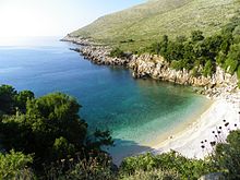
The Ceraunian Mountains, also commonly Akroceraunian Mountains, are a coastal mountain range in southwestern Albania, within the county of Vlorë. The range rises on the northeastern bank of the Ionian Sea. It extends for approximately 100 km (62 mi) in a southeast-northwest direction near Sarandë along the Albanian Riviera nearby to Orikum. Geologically, the Karaburun Peninsula belongs to the mountain range, forming the eastern Akroceraunian Mountains. The mountains are about 24 km (15 mi) long and about 4–7 km (2.5–4.3 mi) wide.

The Llogara National Park is a national park centered on the Ceraunian Mountains along the Albanian Riviera in Southwestern Albania, spanning an surface area of 1,010 ha (10.1 km2). The park's terrain includes large alpine meadows, vertical rock faces, precipices and dense forests. The most area of land is covered by forests and was established in 1966 to protect several ecosystems and biodiversity of national importance. The International Union for Conservation of Nature (IUCN) has listed the park as Category II. The region has been recognised as an important Bird and Plant Area, because it support significant numbers of various bird and plant species.

The Bay of Vlorë is a large bay of the Adriatic Sea situated along the Albanian Adriatic Sea Coast on the Mediterranean Sea in Southern Europe. It opens to the sea in the northwest and is largely surrounded by the lagoon of Narta in the north, the city of Vlorë in the northeast, the mountains of the Ceraunians in the east and southeast, and the peninsula of Karaburun in the southwest and west.
Alush bey Frakulla was an Albanian leader, known for his role in the uprisings of 1835 and 1837. During the latter, he was captured together with 150 of his men and was punished with hard labor in Ottoman prisons, where he died in unknown date.
The Cape of Gjuhëz is a rocky cape northwest of Karaburun Peninsula as well as the westernmost point of continental Albania. It projects 1.1 kilometres (0.68 mi) into the sea in the form of the tongue, thus the origin of its name. The altitudes of the cape slope gradually towards the water, whereas the southern shores form 30 to 40 metres high steep cliffs that fall directly to the Ionian sea. The cape lacks vegetation, while limestone rocks, highly eroded by Karst are spread over whole the area.
The Karaburun-Sazan Marine Park is a marine park in the Vlorë County of southwestern Albania. The marine park encompasses over 125.70 km2 (48.53 sq mi) and comprises the boundaries of both the Peninsula of Karaburun and the Island of Sazan. It is home to a vast array of landforms, including mountains, caves, islands, depressions, bays, cliffs, canyons and rocky coasts, all contributing to an exceptionally considerable biological diversity. The marine park has been identified as an Important Bird and Plant Area, because it supports immense bird and plant species. Containing ecosystems and habitats that are specific to the Mediterranean Basin, the convention of Barcelona has classified the marine park as a Specially Protected Areas of Mediterranean Importance.

Maja e Thatë is a 2,406-metre-high (7,894 ft) mountain peak of the Albanian Alps (Prokletije) in Albania. It is located within Valbonë Valley National Park, roughly 2 km (1 mi) northwest of Valbonë and rises more than 1,500 m (4,921 ft) above the village. The mountain's southern and western lower slopes are relatively rich in beech and pine forests, while the higher slopes consist of very steep dolomite and limestone rock walls, suitable for mountaineering and rock climbing.
Vlado was a nobleman in the service of the Serbian kingdom, with the title of kaznac. According to Milan Šufflay he was from the Matjan tribe (Матесеи/Matesei), a former Byzantine stratiot who became kaznac of the Serbian kingdom between 1274 and 1279. He has been identified with the kaznac "Blenisti", who together with his brother Viljem, Jovan Musaki and Dimitar Sok were imprisoned in Apulia in 1279 due to leading a rebellion in Albania. They were imprisoned as traitors to Angevin rule. He is believed to have been the progenitor of the Blinishti family active in northern Albania.

For a small country, Albania is characterised by a considerable wealth of terrestrial and marine ecosystems and habitats with contrasting floral and faunal species, defined in an area of 28,748 square kilometres. Most of the country is predominantly of Mediterranean character, comprehending the country's center and south, while the alpine affinity is more visible in the northeast.
The Albanian Ionian Sea Coast is a coastline of the Northeastern Ionian Sea, that encompasses the southwestern border of the Republic of Albania, stretching from the southern half of Karaburun Peninsula, across the historical region of Labëria, the city of Sarandë, the mountains of the Ceraunians and the Albanian Riviera, to the Lake of Butrint, where the Strait of Corfu separates the country from Greece.

The Cave of Haxhi Ali is a karst cave formed in limestone cliffs in southwestern Albania, located in the Karaburun Peninsula near the Cape of Gjuhëz in Vlorë County. The cave was named after Haxhi Aliu, a prominent Albanian warrior and sailor from Ulcinj who fled with his son in this cave. Several archaeological objects has been found, that prove that this cave was used by traders and passers during the ancient times. The cave has a length of 30 m (98 ft) with a width which can vary between of 10–12 m (33–39 ft) and a height of 18 m (59 ft).

The Bay of Grama is a bay in the Ionian Sea situated along the Albanian Ionian Sea Coast on the Mediterranean Sea in Southern Europe. It is one of many bays of the western Ceraunian Mountains along the Albanian Riviera south of the Karaburun Peninsula.
Hadji Alia or Haxhi Aliu Ulqinaku (1569–1625) was an Albanian pirate lord from Ulcinj, originating from Calabria.