
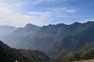
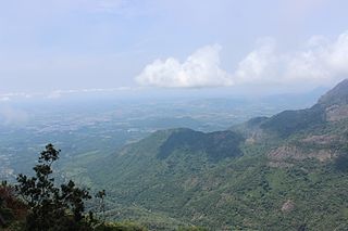
The Western Ghats, also known as the Sahyadri mountain range, is a mountain range that covers an area of 160,000 km2 (62,000 sq mi) in a stretch of 1,600 km (990 mi) parallel to the western coast of the Indian peninsula, traversing the states of Gujarat, Maharashtra, Goa, Karnataka, Kerala and Tamil Nadu. It is a UNESCO World Heritage Site and one of the 36 biodiversity hotspots in the world. It is sometimes called the Great Escarpment of India. It contains a very large proportion of the country's flora and fauna, many of which are endemic to this region. The Western Ghats are older than the Himalayas. They influence Indian monsoon weather patterns by intercepting the rain-laden monsoon winds that sweep in from the south-west during late summer. The range runs north to south along the western edge of the Deccan Plateau and separates the plateau from a narrow coastal plain called the Western Coastal Plains along the Arabian Sea. A total of 39 areas in the Western Ghats, including national parks, wildlife sanctuaries and reserve forests, were designated as world heritage sites in 2012 – twenty of them in Kerala, ten in Karnataka, six in Tamil Nadu and four in Maharashtra.
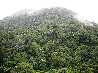
The South Western Ghats montane rain forests is an ecoregion in South India, covering the southern portion of the Western Ghats in Karnataka, Kerala and Tamil Nadu at elevations from 1,000 to 2,695 m. Annual rainfall in this ecoregion exceeds 2,800 mm (110 in).
Nilambur is a major town, a municipality and a Taluk in the Malappuram district of the Indian state of Kerala. It is located close to the Nilgiris range of the Western Ghats on the banks of the Chaliyar River. This place is also known as 'Teak Town' because of the abundance of Nilambur teaks in this area; Which is a variety of a large, deciduous tree that occurs in mixed hardwood forests. Unlike many Municipalities of India; Nilambur is covered with large amounts of vegetation making it close to nature and hence make it very scenic and inspiring.

The South Western Ghats moist deciduous forests is an ecoregion in the Western Ghats of southern India with tropical and subtropical moist broadleaf forests. This biome covers the Nilgiri Hills between elevation of 250 and 1,000 m in Kerala, Karnataka and Tamil Nadu states.
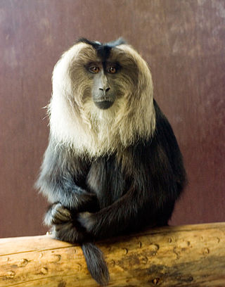
The lion-tailed macaque, also known as the wanderoo, is an Old World monkey endemic to the Western Ghats of South India.
Silent Valley National Park is a national park in Kerala, India. It is located in the Nilgiri hills and has a core area of 89.52 km2 (34.56 sq mi). It is surrounded by a buffer zone of 148 km2 (57 sq mi). This national park has some rare species of flora and fauna. Silent Valley National Park was explored in 1847 by the botanist Robert Wight. It is located in the border of Mannarkkad Taluk of Palakkad district, Nilambur Taluk of Malappuram district, Kerala, and Nilgiris district of Tamil Nadu.
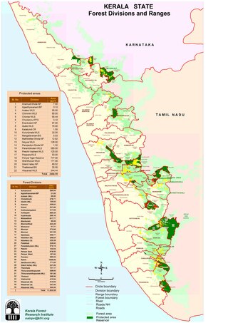
The Nilgiri Biosphere Reserve is a biosphere reserve in the Nilgiri Mountains of the Western Ghats in South India. It is the largest protected forest area in India, spreading across Tamil Nadu, Karnataka and Kerala. It includes the protected areas Mudumalai National Park, Mukurthi National Park, Sathyamangalam Wildlife Sanctuary in Tamil Nadu; Nagarhole National Park, Bandipur National Park, both in Karnataka; Silent Valley National Park, Aralam Wildlife Sanctuary, Wayanad Wildlife Sanctuary, and Karimpuzha Wildlife Sanctuary in Kerala.
The term Malabar rainforests refers to one or more distinct ecoregions recognized by biogeographers:
- the Malabar Coast moist forests formerly occupied the coastal zone to the 250 metre elevation
- the South Western Ghats moist deciduous forests grow at intermediate elevations
- the South Western Ghats montane rain forests cover the areas above 1000 metres elevation

Periyar National Park and Wildlife Sanctuary (PNP) is a protected area located in the districts of Idukki and Pathanamthitta in Kerala, India. It is notable as an elephant reserve and a tiger reserve. The protected area encompasses 925 km2 (357 sq mi), of which 305 km2 (118 sq mi) of the core zone was declared as the Periyar National Park in 1982. The park is a repository of rare, endemic, and endangered flora and fauna and forms the major watershed of two important rivers of Kerala: the Periyar and the Pamba.

Mukurthi National Park (MNP) is a 78.46 km2 (30.3 sq mi) protected area located in the western corner of the Nilgiris Plateau west of Ootacamund hill station in the northwest corner of Tamil Nadu state in the Western Ghats mountain range of South India. The park was created to protect its keystone species, the Nilgiri tahr.

Mannarkkad, formerly known as Mannarghat, is a major municipal town in Palakkad district of the Indian state of Kerala. The Silent Valley National Park and the Attappadi Reserve Forest are located in Mannarkkad Taluk. Mannarkkad is situated 36 km away from district headquarters Palakkad on National Highway 966.
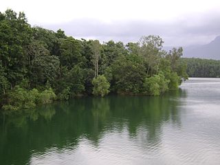
Most of Kerala's native habitat, which consists of wet evergreen rainforests at lower elevations and highland deciduous and semi-evergreen forests in the east, has a humid tropical climate. However, significant variations in terrain and elevation lead to high biodiversity. But Alappuzha district has no forests.
The Agasthyamala Biosphere Reserve is a biosphere reserve in India established in 2001, located in the southernmost end of the Western Ghats and includes 3,500.36 km2 (1,351.50 sq mi) of which 1828 km2 is in Kerala and 1672.36 km2 is in Tamil Nadu. It encompasses the following wildlife sanctuaries: Shendurney Wildlife Sanctuary, Peppara Wildlife Sanctuary, Neyyar Wildlife Sanctuary, and Kalakkad Mundanthurai Tiger Reserve.
Karimpuzha National Park is a 230 km² proposed National Park located at 11°16′30″N76°25′25″E in the Nilgiri Hills area of Kerala and Tamil Nadu, in South India, IUCN category: PRO

Mukurthi Peak is one of the highest peaks in the Western Ghats, situated on the border of Udagamandalam taluk, Nilgiris, Tamil Nadu, Nilambur taluk, Malappuram, and Kerala in India. It reaches an altitude of 2,554 m (8,379ft), and is the fifth-highest peak in South India.
The Peppara Wildlife Sanctuary is a wildlife sanctuary in Thiruvananthapuram district of Kerala, India. It consists of the catchment area of the Karamana River, which originates from Chemmunjimottai, the tallest hill within the sanctuary. The sanctuary is named after the Peppara Dam, commissioned in 1983 to augment the drinking water supply to Thiruvananthapuram city and suburban areas. Considering the ecological significance of the area, it was declared a sanctuary in 1983. The terrain is undulating with elevation ranging from 100 m to 1717 m. The area of the sanctuary is 75 km2 with tropical moist evergreen forests and myristica swamps. It is part of the Agasthyamala Biosphere Reserve. Peppara Wildlife Sanctuary is 44 kilometres (27 mi) by car from the nearest railway station, at Thiruvananthapuram, and 49 kilometres (30 mi) from the Thiruvananthapuram airport.

Pampadum Shola National Park is the smallest national park in Idukki district of Kerala in India. It is on the border with Kodaikanal, Dindigul district of Tamil Nadu. The park is administered by the Kerala Department of Forests and Wildlife, Munnar Wildlife Division, together with the nearby Mathikettan Shola National Park, Eravikulam National Park, Anamudi Shola National Park, Chinnar Wildlife Sanctuary and the Kurinjimala Sanctuary. The park adjoins the Allinagaram Reserved Forest within the proposed Palani Hills Wildlife Sanctuary and National Park.It is a part of Palani hills stretched up to Vandaravu peak. The Westerns Ghats, Anamalai Sub-Cluster, including these parks, is under consideration by the UNESCO World Heritage Committee for selection as a World Heritage Site.
New Amarambalam reserved forest is a reserved forest in the Western Ghats, situated in the Malappuram District of Kerala state of India. It extends till Silent Valley National Park of the Palakkad District to the south and to Nadugani in the Nilgiri District of Tamil Nadu to the North. It is under the Karimpuzha Wildlife Sanctuary.

Nilambur Elephant Reserve is a wildlife reserve in Kerala, India. It has a total area of 1419 (sq. km2) and was created in 2002 as part of Project Elephant. The reserve is one of four in Kerala; the state having an elephant population of 5706 in 2018.
